
13 January 2021
The 7 August 2020 landslide in Gokseong County, South Korea
Posted by Dave Petley
The 7 August 2020 landslide in Gokseong County, South Korea
In early August 2020 a period of heavy rainfall in South Korea triggered multiple landslides, killing several people. In terms of loss of life the most significant event occurred on 7 August 2020 in the village of Osan in Gokseong County, South Jeolla Province, in which five people were killed. There is an initial report on this landslide in the journal Landslides (Choi et al. 2021), which is really quite interesting.
The image below is taken from the paper, providing a vertical aerial photograph of the aftermath of the landslide:-
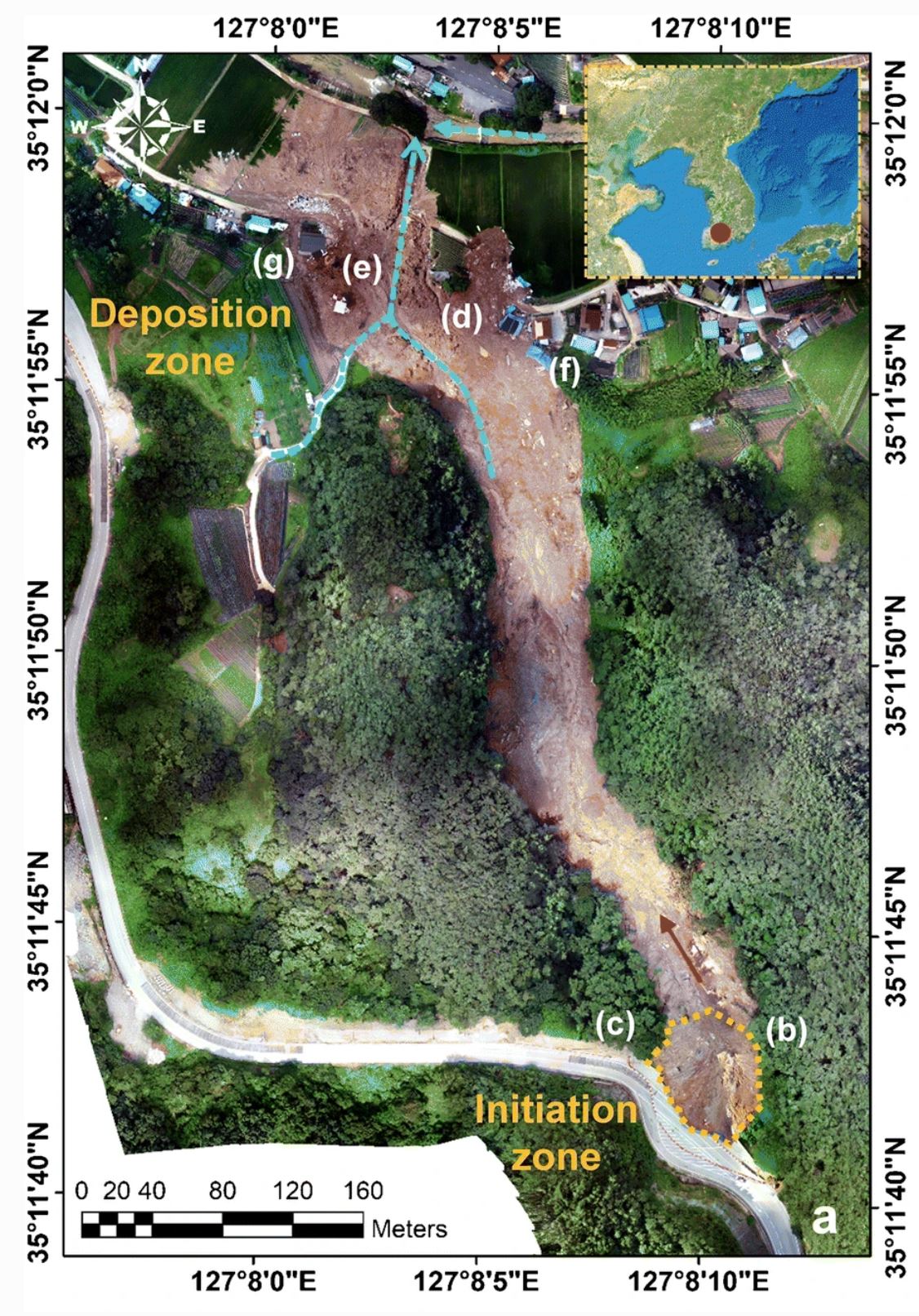
A vertical aerial photograph of the landslide at Osan in Gokseong County, South Korea. Image from Choi et al. (2021).
.
The landslide initiated at the bottom of the image and moved towards the north. It traveled a total distance of about 680 metres, with a volume in the order of 20,000 to 50,000 cubic metres. In the deposition zone it inundated five houses, killing all five of the victims.
As noted above the landslide was triggered by heavy rainfall. Choi et al. (2021) note that the cumulative rainfall in Gokseong County for the 3 days preceding the landslide was of 277 mm, with a peak intensity of over 50 mm per hour.
The most interesting aspect of this work though is the initiation of the landslide. As the image above shows, the crown of the landslide is adjacent to a road, and close examination of the image shows that road widening work was underway at the time of the failure. Choi et al. (2021) have observed that initiation was through the failure of a valley-filling embankment with embedded geogrids supporting the road, National Route 15. The failure surface of this fill slope removed a section of the under construction northbound lane of the highway. After failure it appears that the fill went through static liquefaction and transitioned into a debris flow that struck the houses. The debris flow included the concrete blocks that formed a part of the embankment, increasing its destructive power.
So, although his was a rainfall induced landslide, it is an anthropogenic slope that was responsible for the fatal landslide. Choi et al. (2021) speculate that during the temporary works the embankment might have lacked adequate drainage, allowing the landslide to occur.
.
Reference
Choi, S.K., Ramirez, R.A. & Kwon, T.H. 2021. Preliminary report of a catastrophic landslide that occurred in Gokseong County, South Jeolla Province, South Korea, on August 7, 2020. Landslides. https://doi.org/10.1007/s10346-020-01616-y
 Dave Petley is the Vice-Chancellor of the University of Hull in the United Kingdom. His blog provides commentary and analysis of landslide events occurring worldwide, including the landslides themselves, latest research, and conferences and meetings.
Dave, thank you for sharing, and kudos to Choi and colleagues for getting their research out so quickly.
Below is a HazMapper URL for folks to explore around with. The set up uses a 2-month pre/post window size centered on August 7, 2020. This will allow for quick analysis of additional landslides resulting from heavy precipitation in this part of South Korea in early August. URL is centered on the landslide highlighted in this post, for starting reference.
https://cmscheip.users.earthengine.app/view/hazmapper#lon=127.13449409940885;lat=35.1975062436604;zoom=16;dataset=0;prewindow=2;postwindow=1.5;maxCloudCover=0;slopeThreshold=0.01;eventDate=20200807;
Truly unfortunate for those living below. It’d be interesting to see how the roadway and construction works surface drainage was addressed. Sometimes these slopes are just barely hanging on, and just a little “extra something” sets them off during an extreme event. I and other regulatory colleagues saw many private and public road failures like this after the El Nino winter of 1996-1997. It was often poorly controlled surface runoff that added that “something” to fill slopes like these.
Such “through fills” in stream channels typically have culverts (cross drains), drain pipe under the fill for surface drainage. Pipe diameter is often under-fit, to save cost of pipe. And small pipes in forested areas are readily plugged by organic material and sediment, in which case the road fill serves as a dam. Stream channels also receive excess excavation from steeper slopes. Sizing drain pipes to pass maximum credible flow and avoid debris plugging is often more economical than building a fill that is designed to retain water.
To resist failure, engineered fills are built on a foundation free of organic contamination and unsuitable soil. Fill is placed as horizontal layers, about 0.3 meters thick, each layer compacted to at least 90% of ultimate soil density, 95% where down-slope values are high. Stability of fill can be further improved with fiber reinforcement placed at a high angle to potential failure surfaces.
Soil engineers and engineering geologists have the skills to design fill to appropriately optimize economics and effectiveness.