
13 August 2020
Stonehaven: landslides on the UK railway network
Posted by Dave Petley
Stonehaven: landslides on the UK railway network
Yesterday a train derailed close to Stonehaven in Scotland, killing three people and injuring a further six. Images show that the accident was extremely serious – it is fortunate that there were only 12 people on the train at the time of the accident. A more densely occupied train would have led to a high level of loss of life.
The accident occurred in the aftermath of heavy rainfall, and there were reports of both landslides and floods on the track. As a consequence the accident has been widely reported as being initiated when the train struck a landslide. This may well be the case, although it is speculation at this point. From the drone footage and images of the site, I cannot see an obvious landslide:-
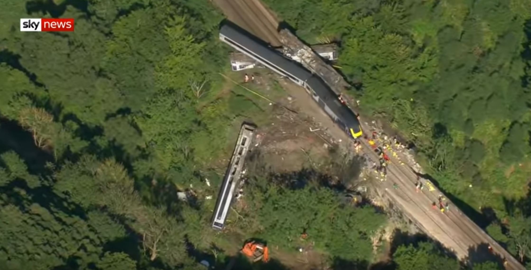
The aftermath of the Stonehaven rail accident. Still from footage posted to Youtube by Sky News.
.
The landslide could of course be obscured by the wreckage or be located off screen. Time will tell, and the accident will be investigated in full.
The Stonehaven accident has raised questions about the safety of the UK rail system, and in particular the risk of landslides. As usual there is a subtext that in some way the operator of the tracks, Network Rail, is failing. I think that is unfair, but that there are reasons to be concerned.
Most of the UK rail system is old – in many cases really old. The section of the alignment near to Stonehaven on which the accident occurred was built between 1847 and 1850. Of course the track, the signalling, the ballast etc have all been replaced, but the earthworks were constructed at that time and in most cases remain extant today. This is ageing infrastructure, constructed when understanding of slope stability was low, primarily through trial and error. Huge sections of railway lines in the UK are either on embankments or below cuttings, so Network Rail has 190,000 anthropogenic slopes to manage.
In the years after construction these slopes were actively managed. Gangs would go out to remove excess vegetation, clear drains, etc., and they acted as an early warning system if slopes were deteriorating However, in the latter years of the nationalised British Rail, and in the disastrous years of the privatised Railtrack, the earthworks were neglected and the slopes deteriorated. In particular, drains were damaged, leading to stability problems.
Network Rail has worked hard to put this right. They have sophisticated methods for identifying and monitoring problematic slopes, and are really good at re-engineering failing earthworks. But the legacy of those years of neglect remains.
Of course there is an additional problem – climate change. The slopes were designed for conditions that differ from the modern situation. In particular, these slopes are now subject to long, very dry spells in which they desiccate and crack, followed by periods of intense rainfall that exceed their drainage capacity. The last few days have seen record-breaking heat followed by very extreme convective rainfall. Some slopes simply cannot cope.
This is not to say that our railways are dangerous – the Stonehaven accident is the first loss of a rail passenger in a derailment in 13 years, an exceptional record. But we do have to recognise that we have both a legacy and a modern slope problem that will present an increasing level of risk, primarily of disruption.
This can be managed – Network Rail and their contractors know how to manage and upgrade the slopes throughout the rail network in the UK; they need to be given the resource to do so.
.
Quickslide 1: A landslide in a caravan park in Fife, Scotland
Heavy rainfall in Scotland also caused a landslide that damaged a set of residential caravans. Fortunately, so-one was injured.
.
Quickslide 2: A valley-blocking landslide on the Sakunka River in Canada
In Canada, a large landslide has created a dam on the Sakunka River south of Chetwynd.
 Dave Petley is the Vice-Chancellor of the University of Hull in the United Kingdom. His blog provides commentary and analysis of landslide events occurring worldwide, including the landslides themselves, latest research, and conferences and meetings.
For your Quickslide 2 link – the name of the river is spelled incorrectly – it’s the Sukunka river, not Sankunka.
There are more pictures of the landslide on the Peace River Regional District Official Facebook page.
https://www.facebook.com/OfficialPRRD/
They have one with a map that shows the general location of the landslide.
I think that whatever caused the train to derail is probably out of the picture.
In your upper photo the yellow-ended rear locomotive stands out clearly – and it appears to be largely intact.
The leading locomotive is in very bad shape (probably a burnt hulk) on the side of the slope – but hidden by the bushes.
I think the carriage that has fallen a long way down the slope would have been the 1st carriage.
The second carriage is the one lying underneath a pile of other carriages.
While I might have the above two carriages round the wrong way, I’m pretty sure that the 3rd carriage is the one lying upside-down off to the right. The largely intact 4th carriage and rear loco are obvious.
The train was moving from the bottom right corner of the photo, upwards towards the top of the photo.
This suggests to me that the source of the derailment is probably just out of the bottom right of the picture.
A bridge is involved and its parapets have been destroyed. This suggests to me that the derailed loco and carriages were already ‘well out of shape’ as they ‘flew’ across the bridge.
https://wpcluster.dctdigital.com/eveningexpress/wp-content/uploads/sites/10/2020/08/PJ-KE-130820-01-007_36077026_36077108.jpg
Lastly, there is a mysterious orange digger. If it was part of the rescue operation, it is quite unclear to me what it was doing. . . . https://e3.365dm.com/20/08/768×432/skynews-train-scotland_5065714.jpg?20200812160238
There appears to be a deepish cutting about 100m south of (what I think is) the crash site – where a landslide could have occurred.
https://www.google.co.uk/maps/@56.9512798,-2.3210434,304m/data=!3m1!1e3
It’s truly alarming to think of how much of our highway and railway grading and drainage — even that which has been maintained – was based on outdated and now invalid climatological data.
I have professional railway geotechical experience of the slopes on the railway in question from some years ago although I am not familiar with this one slope. I suspect that the slopes themselves are not the main problem and, in this case, it could even be a natural slope that was affected by overwhelming amounts of rainwater flowing down along a new, temporary path and eroding away the surface of the hillside-none of the pictures or videos give a clear view as the hill is covered with trees. In my experience this is what I have seen happening in the new era of extreme rainfall events.