29 January 2021
An interesting example of coastal erosion at Happisburgh in Norfolk
Posted by Dave Petley
An interesting example of coastal erosion at Happisburgh in Norfolk
Large parts of the coastal cliffs in the county of Norfolk, in eastern England, are subject to rapid (and accelerating) rates of erosion. The very weak materials offer low resistance to the remorseless attack of the North Sea waves. As storminess increases, and the sea level rises, naturally high rates of erosion are accelerating.
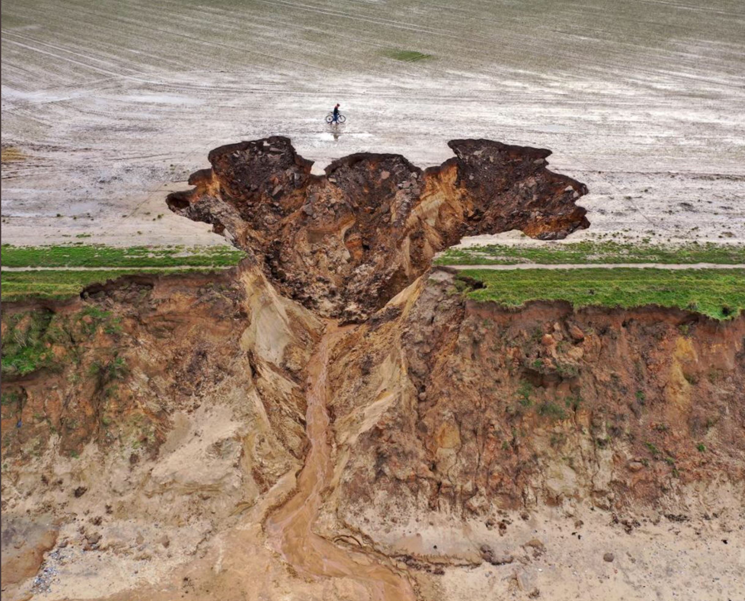
Last week a major storm system, Storm Christoph, passed across the United Kingdom, bringing heavy rainfall and strong winds. Landslides were triggered in a number of locations, including on the railway network (a problem that I have described previously). Close to the town of Happisburgh in Norfolk an interesting erosional feature has developed on the coastal cliffs.
The image below has been tweeted by several people (the source is unclear to me, possibly Getty Images). It is a very clear illustration of the erosion – and note the person on a bicycle for scale:-

The aftermath of the coastal erosion at Happisburgh. Image tweeted, the original source may be Getty Images.
.
The Bacton Coastguard has also posted a nice ground level video of this feature on its Facebook Page.
Technically, this is probably an erosion event rather than a conventional landslide. My interpretation is that the rainfall intensity exceeded the infiltration capacity of the soil in the field, generating overland flow. This has found a small topographic dip in the cliffs, driving the generation of a channel. From this point onwards it has allowed the flow to intensify and downcut, and then to drive retrogressive erosion. There will have been multiple small slope failures contributing to this process both on the cliff line and within the retrogressive bowl as the water drove undercutting.
Of course this will now drive a rapid setback of the cliffs in this area of the Happisburgh coastline in future storm events. Unfortunately the farmer is likely to lose a substantial amount of land.


 Dave Petley is the Vice-Chancellor of the University of Hull in the United Kingdom. His blog provides commentary and analysis of landslide events occurring worldwide, including the landslides themselves, latest research, and conferences and meetings.
Could be triggered by internal erosion, leading to failure backward too.
How effective have the councils interventions contributed towards the coastline. And how do they residents of this area feel about this?
@David The erosion has been going on at least since Roman times, so it’s not as if it’s something that’s new or not known about:
https://withernsea1.co.uk/CCO-LostVillages.html
Nice and spectacular example of a bank gully triggered by concentrated overland runoff flowing over an earth bank. It is a typical case where hydraulic surface and subsurface erosion (piping) and mass movement processes act simultaneously. Jean Poesen
Have you also looked at the soil temperature if it has any role on enhancing the erosion process, especially in the face of global warming, if the soil temperature is also increasing, whether it can have some roles as well
Hi Dave, this feature looks very similar to gullies we investigated along the Canterbury coast, where groundwater erosion plays a key role: https://esurf.copernicus.org/articles/9/1/2021/
Just a note that Happisburgh is pronounced ‘Haze-br-ugh’ The Wikipedia page gives you the phonetic and a recording to make sure you don’t get odd looks if you should venture theer.
I’m the farmer on this land, the winter sea erosion and excessive summer covid footfall removed the vegetative growth on the cliff edge months before, and then large downpours rushed across unestablished cropped fields. The cliff subsidence happened both on the surface and subsurface with a flow of subsurface material flowing well after the weather event.
The cliff seems to be a sand subsoil with a base of clay at sea level which is angled to this low point in the field. and has continued to be eroded in heavy rains, eroding the 12 meter grass margin I have drilled this summer.
I am looking to prevent but probably only slightly subdue the erosion with a combination of banking, larger grass verges and subsurface drainage of the cliff and hope to put forward a proposal for government aid.
I would very much appreciate any suggestions.