
3 September 2010
August fatal landslide data
The end of the month marks the point at which I post the accumulated totals for fatal landslides, based upon the global fatal landslide database that I maintain. The raw figures for August are stark. The total number of fatal landslides recorded in the month was 71, resulting in 2,740 fatalities. This total is of course dominated by the Zhouqu landslide in China, which is reported to have resulted in 1,765 deaths. (Click on read more to access the remainder of this post).
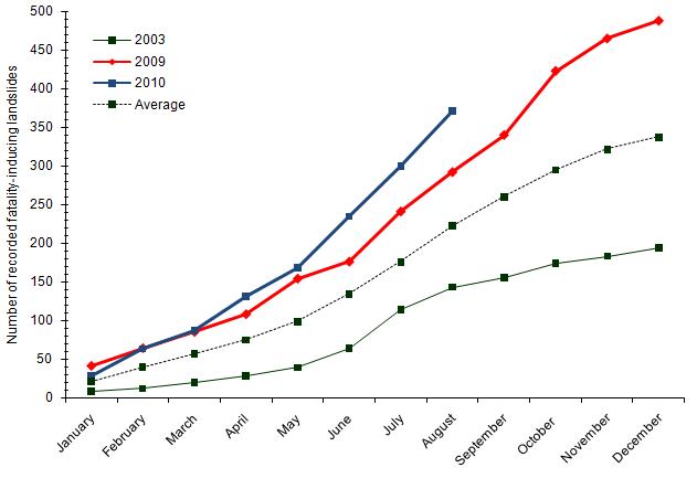
These totals continue the exceptional trend of landslide occurrence in 2010. The average number of recorded fatality-inducing landslides in August in the period 2002-2009 is 46.7, resulting in an average of 348.3 deaths.
This graph illustrates the magnitude of the anomaly for 2010 to date. This shows the cumulative total number of recorded fatality-inducing landslides for 2003 (which had the lowest total of any year on the database), 2009 (the previous record year), 2010 to the end of August, and the average for 2003-2009. There is no doubt that 2010 is exceptional:
It is interesting that these totals have been recorded in a year that to date has had exceptionally low levels of tropical cyclone activity – indeed Northern Hemisphere tropical cyclone energy release remains at the lowest level for 30 years. When they occur, landfalling NW Pacific tropical cyclones (typhoons) have a major impact upon landslide occurrence. It is notable in particular that the Philippines and the Caribbean islands (especially Haiti) have been spared substantial tropical cyclone events to date this year. Given that there are strong signs that tropical cyclone activity is currently increasing in both the N. Atlantic and the Pacific, the next month will be very interesting.
Of course, the root cause of the exceptional occurrence of recorded landslides in August has been the intensity and volume of rainfall associated with the summer monsoon, primarily in China and Pakistan, and to a lesser extent Nepal. The monsoon should start to weaken during September, but more landslides are likely in the interim given the near-saturated state of the ground.
2 September 2010
Another large landslide in China
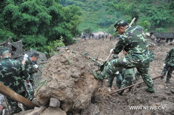
China has today suffered another large landslide event. Xinhua reports that a slide happened at 10:20 pm on Wednesday in the village of Wama in Longyang District, Yunnan, leaving 8 people dead and 40 missing. Xinhua have this image of the slide:
As far as I can tell, this is the location:

Unfortunately the Google Earth image for this area is poor, but there is a report on a small hydro-electric scheme at this village available online here. I should add that I am not suggesting that the HEP scheme was responsible for the slide. This article on recent permission for logging in the area is also interesting.
1 September 2010
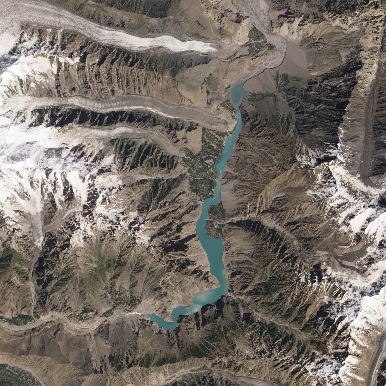
The latest NASA image of Attabad
NASA have released another spectacular satellite image of the Attabad dam and lake. In the article they focus on the upstream end of the lake:

The article states that the water level can be seen to have dropped as the area upstream of Hussaini is no longer inundated. Now there is some evidence that the water level has dropped a little – the Pamir Times reports 12 feet (4 metres), although this may well be a downslope distance rather than a vertical fall. As inflow decreases the water level should decline until the outflow balances this amount. The Pamir Times article above also alludes to operations on the spillway, though it is unclear as to whether these have actually started. I think that it is more likely that the apparent drop in the imagery is actually due to sedimentation in the river channel. This is supported by a close look at Hassaini itself, which shows no signs of a drop in water level.
To me the most interesting aspect of this new image lies in the main part of the lake:
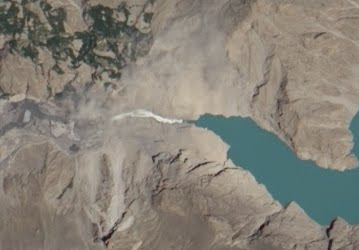
This is a comparison of the two most recent images of the landslide scar, dam and spillway area. The first was collected on 7th July. Note that it is partially obscured by dust:
Whilst the second is the most recent image, collected on 23rd August:
The key thing to note is that the spillway has evolved considerably – it has widened and become more sinuous. There is also some apparent change in the water flow upstream end of the channel, which appears to be more turbulent now. This could be due to a change in the volume of flow. Finally, note that there also appears to be a couple of dust clouds in the upper part of the scarp area, suggesting that this is still evolving.
All of this means that system has not yet reached an equilibrium state, and thus remains a threat. Fortunately though as winter approaches the risk of a rapid collapse is reducing, although unfortunately not to residual levels.
31 August 2010
Catching up – recent landslide events
The next few posts will be an attempt to catch up on the things that I missed whilst on vacation in Switzerland last week. Thanks to the many people who have tipped me off about landslide events. I will cover Pakistan in another post.
1. A large flow in Austria
Thanks to Martin Springer for highlighting this one. On Saturday 21st August a severe storm triggered a 100,000 cubic metre flow in the Karwendel Nature Reserve. Fortunately no-one was killed, but a dozen cars are trapped in a car park. It will take two months to clear the debris. There is a short video of the deposit and further details about the landslide (in German) here.
Read more by clicking below:
2. The power of a mudflow illustrated by an articulated truck in California
Thanks to Lisa Denke for this one. A large storm in eastern California on Thursday last week triggered a mudflow in the Owens Valley in eastern California. An articulated truck (known as a tractor trailer in the US) was caught in the path. There is a short but useful video of the event in this news report:
http://content.secondspace.com/news/detailsplayer.swf?videoSrc=http://kidkbim.s3.amazonaws.com/floodtru-1282928772.1.mar.mp4&prerollAdTag=http://ad.doubleclick.net/pfadx/KBAK/LOCAL;tile=1;sz=320×240;ord=17211858&clickURL=http%3A//www.bakersfieldnow.com/home/video/101657338.html&startPlaying=false
3.An excavator in Gilgit-Baltistan
Accompanying the video above is an extraordinary image of the aftermath of the rains in Pakistan, courtesy of the Pamir Times:

I am reminded of the old “how does the driver of a snowplough get to work?” line.
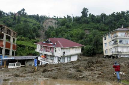
4. Devastating landslides in Turkey
Also on Thursday last week, heavy rainfall triggered landslides in the town of Gundogdu, in Rize Province in Turkey, killing 12 people. The image below is taken from this news report:
5. The typhoon season has now got started
Finally, the very slow start to the Pacific typhoon season has now come to an end, with a series of storms developing at the moment. The three storms currently active all have the potential to cause landslides (image from Tropical Storm Risk):
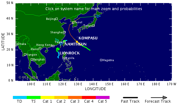
Lionrock and Namthuen could both bring very heavy rainfall to southern China as they track inland over the next couple of days. Meanwhile, the forecast track of Typhoon Kompasu suggests that this very intense typhoon could bring substantial amounts of rainfall to the Korean peninsular. North Korean in particular is very vulnerable to the effects of heavy rainfall due to the extensive deforestation endemic in that country. The potential impacts of this storm are serious, although note that there is considerable uncertainty in track forecasts.
27 August 2010
Amazing new rockfall video from Yosemite
Thanks to Greg Stock for bringing this one to my attention. Yosemite National Park have produced a video providing information for visitors about the hazards associated with rockfalls. It includes an extraordinary piece of footage – captured by a visitor to the park – of a rockfall detaching from the cliff, fragmenting on impact on the the slope, and then travelling down the talus slope. The video of the detachment event is fantastic – I have never seen anything as good. However, the rest of the video is great as well, and will be very valuable to those trying to provide improved awareness rockfalls in many environments. The video should be viewable below (click on read more to see the rest of the post):
Or you can view it here: http://www.youtube.com/watch?v=H0YhlqP1BgE
25 August 2010
Hunza debris flow video
You probably guessed that I am on holiday this week (normal service will be resumed at the weekend), but I thought I’d quickly post this new debris flow video from Hunza in Pakistan. The interesting but starts at about 1 minute 15 seconds:
17 August 2010
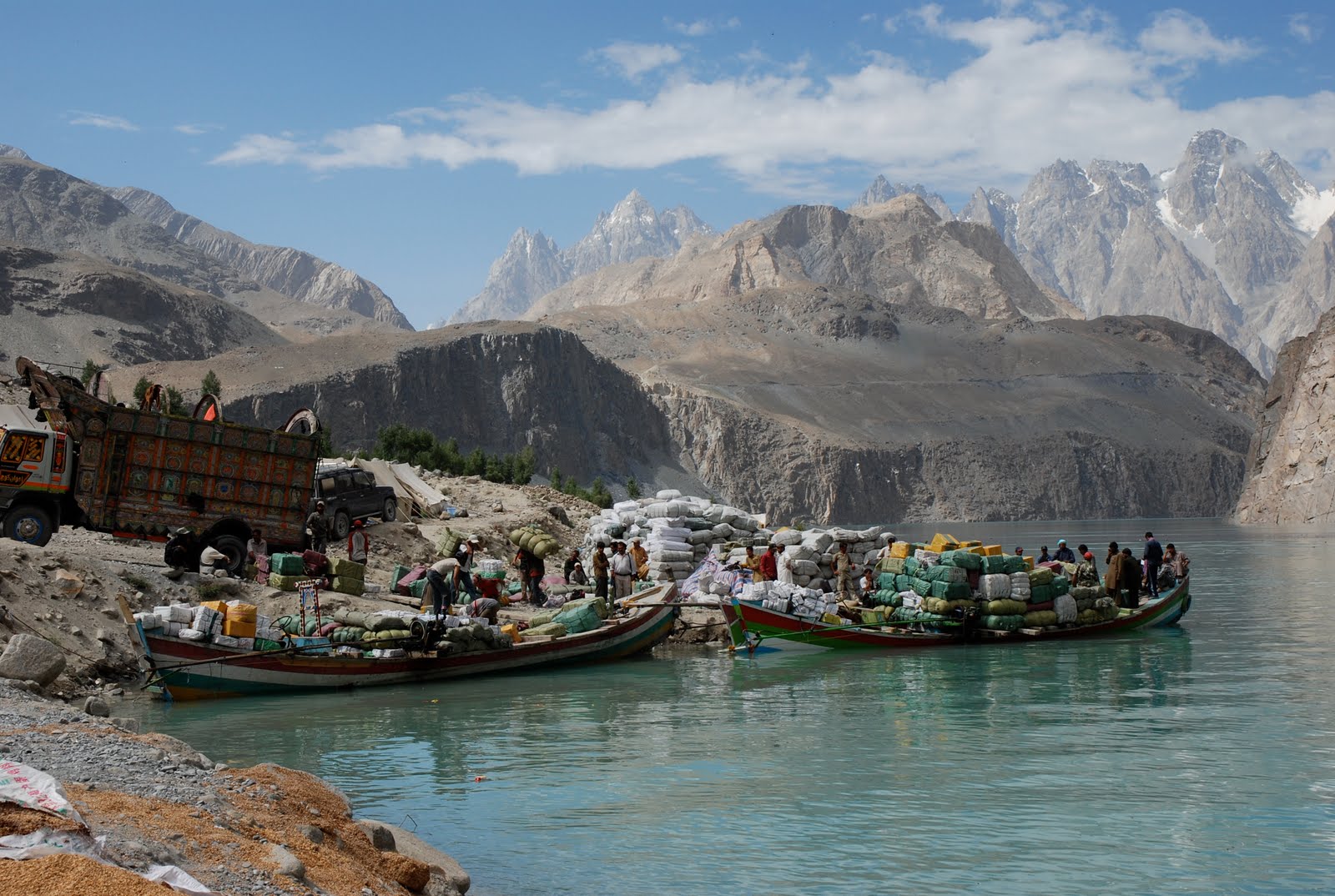
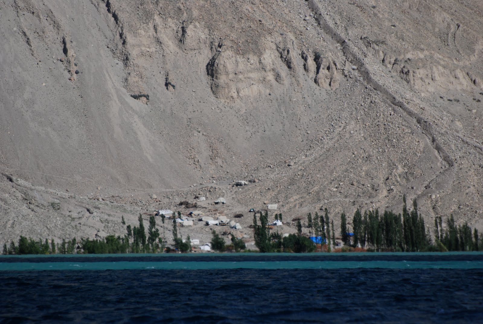
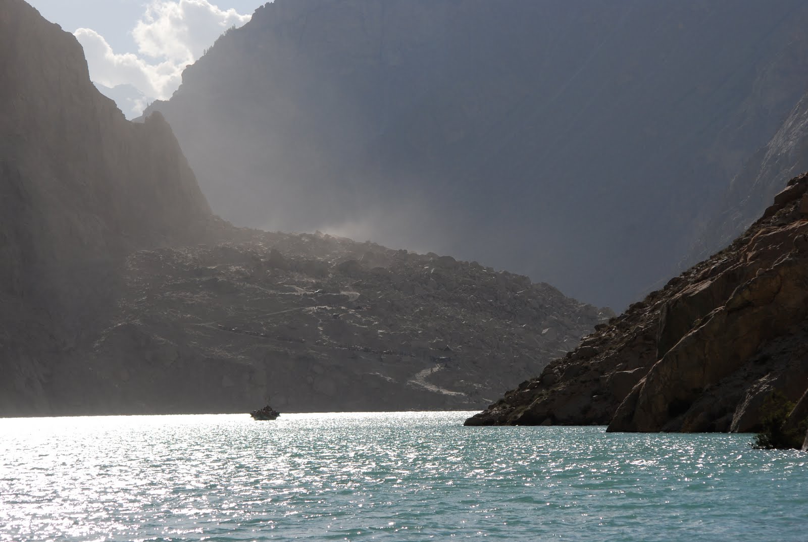
New pictures of Attabad
Many thanks to David Butz, who is a Professor of Human Geography at Brock University in Canada, for sending to me a set of photographs of the situation at Attabad. David was there about eleven days ago, when the boat service was still running (it has now ceased due to a lack of fuel). David has kindly allowed me to post some pictures here – note however that he retains ownership and copyright of them.
The dam from from downstream (click on “read more” to get the remainder of the post):
A close up of the downstream part of the spillway. Note the very large boulder:

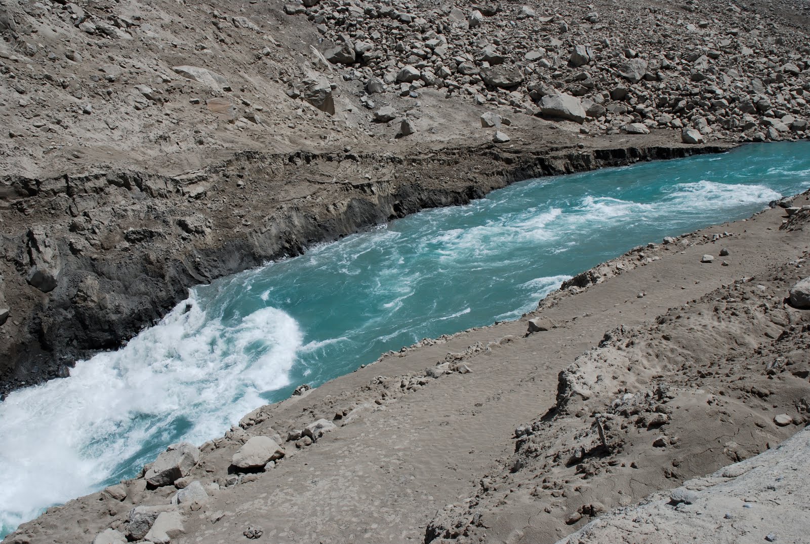
The upper part of the spillway, the point at which the flow rate increases:
The landslide mass from the upstream side:
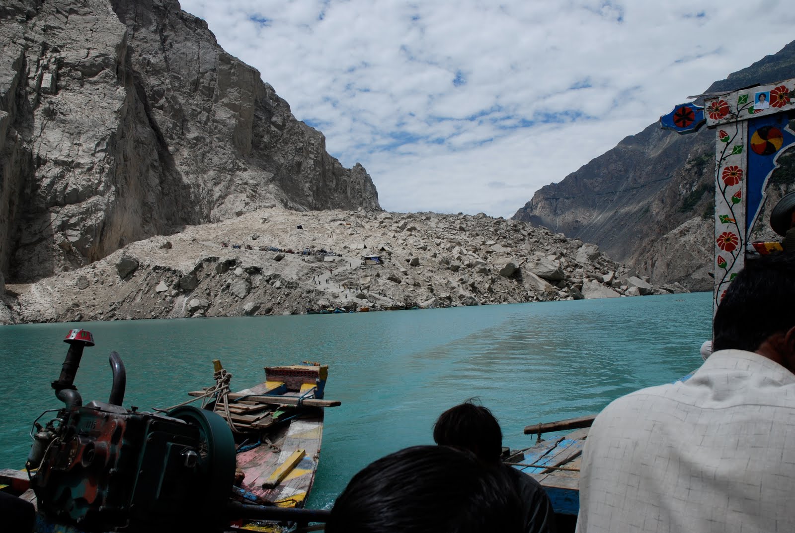
The towering landscape and the heavily overloaded boats that ply the lake:
Many of the displaced people are still located in very hazardous locations:
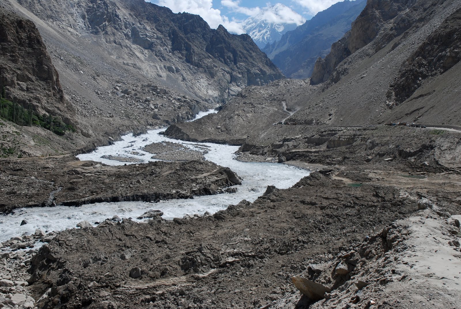
And to finish, the best image that I have seen to date that is able to show the size of the landslide. Remember that the lake is 120 metres deep:
Pakistan flood update: the Kirthar Canal
The floods in Pakistan continue to extend to new areas, increasing the magnitude of the impact on a daily basis. The PakMet hydrographs continue to show increasing flow levels. At Guddu the discharge is still rising, and is now close to the peak level reached in the first flood wave (click on “read more” to reveal the rest of this post):

Meanwhile, as expected serious problems are developing in the area of (but so far not on) the Guddu Barrage, where the discharge is also increasing:
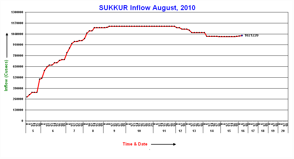
It appears that the second flood wave has not really reached Sukkur as yet. However, Dawn this morning reports that: “…residents of Qubo Saeed Khan town and over 100 villages in Qambar-Shahdadkot district were asked to leave their homes on Monday after a powerful current of floodwaters gushing from Garhi Khairo and overtopping the Khirthar canal smashed five gates of the Garang regulator and washed away the entire structure.”
The importance of Sukkur Barrage and the canal network that extends from it is described in this old Pakistan Observer article “Federal Minister for Labour and Manpowewr Syed Khursheed Ahmed Shah has said that Sukkur Barrage is the lifeline for Sindh’s agricultural economy”. Agriculture in this area is heavily dependent upon the water delivered by this canal network; damage to these structures will represent a major problem in the future. Note also that it is likely that the water will have carried subtantial volumes of silt, which may be deposited in the canal network. This may need to be removed once the floods subside. Meanwhile, the water will have destroyed a substantial part of the cotton crop, which should be harvested next month, which in turn will damage the textile industry. Farmers would normally plant winter wheat in the autumn; the viability of this crop must also be in doubt.
Upstream, the impact of the floods and landslides in the mountains is being well-described by the Pamir Times. The Pakistan High Commissioner in London has stated that rehabilitation will require about $15 billion of investment and a “Marshall Plan” style of approach. It is interesting to see the UK Deputy Prime Minister describing the international response to the floods as “lamentable”. To date the UK has committed £31 million to the Pakistan flood disaster, which to be fair is reportedly a quarter of all of the assistance pledged. However, in comparison with the cost of the Afghanistan and Iraq wars (£20 billion over the last ten years for the UK alone), this amount is tiny. Investing in aid to Pakistan, and being seen to be a force for good in a troubled area, would seem to be a good strategy. Building on the Marshall Plan analogy, isn’t it time for a Berlin Airlift style aid effort?
16 August 2010
Where on Google Earth 211 (updated with result)
There is a long running competition in the Geoblogosphere called “Where on Google Earth” (WOGE), which essentially challenges readers to identify locations pictured on Google Earth imagery. The last was WOGE (number 210), hosted by Meta-Geologist; I was the lucky winner. The winner gains the right to choose and host the next one, so here it is:

The rules of Where on Google Earth are that to win you must post in a comment the location of the image (lat, long), together with a brief description of the reason for its geological interest. The prize is the right to produce and host the next one. You will be unsurprised to hear that the site in question contains a landslide – in this case very a large one.
RESULT: Both Christoph and Jorge were correct in the location. There is indeed an ancient, cubic kilometre scale rock avalancke deposit in the valley, and upstream there are extensive lake deposits. On the basis of this, I declare Jorge the winner, who now gets the right to set the next one.
Dave
The rapidly developing flood crisis in Pakistan: 16th August 2010
The flood crisis in Pakistan continues to develop with a surprising pace. In an earlier post I suggested that this event might be Pakistan’s equivalent of Hurricane Katrina (i.e. a wake-up call for effective disaster management), but now it is starting to look more like the equivalent of the Haiti Earthquake – i.e. an event that is so catastrophic that the coping capacity of the state is exceeded. There is clearly now a need for a huge international response effort.
The PakMet FFD hydrograph data continue to plot the progress or otherwise of the flood waves downstream. Most of the the first flood wave continues to be trapped between Guddu and Kotri. The Kotri hydrograph continues to show alarmingly low discharge values (click read more below to see the remainder of this post):
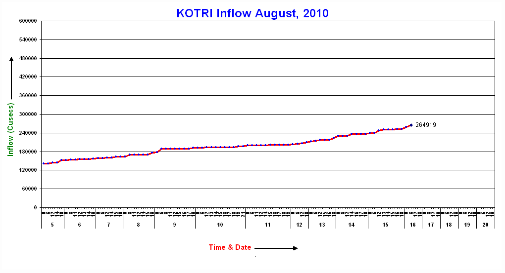
Thus, the majority of the water from the first wave is still in the landscape as the second wave approaches. At Guddu the discharge is rising again:
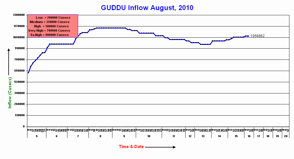
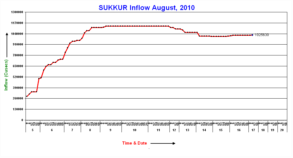
Note that it is still substantially above the “exceptionally high” level. The real concern however must lie in the area around Sukkur, where the water level has hardly fallen from the first event, and is now just starting to rise with the second:
Unfortunately, further heavy rainfall is occurring both in the upstream areas and those downstream as well. The FFD warnings are now expressing quiet concerns about the barrage at Sukkur. The politicians are a little more frank about the situation, according to this report in Dawn:
“The Sindh irrigation minister, Jam Saifullah Dharejo, said the dam in Sukkur faced a major test of its strength as flood waters coursed down the Indus River into Pakistan’s highly populated agricultural heartland. ”The coming four to five days are still crucial,” he said.
Take a look at the Pakistan media reports here, here and here to get an idea of just how bad things are in Sindh now. The prospect of 200,000 people being rendered homeless by a single part of this flood in a single day is quite extraordinary.
Meanwhile, life in the mountain areas to the north is extraordinarily difficult, with areas devastated by the 2005 earthquake being hit by fresh landslides overnight. The Express Tribune has a short article on life in Gilgit, which remains effectively isolated from the outside world. The headline is: “Gilgit travels back in time as flood cripples infrastructure”, which given that electricity, food, water and medical facilities are all in a state of crisis, is no exaggeration.
 Dave Petley is the Vice-Chancellor of the University of Hull in the United Kingdom. His blog provides commentary and analysis of landslide events occurring worldwide, including the landslides themselves, latest research, and conferences and meetings.
Recent Comments