
15 August 2010
Pakistan flood update – 15th August 2010
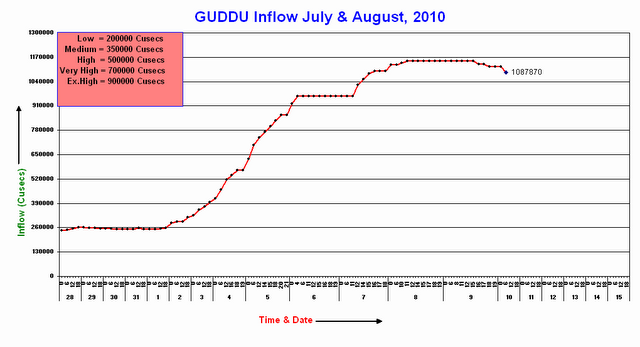
The second flood wave is now starting to affect the most devastated areas of Sindh. The PakMet FFD hydrograph for Guddu has started to show an increase in discharge once again:

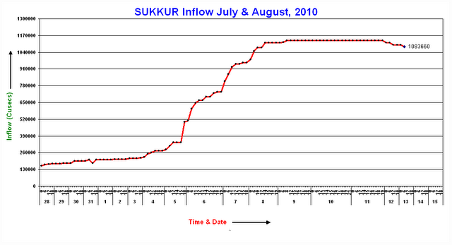
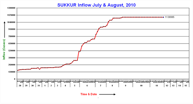
Note that the flood level has been above the exceptionally high (danger) level for ten days now. Downstream at Sukkur the water level continues to fall very slowly, again remaining well above the danger level:

Expect this to start to rise once again in the next few days. Meanwhile, the final downstream station at Kotri the flood level remains very surprisingly low:
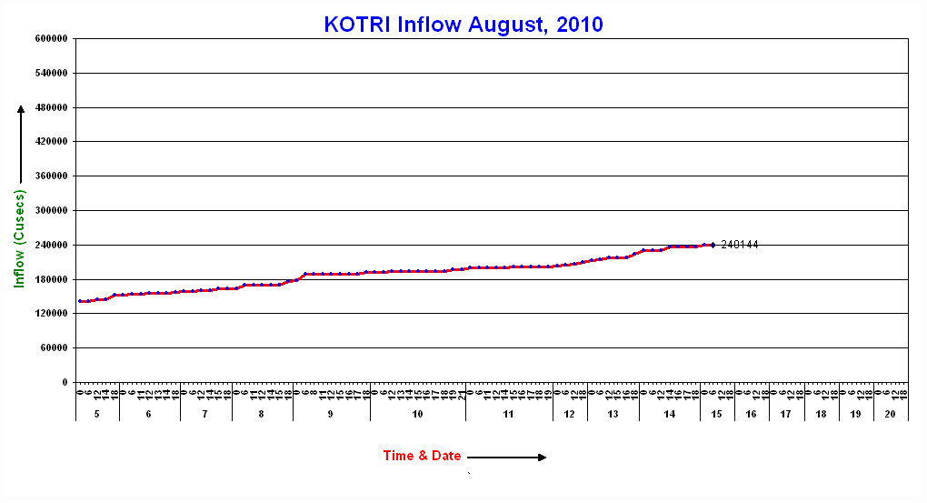
Assuming that these values are correct this must mean that a vast volume of water is being stored in the landscape between Sukkur and Kotri. The flood is certainly spreading across the plains, as this report on new flooding in Jaffarabad demonstrates. This NASA MODIS satellite image shows the area around Sukkur. Notice how the area flooded changes at Sukkur, presumably because of the restriction in the flow by bridges and barrages:

There is a first class UNOSAT flood extent map here. It demonstrates the areas in which the flood is still spreading – a close look is quite horrifying actually – the scale of the disaster is so huge that the media are understandably struggling to provide an adequate picture of the extent.
To multiply the problems the new flood wave travelling down the river. This must be a very worrying situation once the second flood reaches Sukkur. Although smaller than the first wave, the cumulative effects and the existing damage to levees spells a potentially very difficult situation.
Meanwhile, the focus of the media coverage is now on the downstream areas. With 20 million people now directly affected by the floods, this is unsurprising. However, the situation upstream also remains critical. The Pamir Times has a good report on the situation in Gilgit-Baltistan, which is effectively cut off downstream by the loss of the Karokoram Highway and upstream by the Attabad landslide dam:
“The devastating landslides and flash floods that resulted in death of over 120 people in different parts of Gilgit – Baltistan have also blocked supply routes increasing misery and sufferings of hundreds of thousands more.
14 August 2010
An extraordinary year for landslides in China
This morning has brought further reports of heavy rain and consequent landslides in China, with more downpours forecast for the next few days. Meanwhile the recovery operations for the Shouqu landslide continue, marked by a national day of mourning for the victims. Note that the cost of the landslide at Shouqu is now reported to be 1239 people, with 505 still missing.
The landslides in China this year are interesting for both their frequency and their intensity. On average China has the largest number of fatal landslides of any country in the world, but this year has been particularly serious. Based upon the database of fatal landslides that I have been maintaining for the last 8 years, the graph below shows the cumulative recorded number of non-seismic landslides that resulted in fatalities for the last five years in China. The x-axis is the day number in the year (i.e. 1st January = 1; 31st December = 365).

Even before the Shouqu landslide disaster the number of fatality inducing landslides this year was running far above the normal level for the previous four years, and already the total has exceeded the annual totals of all the previous years. This is despite a low impact of landfalling typhoons so far this year (this is unlikely to remain the case to year end).
The Beijing Climate Center produces daily maps of global precipitation anomaly for the last thirty days. This is the latest version covering the last 30 days:

The most obvious aspects of these maps is actually the extraordinary drought in western Russia, but note also
that the high level of rainfall in northern Pakistan and in Central Europe appears. Much of China shows rainfall well above the norm.
13 August 2010
Update on China and Pakistan – 13th August 2010
1. The Gansu landslide in China
The rescue operations in Gansu have now clearly transitioned into a recovery and rehabilitation phase, greatly hampered by continuing very heavy rainfall in the area. Landslides are continuing to occur in the area, with resultant casualties.
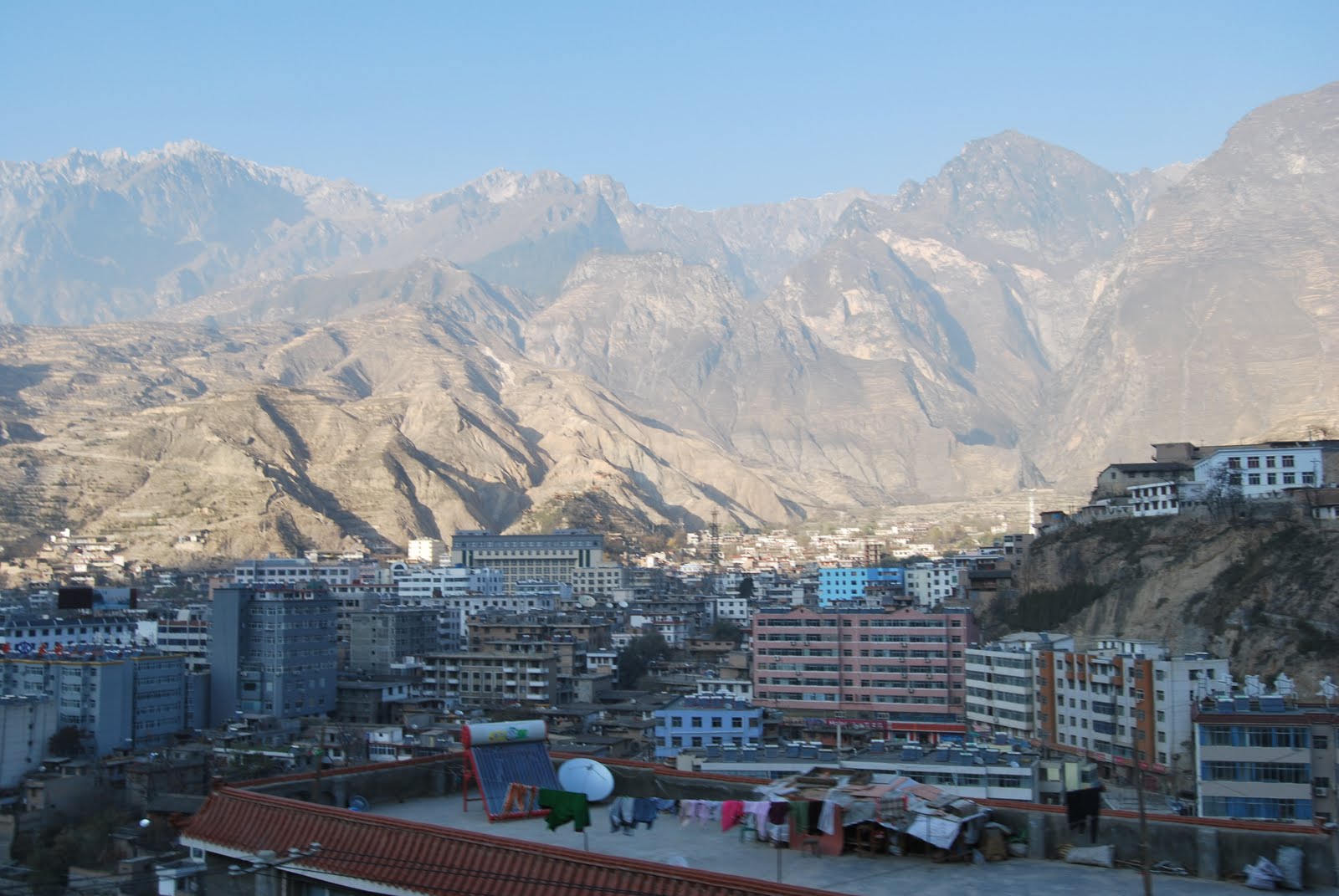
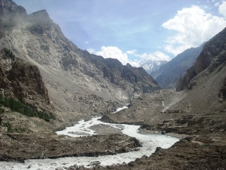
Tom Dijkstra of Loughborough University visited the site as part of a trip to look at collaborative landslide research in the area back in November. He has kindly sent two images of the town to me and has agreed that I can put them online. This image shows the area affected by the landslide from the other side of the river. The steep, deforested mountains in the background are clearly the source of the flow:
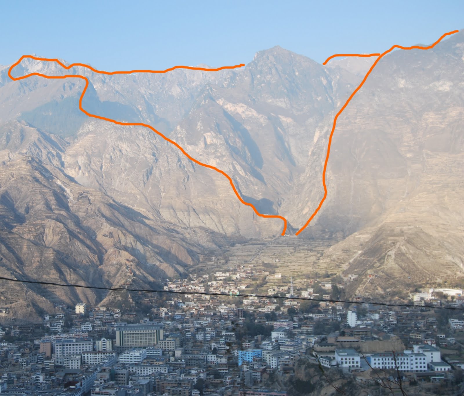
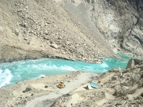
The second image shows the catchment source of the flow:
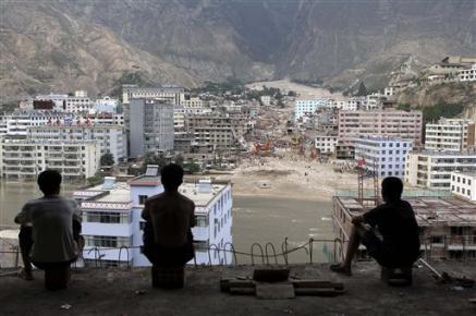
It is worth comparing the above image with this AP picture that I posted a few days ago of the site after the flow:
The reasons for the very high loss of life, now estimated to be 1,144 people, with a further 600 still missing, are clear given the density of buildings in the affected area.
2. Pakistan
The two flood waves in Pakistan continue to cause extreme levels of suffering. According to the FFD hydrographs the water level at Sukkur is now falling slowly after the passage of the first flood wave:
What has been particularly interesting though is that the flood level is not really increasing substantially at Kotri, the large gauging station downstream:

This presumably means one of two things. First, it could be that the water is finding another route – i.e. that it is bypassing the gauging station. Alternatively, the water is in effect trapped between the two sites, which might explain the very slow falling limb of the hydrograph. The Google Earth satellite image below shows Kotri:
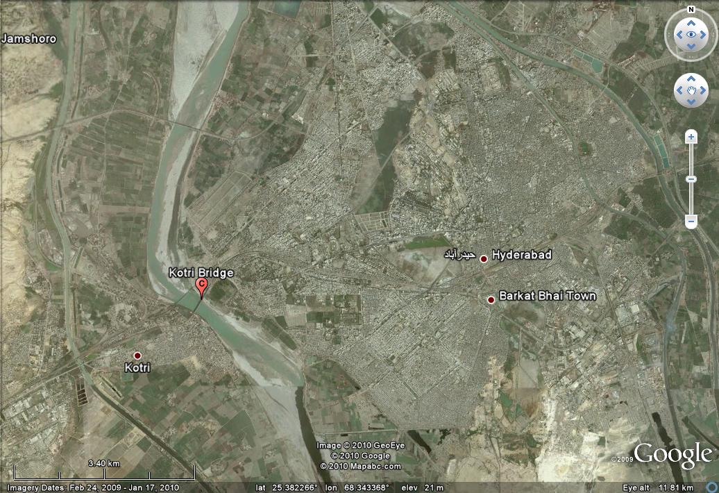
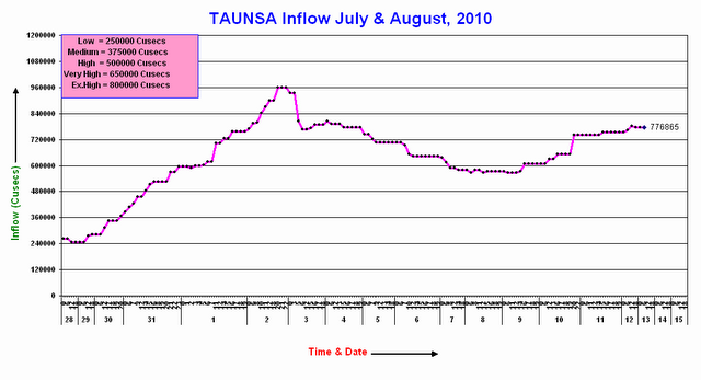
It is possible that the water has flooded the adjacent land, but the news reports indicate that this is not the case, with the suggestion that the bridges downstream of Sukkur are slowing the flow down. This is dangerous in the context of the second flood wave, which at the moment remains smaller than the first. This is the hydrograph for Taunsa, which is just below the “Extremely High” flood level:
At Guddu the discharge is still falling, but only very slowly. Indeed the discharge remains well above the “Exceptionally High” level:

The danger must be that the second flood wave starts to catch up with, and build upon, the stalled first wave. This would create the potential for an extremely damaging second phase of floods. It took six days for the first wave to pass from Taunsa to Guddu, and a further day to Sukkur. The hope must be that the water level starts to fall quickly at these two sites before the second wave arrives.
Unfortunately, it is clear that this slow motion disaster has several more weeks to go, even if there is no further heavy rain.
11 August 2010
Update on the disasters in China and Pakistan: 11th August 2010
Apologies for the tardiness of this update – it has been a busy day! First a heads-up, I will write a post to go on the Institute of Hazard, Risk and Resilience blog on these disasters in the context of climate change in the next couple of days. I will signpost the piece here when it is ready.
1. Pakistan
The sheer magnitude of the disaster in Pakistan is difficult to comprehend. Unfortunately the true horror of this event is probably remaining hidden; the real impact will come when the water levels in the south subside to leave polluted water wells, destroyed homes and wrecked crops. The legacy of this disaster will be long-lasting, and will have a profound impact on Pakistan and elsewhere.
Starting in the north, heavy rain continues to wreak havoc, and the Pamir Times appears to be the only outlet from which a really good idea of the true impact can be gained. In Gilgit-Baltistan the population is isolated by the blockage of the Hunza river to the north, preventing supplies from China, and the loss of bridges and the road to the south, leaving the population in dire need. Electricity, water, food and medicine are in short supply. Meanwhile, the Pamir Times is also reporting a disaster at Diamir, caused by the failure of another landslide dam. They report at least 50 fatalities and 300 houses washed away. Assuming that the report is correct, expect this to make the news tomorrow as word seeps out. One hopes that the toll does not increase further, but I am fearful that this is likely.
To the south, the media has cottoned onto the fact that there is a second wave heading down the Indus now, an issue that I have been highlighting since the weekend. Dawn.com quotes the meteorological service in warning of floods in the northern regions of the Pakistan plains. This second wave is now generating a substantial flood at Chashma:
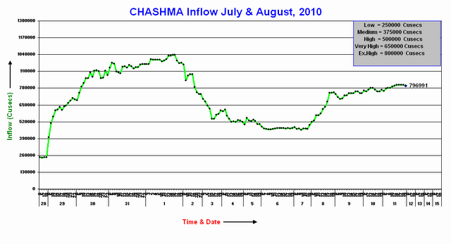
Fortunately it is not as large as the first wave, but is still only just below the “extremely high” category. In the context of already damaged infrastructure, the potential for further destruction is clear.
Downstream at Guddu the hydrograph is falling very slowly, but remains far above the extremely high flood level:

Whilst at Sukkur the hydrograph remains saturated, meaning that the true level is hard to judge:
Unfortunately the first flood still has some way to go before discharging to the sea. The Pakistan Flood Forecasting division must be praised for the brevity of their weather forecasts. Tomorrow’s forecast says:
Several people have asked about a good NGO to whom donations could be made. In this blog I have worked extensively with Focus Humanitarian Assistance, who specialise in providing help to people’s affected by disasters, and who did undeniably wonderful work in Pakistan in the aftermath of the Attabad crisis. As part of the Aga Khan Development Network I believe that they are a safe and honorable NGO, and they remain my preferred partner for work in Pakistan.
2. China
Once again the death toll from the Zhouqu landslide in Gansu has jumped, with Xinhua reporting a total of 1,117 fatalities and a further 627 people still missing. The struggle to breach the partial barrier formed by the landslide across the barrier is intense, with the use of explosives to try to break the blockage. Concern is rising in the light of continued poor weather in the area, with thunderstorms occurring today and heavy rains forecast for the next two days. Meanwhile, there is a fascinating level of honesty in the Chinese media about the likely causes of the landslide. For example, this article explores the contributing factors, whilst in this one a minister reflects upon both climatic extremes and illegal construction. The level of openness is surprising, but very welcome.
The press of course continue to describe the anguish of the families of the victims, especially as the “golden” 72 hour period is now passed. Presumably a decision will be needed soon to terminate the rescue operation and to regrade and entomb the debris. I suspect that it is inevitable that many of the victims will not be recovered, with the site being preserved as a memorial to them.
Finally, Digital Globe have released a very high resolution satellite image of the site of the landslides, which is available here:
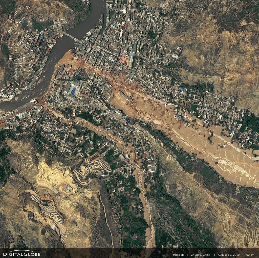
Very useful, but unfortunately, it still does not provide an insight into the source area of the slide – has anyone seen an image of this zone as yet?
More tomorrow.
10 August 2010
Update: Dramatic increase in the loss of life in the Gansu landslide
Xinhua has this morning dramatically increased estimated loss of life in the landslide at Zhouqu in Gansu Province, China. The latest toll is 702 known fatalities and a further 1,042 people missing.
Updates for Pakistan, China and India flood and landslide crises, 10th August
As yesterday, this is a brief review of the state of play with the three substantial landslide and flood crises in Asia.
1. Pakistan
The flood wave continues to work its way down the Indus, and is now in the Province of Sindh. As forecast, heavy rainfall exacerbated the situation yesterday, with totals of over 100 mm in some areas of the province. Kyber-Pakhtunkhwa also saw falls of 30 mm or more in some areas. Whilst not enough to cause the sort of devastation that we have seen of late, this is sufficient to keep river levels topped up.
Working our way down the Indus, the second flood at Besham has now peaked and the hydrograph is showing a rapid decline.
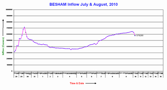
The peak flow in this econd flood was lower than in the first , but was still substantial. This water will of course have to work its way down the Indus over the next ten days. It will be interesting to see how this flood looks when it reaches Taunsa.
Moving down to Guddu, the peak discharge appears finally to have passed, meaning that water levels will be slowly falling. Note however that if the flow behaviour at Taunsa is a guide, the rate at which the water levels fall will be quite slow, meaning that the people have several more days before they will be able to start rebuilding their lives. Note also that the flood level is still above the exceptionally high level. The flat peak component of the flood record causes me to reiterate my suggestion yesterday that the hydrograph shown below has not accurately captured the peak flow:
Going south again, and the main concern is now at Sukkur, where the hydrograph appears to be suffering the same problems of saturation at the peak:

Some media reports have suggested that the peak flow here is actually 1.2 million cubic feet per second. The media are also reporting concerns about the safety of the Sukkur barrage, with several reports suggesting that deliberate breaches of levees are being considered to try to reduce the peak flow. It seems that a similar exercise was undertaken upstream at Ghouspur, with the inevitable destruction that followed. However, it is important to understand that these barrages provide irrigation for vast areas of productive agricultural land that is vital for the sustenance of the population of Pakistan. Deciding on how to protect them is not an easy task.
However, as at Attabad the apparently poor communications strategy of the authorities is unfortunate. Whilst putting the hydrographs online is a good step, it would be sensible to accompany this with a decent explanation of what is happening, where the threats lie, and the action that might be needed to mitigate them. Whilst this would not prevent the destruction, at least people might understand why particular courses of action are being followed.
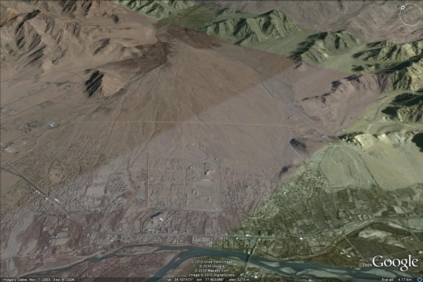
Finally, for northern Pakistan the Pamir Times has provided two updates in the last 24 hours on the Attabad situation. Most importantly, the water level is now falling, having apparently risen by 6 feet (about 1.8 metres) at the peak of the floods, which caused further widespread destruction. Meanwhile, they continue to note that other landslides have caused severe hardship, and that the Hunza was blocked at Rahimabad to the north of Gilgit. As far as I can tell Rahimabad is in the valley shown in the Google Earth image below:

Meanwhile, the Pamir Times has also provided some new images of the state of the Attabad barrier itself:
These appear to indicate little change in the state of the dam over the last couple of weeks. Operations to lower the spillway level have yet to start, but it is heartening to see in some of the images that a monitoring team appears to still be on the site.
2. China
Rescue operations continue at the Zhouqu landslide site, where the number of known fatalities is now 337. The reported number of missing people is 1,148. There can be little chance of recovering many further survivors, although one victim was recovered alive today. The state media are reporting some tales of real anguish in the aftermath of the disaster, exacerbated of course by the “one child” policy in China. The government is attributing the disaster to the normal villains – poor geological conditions, the recent drought, the heavy rainfall, and the aftermath of the 2008 earthquake. This is all likely to be true to at least some degree, but there may be other factors as well, most notably deforestation and the legacy of mining activities. The internet age has spawned a wave of amateur investigative journalism in China. This All Voices page reviews recent postings of Chinese documents about the landslide hazard in Zhouqu. Whilst I am naturally sceptical of some of this material, it does appear that the risks to communities posed by landslides in these mountains is well-documented. In particular, this newspaper article, from 2008, identifies that the slope problems at Zhouqu are sufficiently serious that they have been the location of various studies by Japanese landslide scientists. However, to be fair to the government, the range of landslide problems in the aftermath of the 2008 earthquake is so serious that prioritising and finding resource to mitigate appropriately is impossible. Expect more landslide disasters in central China in the coming years.
Two images have appeared in the last 24 hours that demonstrate the magnitude of this slide. This AP image shows the landslide from the opposite bank:

I would really like to see the source of this huge debris flow – has anyone seen an aerial image of the upper reaches of the track as yet?
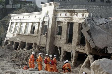
And this AP image illustrates the likely velocity of the movement, given away by the mud deposit on, and indeed in, the upper part of the building:
Finally, unfortunately tropical storm Dianmu is moving northwards off the east coast of China. Although it is unlikely to landfall in China itself, expect heavy rainfall across eastern and central China. Given the intensity and magnitude of the recent rainfall, this is potentially deeply problematic.
3. The Ladakh debris flows in India
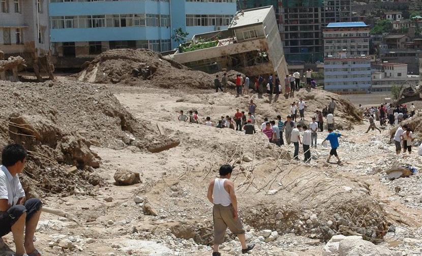
The forgotten disaster amongst everything else that is going on is the Ladakh debris flows that occurred on Friday. To date the number of known victims is reported to be 165 people, with a further 500 thought to be missing (with very little chance of survival now). However, Save the Children is reported to believe that the true toll is likely to be in excess of 1,000 because several affected villages have yet to be accessed. Localised heavy rainfall continues in the area, disrupting relief operations and causing further damage.
One of the most seriously affected towns was Choglamsar. This is the settlement in the foreground of the perspective Google Earth image below – the presence of the huge debris fan in the background is a clear sign of the processes that have allows the formation of the comparatively flat areas upon which the town is built:
Protecting the town against repeats of this event is not going to be an easy task, but debris flows must be expected on a fan such as this.
I will try to provide further updates tomorrow morning, or sooner if events require.
9 August 2010
Updates on landslides and floods in Pakistan, China and India
It is rather difficult to keep up with all the landslides occurring in Asia at present, so for now I’ll provide a brief review of the current situation across the three major areas affected:
1. Pakistan
The situation in Pakistan becomes increasingly desperate. Further heavy rainfall in the mountains in the northwest has meant increased landslide and flood occurrence, and a huge reduction in the aid effort. The FFD hydrographs in the mountain areas are steadily rising again. For example, this hydrograph is for Skardu shows that flow is greater now than it was in the heavy rainfall of ten days ago:
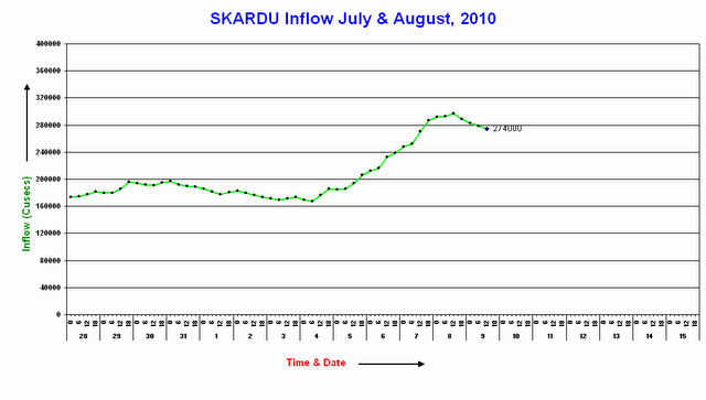
Downstream at Besham (close to the mountain front) the discharge is not as high as it was in the first set of floods, but it is rising and the level is undoubtedly high:

The area under the curve is the total volume of water that has been involved in the flood. This suggests that in terms of overall volume this flood is larger than that of the events last week, even though the peak flow is (so far) lower.
Downstream at Sukkur and Guddu the flow remains exceptionally high. At Guddu the hydrograph suggests that the peak flow has now been maintained for over 24 hours. This looks odd – I wonder whether the discharge has exceeded the capacity of the measurement system.

However, according to the FFD a larger discharge has been measured at Guddu before – in 1986 a discharge of 1,200,000 cusecs (cubic feet per second) was measured at this point.
At Sukkur the discharge is continuing to rise, and based upon the Guddu hydrograph may have some time to go before the peak is reached. The maximum recorded flood at this point is 1,170,000 cusecs in 1986.
GEO News is reporting that the city of Muzaffargarh is now being evacuated. Given that this is a city of 165,000 people, the severity of the situation is clear.
2. China
Xinhua continues to provide full coverage of the desperate attempts to save people trapped by the landslide in Zhouqu, Gansu Province yesterday. The magnitude of the slide is clear from the story of the survivor rescued this morning – she was recovered from a an apartment that had been inundated by debris. The rescuers had to break through a wall to reach her – even though her apartment was on the fourth floor of the building. Meanwhile the landslide dam has been successfully breached, which at least deals with one key issue.
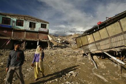
3. India
The debris flow at Ladakh is now known to have killed 132 people, but a further 500 people are reported to be missing. The level of damage is really very high indeed, as this AP image shows:
A fascinating insight into the process that occurred at Leh is provided by this commentary from geologist Ritesh Arya, who was in the head scar area when the failures developed:
Describing the sheer size of the mudslide, Arya said: “Its dimensions make it so scary: it was about 20meter high and several kilometers wide.” All the houses coming in its way appeared to just dissolve into it as it roared on, destroying the Leh bus stand and the BSNL exchange, said Arya. The mudslide is believed to have travelled 6km, bulldozing the Choglamsar village. Arya said most roads have disappeared under the debris. The worst-hit are the heritage buildings and old houses, traditionally made of mud.
“‘People were completely caught unawares. Then suddenly, everyone started scrambling as the enormous amount of loose mud and debris was unleashed. Those who survived in the Choglamsar village had to waded through five-ft high mudflow,” said Arya. “There are bodies still buried in the debris and I found arms and legs sticking out at several places,” he said.”
8 August 2010
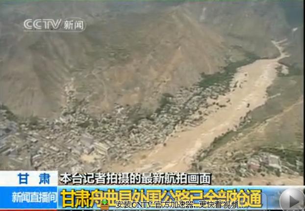
First video of the Gansu landslides
The Chinese State TV company has a new report (in Mandarin) that provides aerial footage of the Gansu landslide site. It is clear from the video that there are in fact two slides. The video is available via the link below (I have removed the embedded video as it played automatically):
The larger of the two slides is shown in this screen capture from the video:
Strangely though neither of these two slides appear to be blocking the valley, as this screen captured image shows:
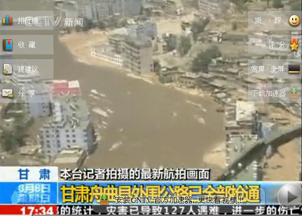
Does this mean that there is another landslide downstream that is blocking the valley?
Update: the Gansu landslide
Xinhua now reports that the death toll from the Gansu landslide is 127 people, with a further 1,294 people reported to be missing. So far just 28 people have been rescued alive.
The BBC has published an image of the lower part of the slide:
Note the water flooding the lower storey of the buildings in the background.
 Dave Petley is the Vice-Chancellor of the University of Hull in the United Kingdom. His blog provides commentary and analysis of landslide events occurring worldwide, including the landslides themselves, latest research, and conferences and meetings.
Recent Comments