
6 December 2011
AGU 2 – Simon Winchester
 At lunchtime today I went along to the Presidential Forum on the topic of Science and Society, which featured a talk by the author Simon Winchester. On the face of it Simon was a great choice as he has written a number of earth science facing popular science books – and indeed I have even read two of them. On the other hand I suspect that his presence raised a few eyebrows as back in March he enraged the geoscience community. The context was the Tohuku Earthquake in Japan – soon after that event he wrote a piece for Newsweek entitled “The scariest earthquake is yet to come” in which he wrote:
Even more worrisome than geography and topography, though, is geological history. For this event cannot be viewed in isolation. There was a horrifically destructive Pacific earthquake in New Zealand on Feb. 22, and an even more violent magnitude-8.8 event in Chile almost exactly a year before. All three phenomena involved more or less the same family of circum-Pacific fault lines and plate boundaries—and though there is still no hard scientific evidence to explain why, there is little doubt now that earthquakes do tend to occur in clusters: a significant event on one side of a major tectonic plate is often—not invariably, but often enough to be noticeable—followed some weeks or months later by another on the plate’s far side. It is as though the earth becomes like a great brass bell, which when struck by an enormous hammer blow on one side sets to vibrating and ringing from all over. Now there have been catastrophic events at three corners of the Pacific Plate—one in the northwest, on Friday; one in the southwest, last month; one in the southeast, last year.
That leaves just one corner unaffected—the northeast. And the fault line in the northeast of the Pacific Plate is the San Andreas Fault, underpinning the city of San Francisco.
All of which makes the geological community very apprehensive. All know that the San Andreas Fault is due to rupture one day—it last did so in 1906, and strains have built beneath it to a barely tolerable level. To rupture again, with unimaginable consequences for the millions who live above it, some triggering event has to occur. Now three events have occurred that might all be regarded as triggering events. There are in consequence a lot of thoughtful people in the American West who are very nervous indeed—wondering, as they often must do, whether the consent that permits them to inhabit so pleasant a place might be about to be withdrawn, sooner than they have supposed.
It is not hard to see why this caused so much upset in the earth science community. Whilst it is undoubtedly true that the San Andreas fault is dangerous, the suggestion that the Tohuku earthquake in some way meant that this fault was more likely to rupture is not supported by the facts.
It is of course important to remember that Simon Winchester is not a scientist – indeed he is a career journalist – and that everyone makes mistakes. As earth scientists we are now in the cross hairs of a whole series of really key science and society issues – climate change, earth resources, fracking, natural hazards to name just four – and finding effective ways to communicate our understanding to policy makers and the public is of course vital. So, in that context, Simon was a great choice of a speaker, and I was expecting a really sparky discussion about an issue that is close to my heart (after all, what is a blog for at the end of the day?).
So, it was something of a surprise to me that he chose to spend his talk discussing his recent book on the Atlantic. Don’t misunderstand me – he was entertaining, eloquent, witty, engaging and persuasive. He talked with passion and zeal. I ended up really wanting to read his book about the Atlantic.
But…this was a forum on science and society! I came away intensely frustrated that he had not talked about an issue that is so important to us. When he finished his talk, he gave a five-minute explanation of what led him to write that Newsweek piece, and I for one understood, related to and sympathised with what he had to say. But it is such a shame that he didn’t use that experience, and his long career as a journalist and a writer, to talk about how to communicate well on challenging topics. I came away thinking that I had heard a great talk, but that it was nonetheless a missed opportunity.
5 December 2011
AGU 1: Landslide characterisation and forecasting

My intention in terms of blogging at AGU is to post on those talks and sessions that I find interesting. This is not going to be comprehensive, and if I miss your talk it does not mean that I didn’t enjoy it or value it. It is just that there is so much…
So first up this morning was an oral session in landslide characterisation and forecasting, which was wide-ranging and very engaging. My thoughts went to Susan Cannon of the USGS, who had the misfortune to talk first (8 am on Monday morning), covering debris flow initiation in the aftermath of wildfires in Southern California. They have classified the landslides according to the intensity of the events (volume and number of debris flows), and then compared this with the intensity / duration relationship for the triggering rainfall event. They achieved impressive relationship between the two, providing an opportunity to develop a warning system that is potentially useful for decision-makers. In many ways the most interesting aspect of this is the ways in which it can be actually used by the emergency services, but unfortunately there was less detail than would be ideal. Sometimes the very short time-slots at AGU (15 mins) are a real constraint.
Next up was a talk by Silvia Peruccacci and her colleagues from CNR-IRPI in Italy, who talked about the development of rainfall intensity – duration thresholds for landslide initiation. This is a well-trodden path, but pleasingly there was a really new element to this work. This was the application of a statistical approach to determine the threshold, a significant step forward. This then allowed objective comparison of thresholds between different areas, between different lithologies in the same area, and between different seasons. I think there are two immediate upshots from this. First, it was interesting to note that in their field area in Italy the winter and the summer thresholds were different – quite a surprising result, and one that I am not sure that I understand. Is this the effect of vegetation I wonder? Second, the overall thresholds proved to be somewhat lower than other studies in the same area had shown. This is great work.
Third into bat was Doug Stead and his colleagues from Canada, who talked about mechanisms of rock slope failure as shown by numerical modelling. Most pleasing about this talk was an emphasis on the importance of the (under-estimated) process of progressive failure, and a recognition of the role of time dependent processes. They are working to analyse that amazing Cornwall cliff collapse video (which gives me an opportunity to show it again):
Doug reported that they have slowed the video down to generate a 15 minute movie that documents the failure in detail. That is something I’d like to see. It is really good to see that a YouTube video is now helping scientific understand of the failure process.
And that was a nice prequel to a talk by Greg Stock and colleagues from the National Park Service of Yosemite and the USGS, which focused on hazard assessment for rockfalls from the cliffs in the canyon. The National Park is quite small but at times houses as many as 30,000 visitors on a single day – a single ill-timed failure could have serious consequences. The biggest concern comes from large boulders that fall from high cliffs and then bounce down the talus slopes, which allows them to run out some quite large distances. Greg outlined the hazard assessment process they have adopted, the results of which are being used to identify buildings at high levels of risk. Those buildings are being closed.
And speaking of acute rockfall hazard, Mauri McSaveney came into bat on behalf of himself and Chris Massey from GNS Science in New Zealand. They reported on their hazard assessment work for rockfall events in the Port Hills area of Christchurch in New Zealand. This is work right at the frontline as the decisions are determining whether individual houses are safe to inhabit. The interesting conclusion from this fascinating work was that many of the houses were at an unacceptable level of risk even before the earthquake. The potential for further seismicity (in the form of aftershocks) has raised this hazard level. This is work of the very highest quality.
A really eye-opening talk was then presented by Valentin Gischig and his colleagues from ETH Zurich, who talked about the role of temperature in the initiation of rock slope failures. Remarkably, they were able to provide compelling evidence that there was a temperature driven effect, resulting in landslide displacements at as deep as 68 m below the surface at the Randa landslide site in Switzerland. They suggest that this temperature-driven effect may be important in controlling the way that the slope is accumulating strain, and thus progressively weakening. I think we had always assumed that temperature effects occur at shallow depths; it is surprising and intriguing to discover that this is not the case.
The penultimate speaker was Ping Lu and colleagues from Tongji University in China and the University of Florence. Over the years I have seen many (maybe even too many) presentations on the use of InSAR for landslide monitoring, but this one had quite a twist. In this case the study used InSAR data to drive a hazard model by combining displacement data with a susceptibility analysis. I suspect that this points to what will become a very important research field in the future as InSAR data becomes better and easier to process. For now it allowed a very interesting estimate of the magnitude of losses from landslides in the Arno River basin in Italy, which came out at 3.22 billion Euros over a 30 year timescale. Ouch!
Finally, Andreas Gunther from BGR Germany, and various colleagues from across Europe, described the process that they are using to develop a pan-Euriopean first order landslide susceptibility map. This is really interesting work that feeds straight into the move towards a European Directive on soils. Perhaps the most impressive element is that they are compiling the European catalogues on landslides – they have over 100,000 landslides in the combined inventory to date – and comparing this with their analysis. The results are quite encouraging, even though the quality of the data is so patchy. Their dataset for landslides in Switzerland for example numbers just 280 – an astonishing under-estimate.
So, all in all this was a great session with eight terrific talks. The poster session walk through is in 20 minutes, so that is where I am heading next.
3 December 2011
Interesting landslide simulation video
Youtube has the following landslide simulation, which is quite interesting:
http://www.youtube.com/watch?v=VV9OVapVC9s
I suspect that the flow rate might be rather high for a slope of that gradient, and the dynamics at the front of the slide look a little odd (I wonder of the modellers have based this on a pyroclastic flow type process?). I do like the way that the failure initiates at the slope toe and then retrogresses, and the way that the flow rates in the centre of the slide are higher than on the margins at the end of the event
2 December 2011
Some interesting natural hazard sessions as the EGU 2012 meeting in Vienna
This evening I start my journey to San Francisco for the AGU Fall Meeting. My plan is to blog and to tweet from the meeting (if I can manage to find five minutes to sit still at any point…). I will be attending many of the Natural Hazards sessions, plus the various blogging events and the social media soiree, and some talks on climate change, geomorphology and suchlike.
Meanwhile, I thought I’d highlight a few sessions that are of interest at the EGU 2012 meeting in Vienna. EGU remains the undisputed best place for natural hazards-facing sessions, as the list below attests, although I suspect that within a few years AGU will be challenging that meeting (and there are interesting rumblings about the ambitions to the annual meeting of the Japan Geosciences Union, which potentially would provide a nice Asian counterpart as well). I highlight here one of the many interdisciplinary hazards sessions, plus the dozen or so landslide-facing ones. Unfortunately I will not be at EGU this year (the first that I have missed in six or so years):
As usual, Papers can be submitted online either for a poster session or for oral presentations. The Abstract Deadline is 17th January 2012 and information on submitting abstracts is available through the EGU website at: http://meetings.copernicus.org/egu2012/abstract_management/how_to_submit_an_abstract.html
The EGU website at http://meetings.copernicus.org/egu2012/home.html also contains detailed information about the meeting.
1 December 2011
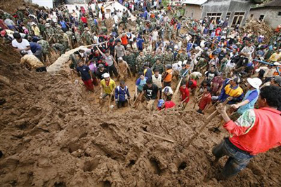
Landslide in Indonesia: seven dead, many more reported missing
Thanks to Alexandre Mathieu for the heads up on this landslide. A failure occurred yesterday on the island of Nias off the western coast of Sumatra in Indonesia. The landslide occurred as a result of heavy rainfall in Moze village in the south of the island. It is thought that 37 houses were buried.
To date seven bodies have been recovered, with estimates that up to a further 30 people may be missing. The image below (source) suggests that the landslide may have been an earthflow of some type.
http://www.brecorder.com/world/southeast-asia/37187-five-dead-30-missing-in-indonesia-landslide-.html
A rather less clear image has also been posted on this website, and suggests a quite long runout flow from a residual soil slope:
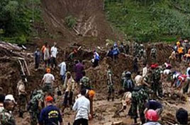
http://www.dayandnightnews.com/2011/12/four-dead-30-missing-in-indonesia-landslide/
30 November 2011
My AGU E-poster – The power law relationship for landslide fatality data
Summary: AGU have introduced an initiative that allows presenters to upload e-posters for the Fall meeting next week. This post provides access to my poster, which looks at the numbers of people killed by landslides worldwide .
This year, for the AGU Fall Meeting, which takes place in San Francisco next week, the organisers have provided a facility for those presenting a poster to make it available online as an e-Poster. This is an initiative that I really applaud as posters actually take a great deal of time to prepare, and frustratingly become obsolete at the end of the meeting. Being able to create a permanent record, and to provide access to the work from those that cannot attend, is quite a bonus.
I have a poster at the meeting entitled “The power law relationship for landslide fatality data”, which looks at whether there is a scaling law that describes the ratio of the number of people killed by landslides. This is best described by the famous Siphonaptera (Fleas) poem:
“Big fleas have little fleas,
Upon their backs to bite ’em,
And little fleas have lesser fleas,
and so, ad infinitum.”
In the case of landslides this says that for every very large landslide there will be many more medium-sized ones, and even more small ones, and even more very small ones, and that the ratio between the numbers is constant. This works very well for the volumes of landslides; my hypothesis in this research was that it would also apply to the number of people killed by landslides. In a nutshell, this is the case, but interestingly the nature of the ratio varies according to geographical (continental) area. I suspect that this is due to the factors that control this relationship, which may be partly physical (i.e. the size of the mountains, the amount of rainfall, etc) and partly human (the number of people per household, the size of villages, etc).
Anyway, the poster is available to view on the AGU conference website by searching on the author name (Petley) here. The file is in form of a pdf.
Needless to say I welcome your comments and thoughts on this initiative by AGU, the design of the poster or the science that it presents. I also hope that I will get to meet many of you in San Francisco next week. On a cold, wet and windy day in Durham, and whilst I am stuck on a train that is being delayed by a broken signal, the thought of being in California on Sunday is somewhat appealing!
29 November 2011
On seismic signals from landslides – new research
![]() Summary: new research from ETH Zurich on using seismic signal to detect large landslide events
Summary: new research from ETH Zurich on using seismic signal to detect large landslide events
Regular readers will be aware that in my view one of the most fascinating areas of landslide research at the moment is that of the seismic signals that they generate. Large, fast landslides, especially those formed from rock, are sufficiently energetic that they generate earthquake waves that can be recorded remotely. This provides an opportunity to detect large events as they occur and, potentially, to locate them. In addition, processing of the signal allows the speed of movement, and possibly other parameters to be determined. There are many applications of this, ranging from the academic (can we evaluate how many large landslides occur in an average year, and when and where do they happen?) to the practical (a well-developed system might give warning that a valley blocking landslide has occurred).
Of course all of this is in principle – in other words we think that landslide-induced seismicity has this potential, but the reality of making it work is yet to be completed. And hence the need for research.
Over at ETH Zurich, Jeff Moore and his colleagues have been working on this issue. Last week a paper (Dammeier et al. 2011) was posted online at the AGU journal “Journal of Gephysical Research – Earth Surface” that describes an investigation of these seismic signals, focusing on whether properties of a landslide, such as volume, can be derived from the seismic signals recorded remotely. To do this, 20 known rockslides from the Alps were compiled (including the 2004 Thurweiser rock avalanche shown below), and the data recorded in the regional seismic network analysed for each event.
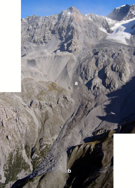
http://historyofgeology.fieldofscience.com/2010/09/18-september-2004-thurwieser-rock.html
The paper is interesting in a number of ways. First, it was clear that these events are indeed detectable and that they tend to have a characteristic spectrogram form that allows them to be differentiated from other events that generate seismic signals. The researchers also found that they could locate the events using the automated algorithms usually applied to earthquakes, with an average error of about 11 km. Of course, a circle of 11 km encloses a great deal of terrain, but nonetheless this at least gives a very encouraging starting point for finding the event. Hopefully with time this will be improved as better techniques are developed. Perhaps most usefully, the team found that simple metrics such as signal duration, peak value of the ground velocity envelope and velocity envelope area were correlated with landslide parameters such as volume, runout, drop height, and potential energy.
The research team then tested the resulting algorithm on three new landslide events, and succeeded in estimating key parameters to within an order of magnitude. There is at least one other interesting aspect. This is that the study starts to indicate a maximum detection distance for events if different sizes – so, for example, a one million cubic metre event can be detected for a little over 100 km. This suggests that to do this properly a quite dense seismic network is needed.
This study is a substantial step forward in this field, providing the quantitative reference algorithms that allow these analyses to be undertaken. It may well be that the relationships will need to be modified for other topographies, lithologies and land systems, so more work is needed in other mountain chains. However, the research validates the general approach, and as such is an important landmark. Hopefully it will stimulate more work in this important area. I hope that we’ll see more of this work by a variety of groups presented next week at the AGU Fall meeting in San Francisco.
Reference
Dammeier, F., Moore, J., Haslinger, F., & Loew, S. (2011). Characterization of alpine rockslides using statistical analysis of seismic signals Journal of Geophysical Research, 116 (F4) DOI: 10.1029/2011JF002037
28 November 2011
Funded academic and policy/enterprise fellowship opportunities at Durham
Summary: New funded academic opportunities at Durham!
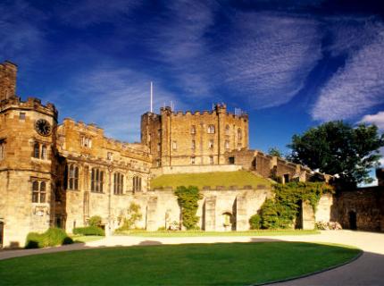
You've got to admit that it is kind of cool that we are a University with its own castle!
Here at Durham we have a number of funded opportunities for junior and senior research fellowships, covering both the academic and policy/eneterprise (i.e. non-academic) domians. These are great opportunities for people working in landslides, or in hazard and risk more generally, to come and work with us.
The opportunities are:
1. COFUND Junior Fellowships
This is the second round of the Junior Research Fellowship Scheme, designed to attract the most talented researchers in Europe and beyond, and to build international networks of scholars with a common passion for today’s most important research challenges. Up to 14 Junior Research Fellowships are available commencing between 1 July 2012 and 1 January 2013. The closing date for applications is 20 January 2012. Starting salary will be in the range £29,972-£33,734 p.a., with posts lasting two to three years. This scheme is for researchers with a PhD – in the first round most of the successful candidates had some postdoctoral experience, but this is not mandatory. Details are available here.
2. COFUND Senior Fellowships
This is the second round of the Senior Fellowship Scheme, designed to gather together scholars, researchers, policy makers or practitioners from around the world and across the full spectrum of science, social science, arts and humanities to address themes of global significance in collaboration with Durham’s Research Institutes and researchers. Two classes of Fellowship will be available in 2012-13: ten Senior Research Fellowships, which focuses on academics and seven Policy and Enterprise Fellowships, which focuses on those outside the academic community. These fellowship allow the recipient to spend between six weeks and six months with us at Durham. Details are available here.
Both schemes have some requirements in terms of the amount of time spent in the UK (essentially to encourage people from outside of Britain to apply), so the university is also offering three Policy and Enterprise Fellowships for UK-resident Fellows who do not meet the residency requirements for the above schemes. If you are based in the UK and are interested in one of these, please drop me a line as soon as possible.
Anyone interested in these fellowships is welcome to email me at: [email protected] I look forward to hearing from you!
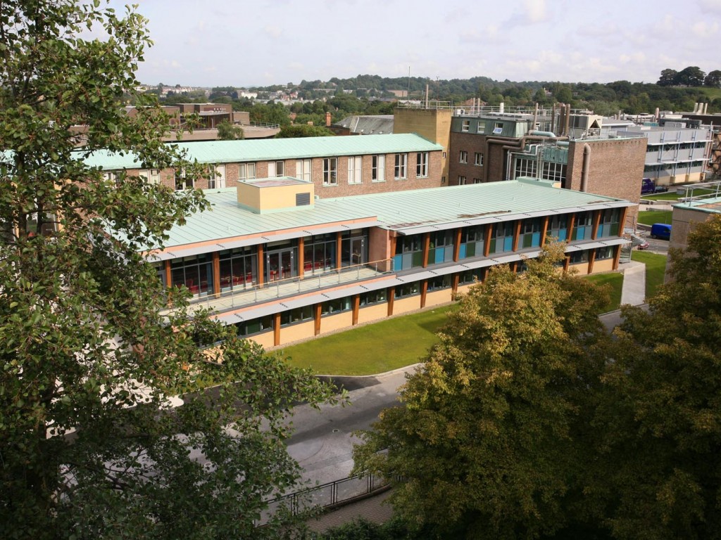
And this is our purpose-built Institute of Hazard, Risk and Resilience building.
26 November 2011
A summary of some recent landslide events
Summary: This post provides a round-up of landslide events that have caught my eye in the last week.
This time of year is the minimum point for annual landslide occurrence worldwide, with the northern hemisphere monsoon now completely withdrawn and the rainy seasons in the southern hemisphere yet to really start. Nonetheless a few interesting events are happening around the world:
A rare example of a beneficial landslide occurred at the El Dovio mine in Colombia, where a mudslide above an adit exposed a mineralization zone that is high in gold, silver and zinc content, increasing the reserves of the mine.
Meanwhile, there is an increasing sense of sympathy for the lone tree left isolated on the displaced block on the San Pedro landslide in California:

http://www.dailybreeze.com/news/ci_19409275
I am not sure whether it is possible to relocate such a tree, but getting to it would be rather risky. Unfortunately, it is likely that it has a short prognosis. Meanwhile, the article from which the above image is taken has a set of galleries of the landslide that are well worth viewing.
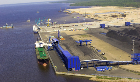
Elsewhere the picture is less rosy. For example, Russian media report that the new Ust-Luga Baltic Sea port on the Gulf of Finland was damaged by three landslides. Given that the images of the development of the oil facilities there suggest that this port has been constructed with extensive use of fill (see the image below – from this report), if the above article is correct then this is could well be a very serious problem:
http://swedish.ruvr.ru/2010/11/12/33590143.html
This is of course the perfect opportunity to replay the amazing Porto Cibatao landslide video from Brazil to demonstrate just how badly wrong things can go in such facilities:
http://www.youtube.com/watch?v=wS5TV5pFHOo
In Italy, heavy rainfall early in the week caused two landslide incidents. At Saponara in Sicily a mudslide killed a 10-year-old boy on Tuesday as his family fled their home. Later in the day it emerged that the same landside killed two men, a father and his adult son.
Over in Indonesia, heavy rainfall on Thursday evening triggered a landslide in Bogor that claimed two lives and left three people injured. Two of the survivors were reportedly buried for 20 minutes, which makes their survival somewhat fortunate. A similar event occurred in the Kilimanjaro area of Tanzania on the same day, reportedly killing a woman and her baby. And in China, a man was killed and two members of his family were injured in a landslide in Daning County, Shanxi Province. Earlier in the week, an 8-year-old boy was killed in a landslide in Catbalogan City in the Philippines. Three people were injured.
Finally the Nepali Times carries a detailed report on the state of the northeast state of Tapeljung, which was affected by the 25th September 2011 Sikkim earthquake. It is worth a look, not least for the images of the damage and the landslides:

http://nepalitimes.com/issue/2011/11/25/INTERESTINGTIMES/18754
The eport notes that “Two months after the earthquake, there is still devastation everywhere. Trails wiped out by massive rockfalls, schools and homes in ruins. We met families living in plastic tents provided by the Red Cross but as the winter approaches, the families fear the worst.” and “The earthquake completely destroyed 1369 houses in Taplejung displacing as many families. The official record also shows 56 school buildings, 7 police posts, 5 health posts and 9 other government buildings were damaged in the district. The locals say many destroyed school buildings including the ones that were constructed under the community supervision were of low quality and if the earthquake had struck during the school hours, lot of children would have died.”
I just hope that lessons are learnt from the severe impact of this comparatively small event, given the vulnerability of Nepal to a much larger earthquake event.
24 November 2011
A further update on the San Pedro landslide
Ernie Roumelis has very kindly sent me an update on the San Pedro landslide, which (with his permission) I reproduce here:
Approximate location is 33.715100°, -118.312185°. We have had some heavy rains over the weekend so a nice sized chunk of rock hastened its slip into the ocean last night. Here’s a video clip http://www.nbclosangeles.com/news/local/San-Pedro-Landslide-Cliff-134238418.html. I will look for more footage through the day. The local residents are notably upset. I wish there was a way to let them know that:
1) For the very long term, yes portions of the area could potentially be unstable.
2) No, they will not become an island like Catalina (located 35 km south of this region); and
3) Although Facebook is a wonderful medium for getting messages out quickly, one must take it all with a grain of salt and look a bit further when possible.
This area consists of a series of marine terraces unconformably sitting on Miocene sedimentary rock (Monterey Formation). The bedrock has been uplifted into an anticline and is now out-of-slope towards the ocean. Ancient landsliding occurred here during the Late Pleistocene and naturally stabilized. Local relative sea levels have also changed, partly due to Pleistocene-Holocene climate shift and partly due to tectonic uplift. As those sea levels have increased through the last several thousand years, the existing landslide toes slowly get eroded.
Every once in a while, another block slips along and falls into the sea. Last week’s sloughing was a part of that. To answer the newsperson’s question in the video clip, I am sure seasonal rains slightly help accelerate the process.
Here’s some more interesting information on this area. It has had documented movement since the late 1920’s. Most notably the Point Fermin landslide located 600m to the southwest. Here is a nice little virtual tour from Cal State Long Beach (one of the local universities) http://geology.cnsm.ad.csulb.edu/VIRTUAL_FIELD/Palos_Verdes/fermin.htm
Meanwhile, as Jim Heddingon pointed out in a comment, the Daily Mail has probably the best gallery of images of the landslide that I have seen to date, including this one:
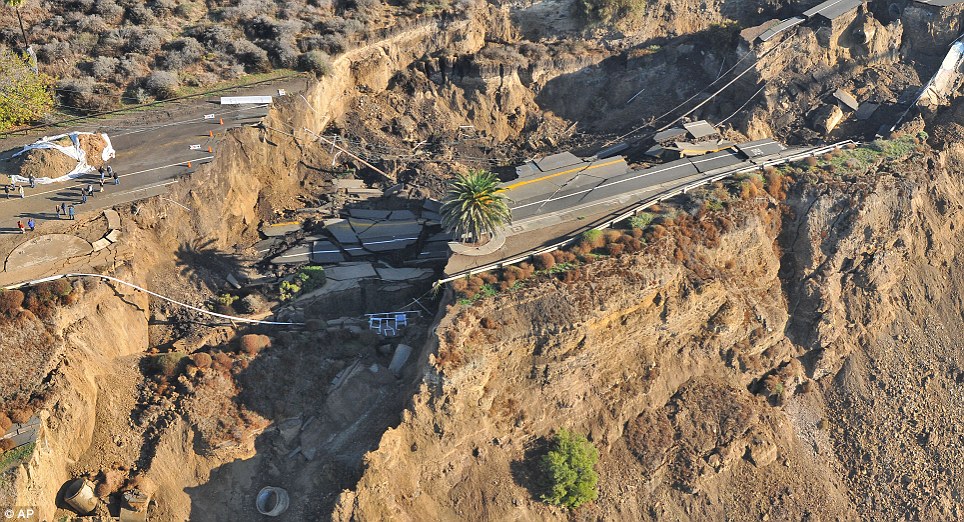
At some point in the next few months that large displaced block is going to collapse into the sea, which should be fairly spectacular.
 Dave Petley is the Vice-Chancellor of the University of Hull in the United Kingdom. His blog provides commentary and analysis of landslide events occurring worldwide, including the landslides themselves, latest research, and conferences and meetings.
Recent Comments