1 August 2012
An interesting landslide modelling post-doctoral position with NASA
This from Dalia Kirschbaum at NASA:
We are in search of a Postdoctoral Research Associate to focus on landslide modeling and hazard assessment. The position is at NASA Goddard Space Flight Center in Greenbelt, Maryland through an appointment at the Earth System Science Interdisciplinary Center (ESSIC) at The University of Maryland.
The post description is available at http://essic.umd.edu/joom2/index.php/employment/1096-research-associate-or-faculty-research-assistant
The position is to “research and programming support for a NASA/Goddard effort to develop, test and apply a global system for estimating landslides using satellite precipitation information, other satellite data and hydrological and land surface models. This is a great post with a world class team.
28 July 2012
Quite a cool new debris flow video from India
This was captured last month in India:
The text describes it as “The video was captured on June 24th 2012 as we were heading towards Manali from Kaza in Spiti via Kunjum Pass and Rohtang Pass along Chandra river. We were approaching Chhatru by afternoon. Approx. 5kms before Chhatru we saw the road had caved in due to a landslide.”
A landslide is rapidly destroying a World Heritage site in India
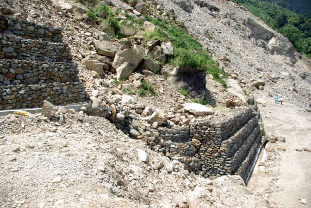
The ever impressive Save the Hills blog in India has a post including a set of images of a retrogressive slope failure in India that is threatening the railway shed at Tindharia. This is a railway settlement built by the side of the famous Toy Train – the Darjeeling Himalayan Railway (DHR). The DHR was constructed by the British back in 1881, and was designated a World Heritage Site in 1999/2000. The construction of this mountain railway is an astonishing achievement, and in this terrain maintain it is a very substantial challenge. Unfortunately, in 2010 the track was severed by a landslide at Pagla Jhora (picture by David Mead):
 The line is still blocked at this point. Then in 2011 another landslide severed the line at Tindharia (picture from Hari Pasod Sharma):
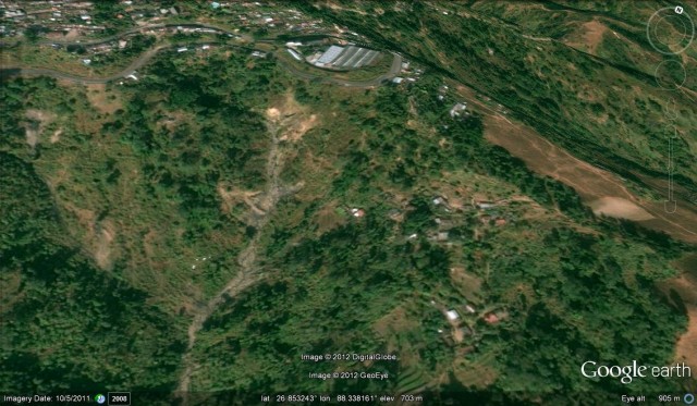
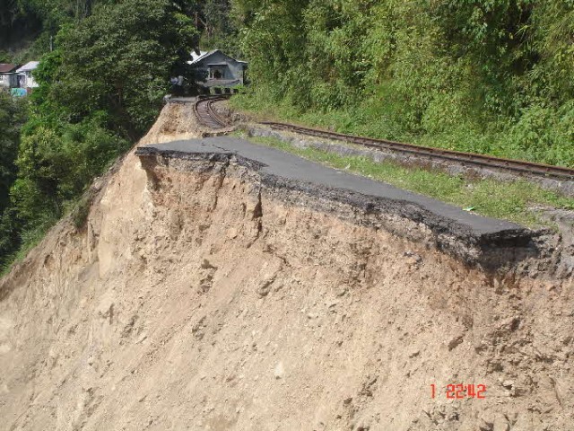 The result is that there is now no service on the upper parts of the line, with only a very limited service in the lower portions. This Google Earth perspective image from 2008 shows the Tindharia site quite well – the large building is the railway maintenance shed, with the line looping around it. The landslide has occurred in the heavily eroded terrain below the line:
 Unfortunately, on 19th-20th July 2012, the Tindharia landslide reactivated considerably during a heavy monsoon rainstorm, and has now removed both a substantial section of track and started to damage the walls of the shed. Save the Hills has an image of the site at the crown of the landslide:
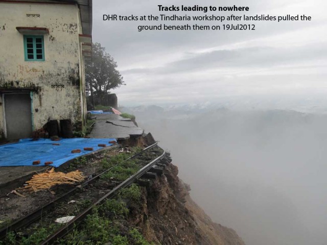 DHR has an overview of the landslide, showing the degree to which it has retrogressed in the recent event (the labels are theirs not mine):
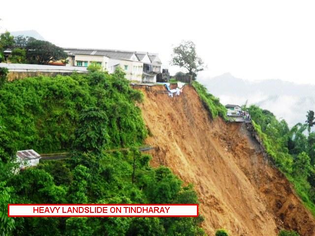 This is clearly now a crisis for the railway. Even without further retrogression (which does seem likely), the damage is now quite profound. Reopening the line will be exceptionally difficult without very large-scale engineering works. Further retrogression of the landslide will lead to the loss of these historic buildings. In turn, the landslide will be causing widespread economic costs through the region through the loss of both communication links and tourism.
This does seem to be an issue that deserves more attention. Your thoughts on possible solutions or ideas for mitigation are welcome.
27 July 2012
Landslides from the South Asian monsoon in 2012 to date
As anyone who has attended one my conference talks knows (see for example the slides here), the global epicentre for landslides that kill people is in South Asia, and in particular the southern edge of the Himalayan mountain chain. The key triggering mechanism is the SW (summer) monsoon, which brings prolonged rainfall throughout this region. The monsoon advance starts in late May, so at this time of year we are now two months into the monsoon period, which is a good time to reflect upon landslide impacts in this year’s monsoon. The graph below show the cumulative number of fatal landslides in South Asia for the last few years. The x-axis is time, shown here as pentads. A pentad is a 5 day period, so Pentad 1 is the period 1st – 5th January, Pentad 2 is 6th to 10th January, etc. The data is taken from Pentad 30 – i.e. day 151 of the year (31st May in case you are wondering) to Pentad 65, which captures the full period of the monsoon:
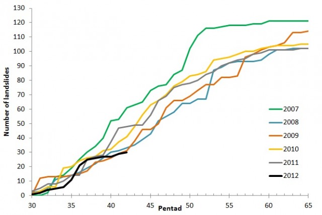 The black line is the 2012 data to date. You’ll see that it plots at the bottom of the distribution – i.e. at this stage in the monsoon we have the lowest number of fatality-inducing landslides seen in the last six years. Given the news of extreme weather elsewhere this might come as something of a surprise. However, so far for much of South Asia the SW monsoon has been exceptionally weak. The Indian Institute of Tropical Meteorology maintains a monsoon website, which provides data and maps of the monsoon through the annual cycle. This indicates that across India as a whole monsoon precipitation to date has averaged 295 mm, over 20% lower than the norm at this time of year (382 mm). The map of monsoon rainfall anomalies illustrates this really clearly:
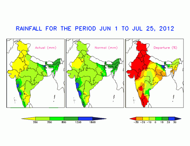 Interestingly, the map does suggest that at least eastern Nepal might have received greater than average rainfall, although I have no data to support this. Bhutan on the other hand, which is located just east of Nepal, does appear to have received unusually heavy rainfall so far.
Of course there is a long way to go in terms of the monsoon this year, and the above graph shows that the last year that started very dry, 2009, ended up with the second highest total on record. It is also worth noting that a very weak monsoon has other impacts too as agriculture across South Asia is critically dependent upon the rainfall that arrives in this period. The Indian government might declare an official drought next week. This might well represent something of a crisis in due course as food prices are expected to increase considerably in the coming months in response to the extraordinary, and rapidly intensifying, drought affecting the USA and Canada.
The amazing vanishing garden
Komonews ran a slightly perplexing story yesterday about a couple living in Whidbey Island, which lies a little to the north of Seattle in Washington State, USA. In the link there is a video that shows the rather interesting retrogressve failure that is steadily eroding away their garden. With luck and a following wind you might be able to see it below:
It is not at all clear to me why this should be happening at this site at this time. The owners describe a geysir 25 feet (about 8 metres) high, which suggests very high pore pressures developed in the ground at this location. This presumably indicates a change in subterranean plumbing, but the cause is far from clear. The process now appears to be a set of retrogressive failures that are slowly but steadily devouring the garden. There is a good article on the geology of Whidbey Island here – it is formed of glacial deposits that are likely to be highly erodible. Indeed, Whidbey Island has a long history of landslide problems, suggesting that one should not be too surprised that a failure can occur at this location. It is unlikely that the owners can do much except wait for the system to stabilise naturally.
24 July 2012
Breaking news – at least one person reported trapped in a landslide in Dorset, UK
Updates at the bottom of the post
Various news agencies are breaking the news that there may have been a major landslide at Freshwater Beach near to Burton Bradstock, in Dorset, SW England. The landslide reportedly occurred at 12:30. The ambulance service is reporting that at least one person may be trapped and that others may be missing. Search and Rescue teams, and helicopters, are on the scene.
Stories include the BBC:
http://www.bbc.co.uk/news/uk-england-18970361
And ITV:
http://www.itv.com/news/story/2012-07-24/freshwater-burton-bradstock-landslide-dorset/
Although news is currently very sketchy, the location is reported on Twitter to be close to the Freshwater Beach Holiday Park, which is I think this one:
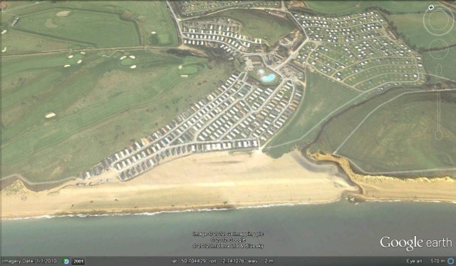 However, this is rather uncertain at the moment.
Updates:
15:16 BST: Suggestions are that the missing person is a 23 year old woman. Unconfirmed reports suggest that there may have been two landslides 20 minutes apart.
15:21 BST: Landslide reported to be 400 metres from caravan park
15:29: First image of the landslide. Looks like a large cliff collapse on to what may have been a busy beach on a very sunny day in the school holidays. With a bit of luck everyone got out of the way. Hopefully the apparent lack of urgency mens that no-one is trapped, but it could be that the site is considered to be too dangerous to enter
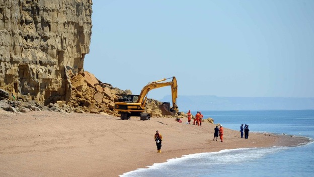 This site appears to the to the east of the caravan park in the sandstone cliffs.
Update 15:40 BST: Fire and Rescue services say at least one person is trapped, there may be others (hopefully not).
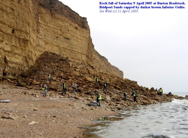
Update 15:47: Fantastic field guide to the cliffs here, by Ian West of Southampton University. We used to use the Bridport Sands from this location as the reference material for rock mechanics tests when I was doing my PhD. Rockfalls on these cliffs are very common. Ian has an image of a previous (2005) event on his website:
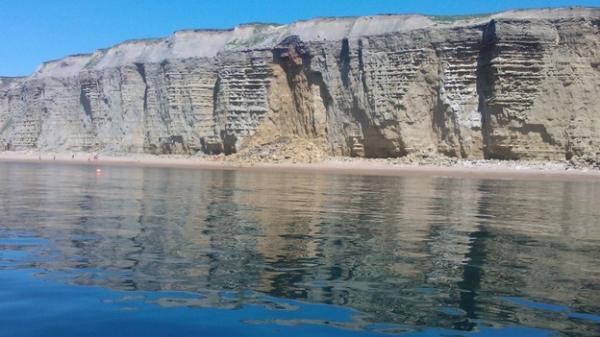
Update 16:24 BST: Dorset Scouser has some images of the landslide from the sea:
23 July 2012
A weekend of landslide incidents
This weekend has seen substantial landslide incidents around the world. Here are just a few of them, in no particular order:
1. An ongoing local landslide emergency in Quesnel, British Columbia, Canada
Thanks to Andrew Giles for highlighting this one. The town of Quesnel in British Columbia, Canada has declared a local state of emergency because of a landslide dam that is partially blocking a river, Baker Creek, upstream of the town:
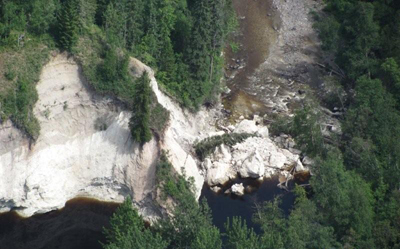 The concern is that the blockage could fail quickly, releasing a flash flood that would affect houses downstream. However, it should be noted that the dam is considered to be unlikely to fail rapidly, and trhat the peak flood is expected to be less than that experienced during flood season.
2. A landslide blocked the Trans-Canada highway near to Banff
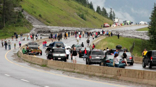
Meanwhile the very heavy rainfall in western Canada continues to induce landslides, with the latest occurring on Friday near to Banff. This time a large landslide crossed and blocked the trans-Canada highway close to Banff:
It is a little difficult to work out if this is a failure of the cut slope of a flow that has come down a gully, but either way the impact is clearly substantial. The road has now reopened.
UPDATE: Please see an account of this landslide on the blog of my fellow AGU blogger, Callan Bentley.
3. The cause of death in the Beaminster landslide, England
Meanwhile, the coroner in Dorset, England has released the cause of death for the two people killed in the Beaminster landslide in Dorset. It will be reassuring to all concerned that both victims died quickly. In fact, although there is remarkably little information available as to how victims actually die in landslides, these two victims do seem to have succumbed to what is assumed to be the two most common causes of landslide death. One victim was killed by a blunt trauma, in this case causing a broken neck, the other to chest compression. The implications of this are that the failure to realise that there was a car buried in the debris had no implications for the survival of the two unfortunate victims.
4. A landslide-induced fatal rail crash in India
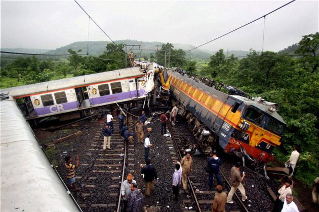
On Thursday night a train collision occurred near to Khardi Station in Kasara, India. The accident led to the death of a woman, whilst 14 others were injured. The initial cause of the accident was a boulder, which detached from an adjacent hill and rolled onto the track before striking a local train, which in turn derailed before being struck by the Vidarbha Express train.
5. A tragic bus accident in India
The worst accident was a bus crash near Keifang, about 100 km east of Aizawl, Arunachal Pradesh, when monsoon rainfall triggered a landslide that struck a bus on a mountain road. The bus was pushed off the highway and fell about 45 m into a deep gorge, killing 18 people and leaving another 17 injured. Sadly, such bus crashes are common in the Himalaya mountains.
6. A fatal landslide in Austria
On Friday night a rainfall-induced mudslide hit the village of Thoerl in Styria, Austria, killing a man. The mudslides were reportedly up to 10 m deep.
7. A fatal landslide in Mexico
Thanks to Lisa Denke for highlighting this one to me. A landslide in Mexico on Friday killed a truck driver (NB the image in this report, which is in Spanish, is disturbing). The landslide struck the truck close to midnight on the Durango-Mazatlan road, pushing the truck into the river.
8. A fatal landslide in Beijing, China
Beijing suffered exceptionally heavy rainfall on Saturday, triggering widespread floods. In the Shijingshan district a landslide on Saturday night buried a row of small shops, killing a couple and injuring a young woman, who was reportedly trapped for several hours.
9. Six killed by landslides in Sichuan, China
Finally, this report has rather sketchy information about six deaths from landslides triggered by heavy rainfall in Sichuan Province on Saturday. At present I have no more information about this event.
20 July 2012
Friday fun: So how does a landslide generate a tsunami? An amazing video of a collapsing glacier
Landslides are a key mechanism through which localised tsunamis can be generated, but it is very difficult to actually visualise this process. An amazing video has just appeared on Youtube that shows this process very clearly. The video is actually of a collapsing glacier in Greenland, shot from a boat. The event occurred at Ilulissat:
Obviously the main interest here is in the generation of the waves. The speed and violence of the waves is quite awe-inspiring given that the collapse is not huge.
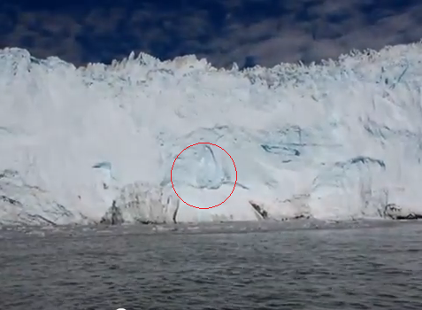
However, there is an additional aspect of this that is interesting. This is the way in which the glacier behaved prior to the collapse. Note that the video shows that the mass was generating small failures in the seconds leading up to the collapse, and that the rate of these increased just before the final failure. An example is highlighted below:
Similar behaviour is also seen for rockfalls and landslides, and is an indication that the creep rate is increasing, causing the mass to deform, which in turn pops off these little failures.
19 July 2012
Incredibly rare footage of a submarine landslide
Submarine landslides are poorly understood, in part because it is so difficult to capture them in real-time. This makes the following video, recorded at Cabo Sab Lucas, Baja California in Mexico, incredible valuable:
Hat tip to Pasi Jokela for highlighting this one.
New landslide video – Glacier National Park in Montana
Youtube has this video of a landslide this week in Glacier National Park in Montana. Note the rock blocks detaching from the main flow:
It appears that there is another video of this series of landslides as well, which apparently appears in this news report. However, I cannot get it to play on my PC.


 Dave Petley is the Vice-Chancellor of the University of Hull in the United Kingdom. His blog provides commentary and analysis of landslide events occurring worldwide, including the landslides themselves, latest research, and conferences and meetings.
Recent Comments