
5 October 2015
The seismically triggered landslide dam in Honshiyan, Yunnan, China: a review of a new paper
The Honshiyan landslide dam in Yunnan, China
On 3rd August 2014 a Ms=6.5 earthquake in Ludian County, Yunnan Province in China triggered a large landslide at Honshiyan, about 1.5 km downstream of an existing hydroelectric power station. This landslide blocked the Niulanjiang River, requiring emergency actions to drain the lake impounded behind the dam. In a new paper just published online in the journal Landslides, Zhang et al. (2015) examine both the emergency actions needed to mitigate the immediate threat and the potential for the use of the dam for hydroelectric power generation.
The emergency response to the Honshiyan landslide dam
Zhang et al. (2015) describe the parameters of the blockage – it had a volume of 12 million cubic metres, was 92 metres high, 753 metres wide and 283 metres long. However, the blockage was rather complex as it was formed from two different collapse events from each side of the valley, as shown in the images below from the paper:
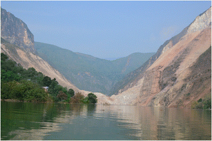
Panoramic view of the Hongshiyan landslide dam. This photo was taken upstream of the landslide dam (Zhang et al. 2015)
.
Analysis of the structure of the deposit suggested that it had a relatively high proportion of fine-grained particles as well as large boulders. Using a variety of analysis methods, Zhang et al. (2015) concluded that:
Based on the parameters of the Hongshiyan landslide dam and the field observations, the breaching risk of this landslide dam is located between the levels of “high risk” and “low risk”. Both the quantitative and qualitative rapid assessment methods indicate that the Hongshiyan landslide dam should be considered unstable.
In response, the authorities initiated the construction of a spillway across the landslide dam on 10th August 2014. The channel, which was 30 m wide at the top and 5 m wide at the base, was completed 11 days later This successfully prevented a dam break event. Thereafter, whilst the paper is a little unclear, it appears that a new tunnel was drilled into the mountainside to link to the existing diversion tunnel for the Hongshiyan hydropower station, allowing complete drawdown of the lake, as shown in the image (from Zhang et al. 2015) below:
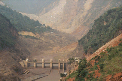
Water impounded in the dammed lake has been released by the new constructed channel. As shown in this picture taken on October 10th, the submerged artificial concrete dam has been exposed (from Zhang et al. 2015)
.
The use of the Honshiyan landslide dam for hydroelectric power generation
Interesting, because of the existence of the diversion tunnel, the Honshiyan landslide dam has the potential to be used for hydroelectric power generation. Zhang et al. (2015) have suggested that at a cost of between 1 billion and 1.5 billion RMB the landslide dam could be converted into a viable power generation site, generating a full return on investment in about four years. Thus, unusually, this landslide dam has the potential to generate long term economic benefits to the region.
Reference
Zhang, S., Xie, X., Wei, F., Chernomorets, S., Petrakov, D., Pavlova, I. and Tellez, R.D. 2015. A seismically triggered landslide dam in Honshiyan, Yunnan, China: from emergency management to hydropower potential. Landslides, avalailble online 23rd Septeber 2015, 11 pages,
3 October 2015
El Cambray Dos landslide in Guatemala: many killed
El Cambray Dos landslide
(I wrote this a few days ago but for some reason failed to publish it. I upload it here for information)
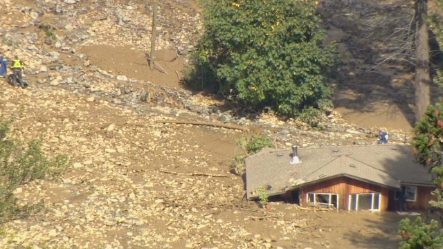
A very large landslide struck the small village of El Cambray Dos, near to Guatemala City, earlier this week, with catastrophic effects. Whilst there are wild variations in the loss estimates at present, the known death toll is at least 26 people, with an unknown number more missing. Whilst the images in the media are in general somewhat confused (and I suspect that at least some reports are using archive images from other events), the best sources of information on the El Cambray Dos landslide are first this image from the BBC:
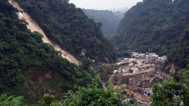
El Cambray Dos landslide from the BBC
.
And second this video from CONRED, shot I assume from a drone, that provides an overhead view of the landslide:
.
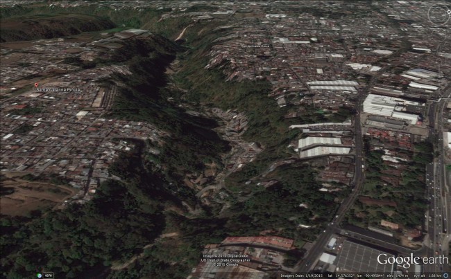
The El Cambray Dos landslide was apparently triggered by heavy rainfall. Judging by the above image, this is a slide in poorly consolidated, weak materials. I do not know much about the about geology of this area (can anyone comment?), and I am not having much luck in finding detailed information. As far as I can tell the landslide occurred at this location, in the incised valley at the centre of the image:
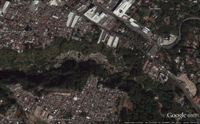
El Cambray Dos landslide site via Google Earth
.
This is a perspective view of the site, also from Google Earth:
El Cambray Dos landslide site via Google Earth
.
The combination of a deeply-incised valley, a meandering river that is actively eroding its banks, weak rocks and intense rainfall appear to be responsible for this landslide, although we will need further information to be sure.
In the last large El Nino in 1997 and 1998, Central and South America were badly affected by rainfall-induced landslide. Given the magnitude of the El Nino currently developing, the next few months would seem to be a period of high risk.
Acknowledgement
Thanks for Jose Cepeda for highlighting the CONRED information and for his thoughts on the event.
1 October 2015
Kothmale landslide in Sri Lanka: drone footage
Kothmale landslide
On 25th September 2015 a landslide triggered by heavy rainfall fit the village of Kothmale (sometimes spelt Kotmale) in Sri Lanka, killing seven people. There is good quality drone footage of the landslide in the first part of this video on Youtube:
.
And there is also some good ground based footage of the landslide in this video:
.
This is a screenshot from one of the videos of the landslide Kothmale:-
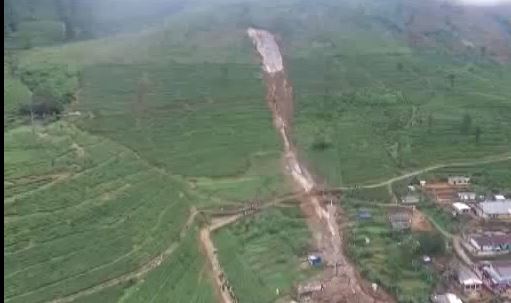
Kothmale landslide via Youtube
.
Whilst this the source area from the same video:-
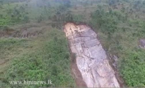
Kothmale landslide via Youtube
.
The main landslide appears to be a slip of a very thin layer of soil / regolith on a very steep bedrock interface. Note the soil layer at the top of the slope – it is possible that the slide started here and then entrained the regolith below. The landslide then appears to have turned into an open hillslope debris flow that has emtrained soil as it has passed through the tea garden. Sadly the houses in Kothmale were in the direct path of the flow, and would have offered little protection to the occupants.
30 September 2015
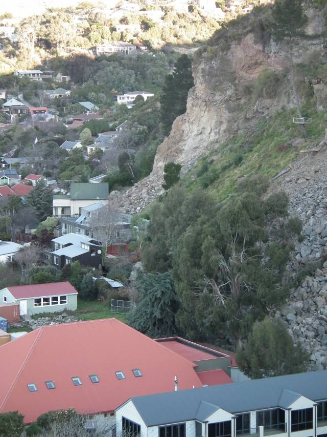
Rockfall and landslide damage in the Port Hills from the Christchurch earthquake sequence
Rockfall damage in the Port Hills
The media in New Zealand are reporting that, almost five years after the earthquakes, demolition has started on houses in the Port Hills area of Christchurch that were damaged by the 2010-1 earthquake sequence. Stuff.co.nz reports that:
“The first of a four-phase series of demolitions on the Port Hills has started. The Canterbury Earthquake Recovery Authority (Cera) is demolishing 16 red-zoned houses at Moncks Bay. Port Hills operations manager Brenden Winder said two properties at the top of the bay had already been cleared with two further properties at the bottom now being worked on. Demolition has begun on two red-zoned houses at Moncks Bay, Christchurch.Winder said potential rock fall, cliff collapse and landslips had made demolishing houses on the Port Hills significantly more difficult than in flatter areas. “Every property we deal with has a degree of risk associated and generally that’s very high. “It’s steep in there, access is constrained, there’s cliffs around, there’s broken retaining walls, there’s rockfall up above it and broken houses.”
The damage to some houses in the Port Hills area was profound. These are some of the photographs that I took after the earthquakes:
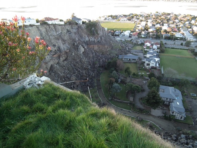
An example of a large-scale cliff collapse during the earthquake. Note the proximity of the boulders to the houses below
.
Some sections of cliff underwent extremely extensive failure.
.
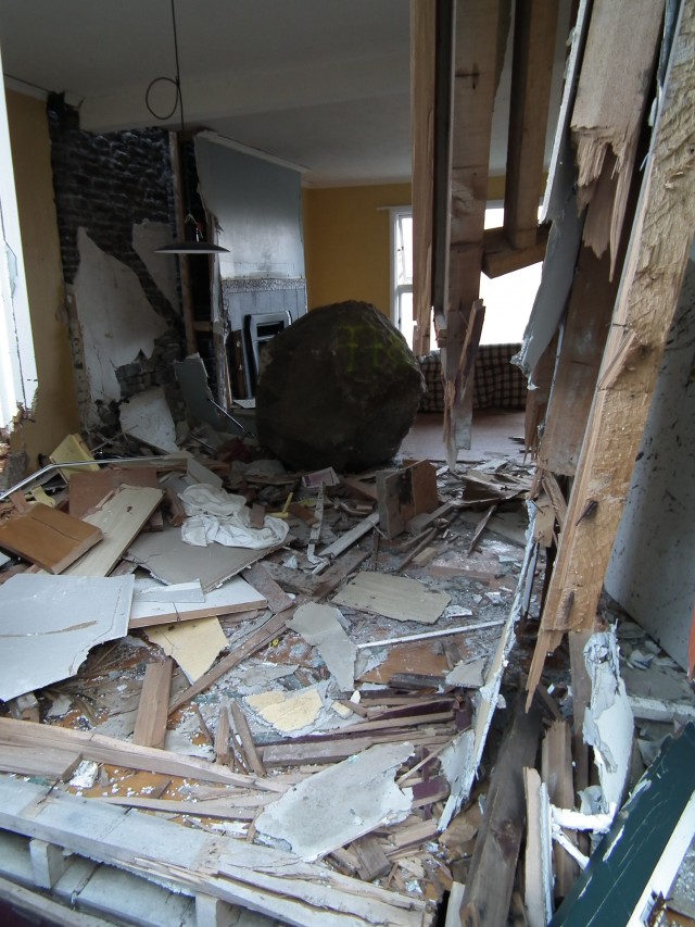
At the foot of the cliff problems ranged from large rockfall events to highly mobile individual boulders. The lightweight structures that are common in New Zealand provided little resistance to rapidly moving boulders in some cases.
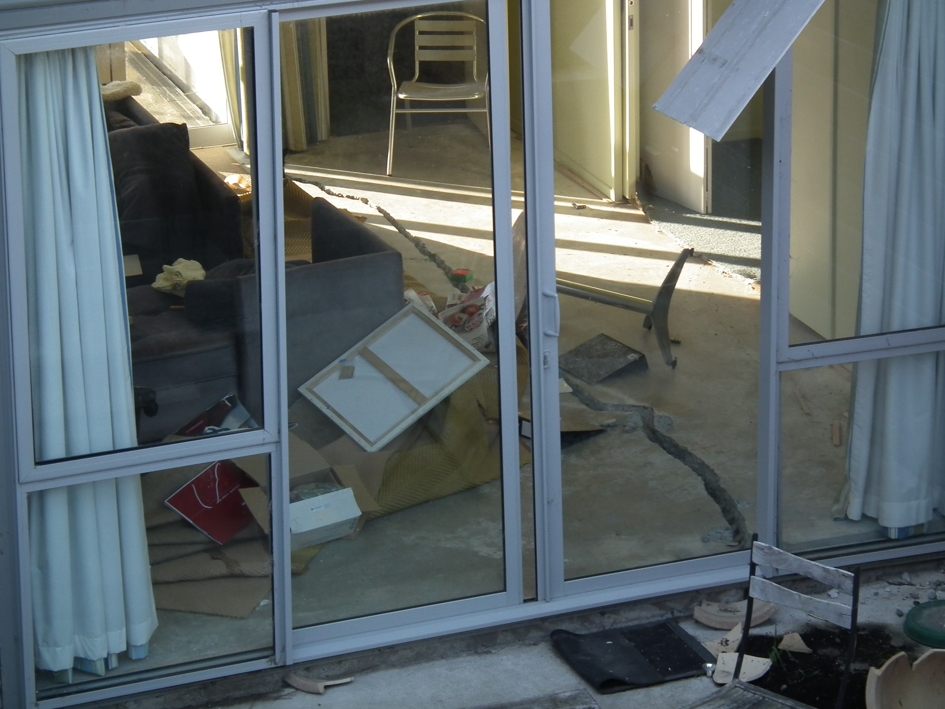
Buildings at the top of the cliff were also extensively damaged as the slopes moved below the foundations of the property
.
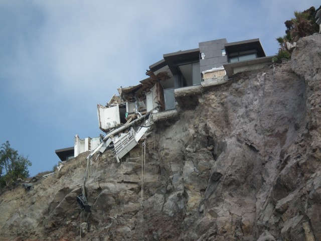
In some cases, the failure of large sections of cliff left properties in an extremely precarious position.
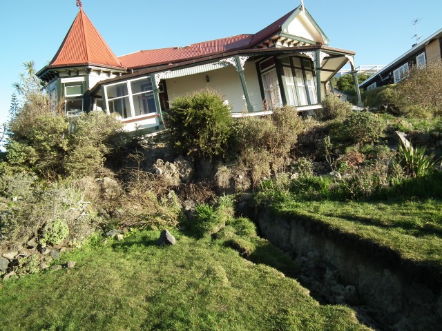
Movements in the loess capping at the clifftop generated extensive damage, causing the loss of some historic, beautiful properties.
.
Other posts that might be of interest:
- Rockfall risk assessment reports for the Port Hills, Christchurch, New Zealand
- The latest events in the Christchurch earthquake sequence
- Landslides from the Christchurch earthquakes part 5: landslides that involve sliding
- Landslides from the Christchurch earthquakes part 4: large-scale cliff collapses
- Images of landslides from the Christchurch earthquakes part 3: topographic amplification at the cliff tops
- Images of landslides from the Christchurch earthquakes part 2: evil dancing boulders
- Images of landslides from the Christchurch earthquakes part 1: boulder damage to a house
- Rockfalls from M=6.3 aftershock in Christchurch, New Zealand
- Rockfalls from the 2011 Christchurch earthquake
29 September 2015
The Inskip sinkhole in Australia – undoubtedly a landslide
The Inskip Sinkhole
The Inskip Sinkhole, as described in various media reports, developed on the Inskip Peninsular at MV Beagle Point, north of Rainbow Beach, on Saturday night:-
.
Descriptions of the event sound quite exciting, with a caravan, a trailer a car and some tents disappearing into the sea. Fortunately there was no loss of life. The best gallery of images of the aftermath can be found on the Sunshine Daily Coast website, from which this image is taken:
Inskip Sinkhole from the Sunshine Coast Daily
.
In the last couple of days the media have realised that this is not in fact a sinkhole, but is undoubtedly a submarine landslide. This report gets it right:
A Queensland Parks and Wildlife spokeswoman said the event was unlikely to be related to or caused by earthquake activity. “Rather, it’s most likely a natural phenomenon caused by the undermining of part of the shoreline by rapid tidal flow, waves and currents,” she said. “When this occurs below the waterline, the shoreline loses support and a section slides seaward, leaving a hole, the edges of which retrogress back towards the shore.”
This rather breathless report suggests that such events are not particularly uncommon on this section of coastline:
“A similar “sinkhole” event in the area was reported in 2011, and Rainbow Beach locals recalled “numerous” events.”
It would be fascinating to see some high resolution bathymetry data for this area as these slope failure events should leave a very distinctive deposit on the seabed. The above report quotes a local geologist, Ted Griffin, in explaining the phenomena:
“He said a large channel between Inskip Pt and Fraser Island regularly builds up a “shoulder” of sand, and falls away. “This is a big channel, perhaps 50 or 100 metres. It’s just a very unstable cliff of sand,” he said. “It seems to me very poor planning, that they’ve allowed development so close to such a vulnerable area.”
However, the exact mechanism of failure, and its causes, are not clear to me and would be worthy of further investigation.
27 September 2015
Tonzang landslide: a new giant landslide in Chin Division, Burma (Myanmar)
Tonzang landslide
Late in July extremely heavy rainfall affected Chin Division in Burma (Myanmar), triggering extensive landsliding and flooding. This event has been very little reported, but all of the indications were that the impacts were substantial. I have been trying to track down further information about this event ever since, and have now come across some information about it. In particular, it is now clear that the rainfall triggered what appears to be at least one giant (i.e. > million cubic metre) landslide. Whilst the area has been cloud covered since the disaster, Unosat have managed to obtain a partially cloud-free Pleiades image of the area, and have posted an interpretative image on their website:-
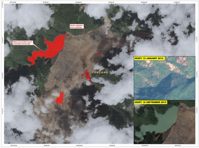
Tonzang landslide via UNOSAT
..
This is a very large landslide – the red area is the lake that has formed behind the landslide dam – this is 34 hectares in surface area according to UNOSAT. The part of the landslide that is visible here appears to be more than a kilometre wide and at least 3 km long. But note that all we are seeing here is the deposit – the track and source are somewhere beneath the cloud off the image. Colin Stark has very kindly overlain the image onto the Google Earth imagery of the area, giving an indication of the portion of the landside that we can see, and a symbol to indicate the likely source area:
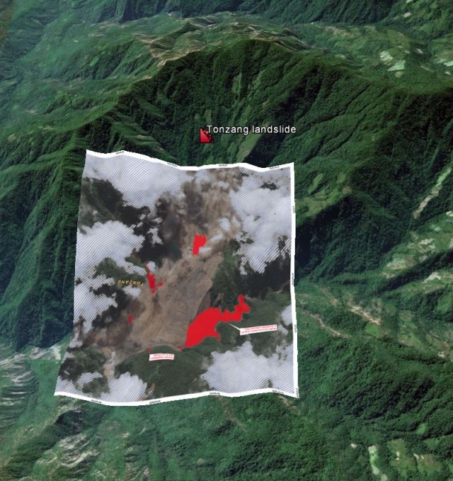
Tonzang landslide – UNOSAT image overlain onto Google Earth, courtesy of Colin Stark
.
As the monsoon withdraws the chances of getting a decent satellite image of the Tonzang landslide will increase, and this is a landslide on such a scale that it will be readily identifiable on Landsat 8, and suchlike. Watch this space!
Meanwhile, there is a blog featuring landslides in the Hakha City area of Chin Division, Hakha City, being run out of the USA. It has a fantastic selection of images of some of the landslides triggered by this heavy rainstorm event:-
Landslides in the Hakha City area of Chin Division via a blog
.
This area is 150 km or so south of the Tonzang region, so I don’t think the landslides featured here is that in the UNOSAT image. If so, it suggests that this was an extremely large landslide inducing rainfall event, probably the most important of the year to date.
25 September 2015
Landslides caused by beavers
Landslides caused by beavers
In Switzerland a section of the A1 motorway close to Courgevaux in the canton of Fribourg was closed by a landslide triggered by a beaver. Thelocal.ch has the details:
Several tonnes of earth and rock covered the roadway early in the morning and it took a crew with earth-moving equipment until the evening to clear it up, police said. The beaver had blocked a stream running parallel to the motorway. Pressure from the water burst a retaining wall, triggering the landslide, police said. There was no information on what happened to the beaver.
There is also an image of the debris:-
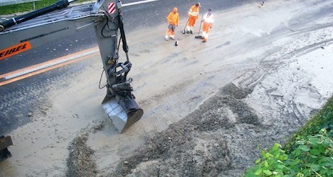
A beaver landslide, picture from the Fribourg cantonal police via thelocal.ch
.
Perhaps surprisingly this is not the first time that beavers have been responsible for landslides. Back in July, a landslide in Likely, British Columbia in Canada was caused by the collapse of a beaver dam. This landslide damaged a road, causing 14 properties to be cut off. Meanwhile, back in July 2014 beavers were initially blamed for causing a landslide in North Okanagan, also in BC, although after putting up a spirited defence they were subsequently vindicated.
Other posts that may be of interest:
- The sad tale of Maggie the Kakapo, the victim of a landslide
- Can toads detect forthcoming earthquakes (and landslides?)
- On the dangers of Rhododendrons!
- Now that is what I call a divot! An unusual hazard on a golf course in Switzerland
- A fatal rockslide in Switzerland with major economic impacts
- The remarkable Preonzo landslide in Switzerland last week
24 September 2015
The Pemberton Portage Road landslide in British Columbia, Canada
Pemberton Portage Road landslide
On Sunday 20th September, heavy rainfall induced a landslide in the town of Birken, north of Pemberton in British Columbia, western Canada. This landslide, which has become known as the Pemberton Portage Road landslide, appears to be an impressive flow type slide that caused damage to a house, a highway, railway lines and power infrastructure. Fortunately no-one was injured in the landslide, but of course the owners of the house are the real losers as it appears that, in common with many domestic insurance policies, landslides are excluded from their cover.
Yesterday BC Transportation tweeted this very impressive image of the landslide:-
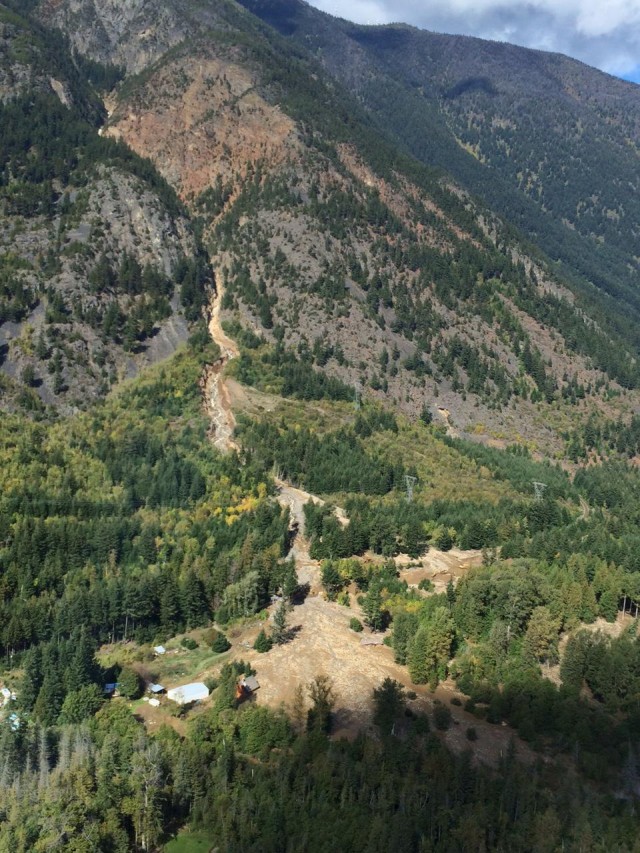
Pemberton Portage Road landslide from BC Transportation
.
The landslide itself is interesting. It appears to have started in the steep upper catchment, although the initial failure event is far from clear. It may well be a very small failure or even a temporary blockage in the channel. It then appears to have transitioned into a classic channelised debris flow. The middle part of the landslide track seems to show large amounts of erosion, suggesting that the landslide was entraining material to increase its volume.Deposition may well be controlled by a gradient change in the underlying topography. If you look carefully on the right side of the deposit the house that was destroyed can be seen, as shown in the CBC image below. Note that this is a two storey house, so the lower half of the house is completely buried:-
Pemberton Portage Road landslide from CBC
.
The best impression of the type of debris involved in the Pemberton Portage Road landslide can be gained from this short video of the immediate aftermath of the landslide, uploaded to Youtube by BC Transportation:-
.
Clearly this is not a mudflow per se (as the various articles are describing it), but technically it is a channelised debris flow.
There is now a fundraising campaign for the family – details are available on the Kelowna Now website. It is easy to forget the long term impacts of these types of landslides. There does seem to be a need to reconsider the lack of domestic insurance cover for mass movements in most countries.
Similar events that may be of interest:
- The 2011 Umyeonsan debris flows in South Korea
- Aerial images of the Izu-Oshima debris flows in Japan
- The June 2008 Lantau debris flow in Hong Kong
Another landslide in the Pemberton area (but somewhat larger!):
Acknowledgement
Thanks to Mika McKinnon for highlighting this landslide to me.
22 September 2015
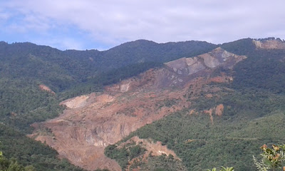
The 1991 Touzhai rock avalanche in China
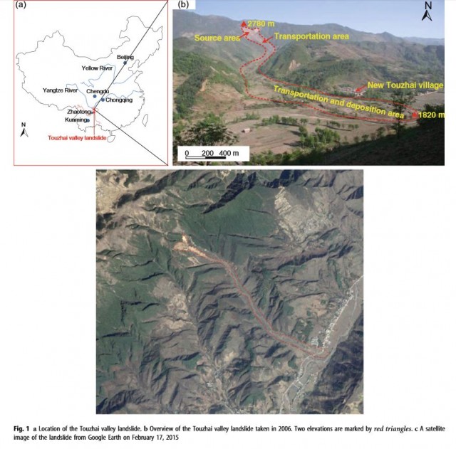
The Touzhai rock avalanche
On 23rd September 1991, at 18:10 local time, the catastrophic Touzhai rock avalanche occurred Zhaotong, Yunnan Province in SW China. This was a large event – the estimated volume of the Touzhai rock avalanche is 15 million cubic metres, and the landslide had a runout distance of over 3.5 km. After descending a vertical distance of about 950 m the landslide destroyed 202 houses in the village of Touzhai, killing 216 people. In a paper in the journal Landslides, Xing et al. (2015) (and with a stellar list of authors) have provided a detailed description of this landslide, and have modeled its movement using DAN-W software..
The landslide occurred after a prolonged period of heavy rainfall. Failure occurred on a steep slope in basalt over an area that was 900 m long (in terms of the slide direction) and up to 700 m, with a thickness of between 5 and 120 m. This is the headscarp are as shown in the paper:-
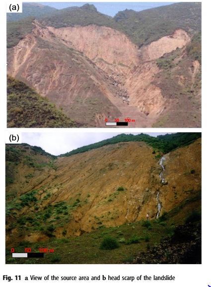
The headscarp of the Touzhai rock avalanche, from Xing et al. 2015
.
The structural control of pre-existing joints is quite clear. This looks to be a rather complex wedge type failure. This mass fragmented and transitioned into a rapid flow that travelled down the valley to hit the village below. The modelling of the landslide suggests that it had a peak velocity of just under 50 m/sec and an average velocity of 21 m/sec, giving a duration of the Touzhai rock avalanche of 175 seconds from the initial rupture event. This is the image of the landslide itself from the paper:
The headscarp of the Touzhai rock avalanche, from Xing et al. 2015
.
This landslide highlights one of the major issues managing the hazard associated with rock avalanches. The flow initiated in hard rock, but not on a near vertical cliff, over 3 km from the village. Identifying those areas that might be susceptible to such a failure is really difficult, and forecasting the likely runout speed and distance of the flow is also an enormous challenge. We still have a lot of work to do in this area, but detailed studies such as this are a great help.
Reference
Xing, A, Wang, G., Yin, Y. Tang, C., Xu, Z., and Li, W. 2015. Investigation and dynamic analysis of a catastrophic rock avalanche on September 23, 1991, Zhaotong, China. Landslides, 13 pages. Published online 11th August 2015.
21 September 2015
Human factors in landslide losses
Human factors in landslide losses
One of the aspects of landslides that we looked at it my recent paper with my Chilean colleague Sergio Sepulveda (Sepulveda and Petley 2015 – open access version) was the role of population density in determining landslide losses in Latin America and the Caribbean. For reference I described the main focus of this paper in a blog post a month or so ago. For those countries in the study area we looked at the relationship between landslide density (i.e. the number of landslides that caused loss of life per 1000 square kilometres and the population density for the country in question (using data from 2010, which is in the middle of the study period). We found a pleasingly strong correlation:-
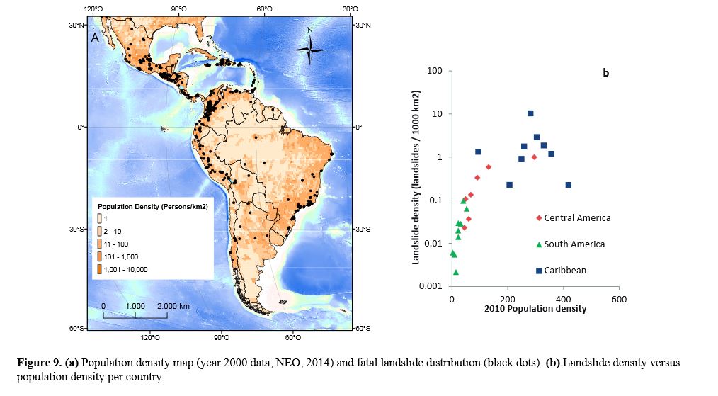
Human factors in landslide losses – Sepulveda and Petley (2015)
.
The graph is interesting for two reasons. First, it is clear that there is a strong correlation between landslide density and population density. Note that the landslide density is plotted on a log scale,suggesting that comparatively small increases in population density can lead to substantial increases in landslide density. The reasons for this are probably complex, but a key factor may be that there are simply more people in the landscape, meaning that any given landslide is more likely to cause a death. In addition, people themselves trigger landslides through slope cutting, deforestation and changes to the drainage network, amongst other things. It would be really interesting to examine this data in more detail to try to understand these factors properly – there is a great deal of anecdotal evidence about the role of human impacts on landslides, but few comprehensive, quantitative studies.
We also looked at the relationship between research and landslide losses, plotting the number of fatalities against the number of research papers on landslides over the study period:
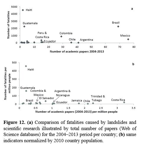
Human factors in landslide losses – Sepulveda and Petley (2015)
.
The volume of landslide research in this part of the world, as measured in scientific publications, remains depressingly low given the magnitude of the costs that they inflict on society. Whilst the number of papers from Brazil and Mexico looks impressive, when this is normalised by total population the data look much less impressive. But note that by far the largest numbers of fatalities in this region occurred in Guatemala and Haiti, and by any metric the amount of research being undertaken there is far too low. There is a drastic need to start to undertake more detailed work in these locations if we are to reduce the burden that landslides place on society there. And as the El Nino builds, the consequences of our failure to manage landslides properly in Latin America is likely to become all too obvious.
Reference
Sepúlveda, S.A. and Petley, D.N. 2015. Regional trends and controlling factors of fatal landslides in Latin America and the Caribbean. Natural Hazards and Earth System Sciences, 15, 1821-1833, doi:10.5194/nhess-15-1821-2015. The full paper available to download as a PDF.
 Dave Petley is the Vice-Chancellor of the University of Hull in the United Kingdom. His blog provides commentary and analysis of landslide events occurring worldwide, including the landslides themselves, latest research, and conferences and meetings.
Recent Comments