

28 October 2015
Landslides from the Afghanistan earthquake on Monday
Afghanistan earthquake
The M=7.5 Afghanistan earthquake on Monday was deep (the USGS estimates 213 km), meaning that it affected a large area of mountainous terrain. This is a zone that is highly landslide prone in even static conditions, so landslides were an inevitable consequence. In the aftermath a number of videos and images of landslides have appeared in various places.
Videos of landslides from the Afghanistan earthquake
This video shows a comparatively minor but visually dramatic terrace collapse in the Gilgit region of Pakistan:
.
This video appears to be a somewhat larger landslide, although I suspect that the nature of the material makes it appear worse than reality. It is certainly a very dramatic video:
.
This landslide is reported to have occurred in the Hooper Valley of Pakistan, again in weak materials:
.
Images of landslides from the Afghanistan earthquake
Meanwhile, there are also various images of landslides triggered by the earthquake. The ever-wonderful Pamir Times for example has this image of rockfall debris in the Gilgit Baltistan area:
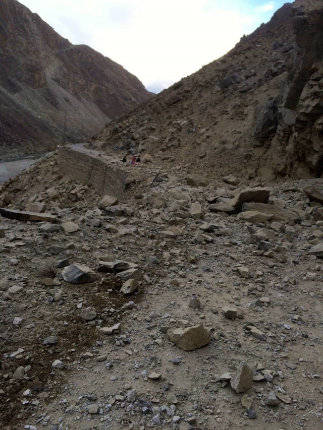
Rockfall debris in Gilgit Baltistan from the Afghanistan earthquake via the Pamir Times
.
Whilst landslide losses are a little unclear at the moment, the Pamir Times also reports four people killed in a rockfall on the Karakoram Highway. The level of damage to the road was clearly high, as depicted in this amazing gallery of images:
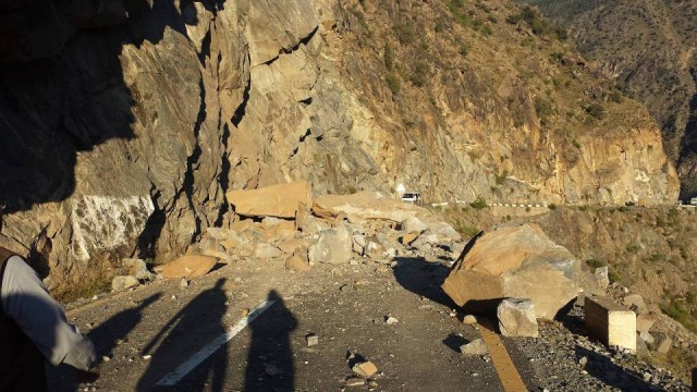
Landslides on the Karakoram Highway triggered by the Afghanistan earthquake, via the Pamir Times
.
The Chief of the National Disaster Management Agency in Pakistan is warning of the potential for further landslides in this area. This is good advice. The Daily Times reports that four members of rescue team were killed, and another 12 injured, in a landslide in the Kalam region of Pakistan yesterday.
It is worth noting that both NW Afghanistan and N Pakistan are hotspots for very large landslides in the uninhabited high mountain regions, many of which are triggered by earthquakes. It will be interesting to see whether any such events have occurred but have as yet not been observed.
23 October 2015
An astonishing new landslide video from an artisanal mine
A landslide in an artisanal mine in Colombia
An amazing new video has appeared on youtube showing a landslide in what appears to be an artisanal (i.e. small scale, unofficial) mine:-
.
The text on the original Youtube posting said:-
Unemployment forces these people to risk their lives every day in these mines. Just last Wednesday there was a large landslide that caused a great tragedy in the village of San Antonio in the municipality of Santander de Quilichao, in an illegal mine where gold is mined . This is due in large part to the neglect of the state, because the rulers are more occupied in their political confrontations in their own town
The video is dated 31st March 2015, which would mean that the landslide occurred on 25th March. But actually it seems more likely that this is the collapse that occurred on 20th April 2014. The reported death toll of this event was 16 people.
The truly horrifying danger of working in these conditions is all too clear, with the miners actively undermining the slope, in deeply weathered soil, in order to access the gold. The failure of the slope itself is rapid and catastrophic, and the rate at which the debris overruns everything in its path is remarkable:
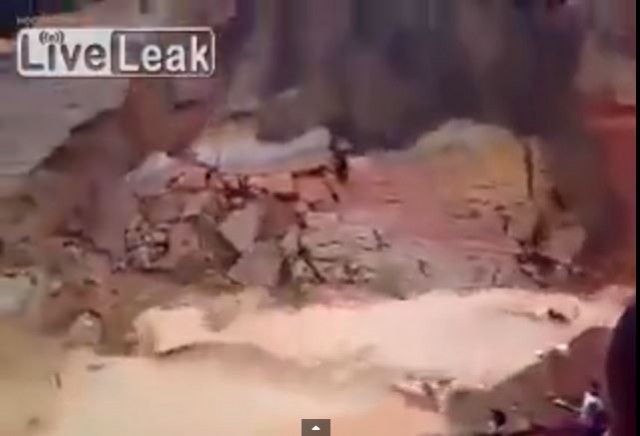
Landslide in an artisanal mine via youtube
.
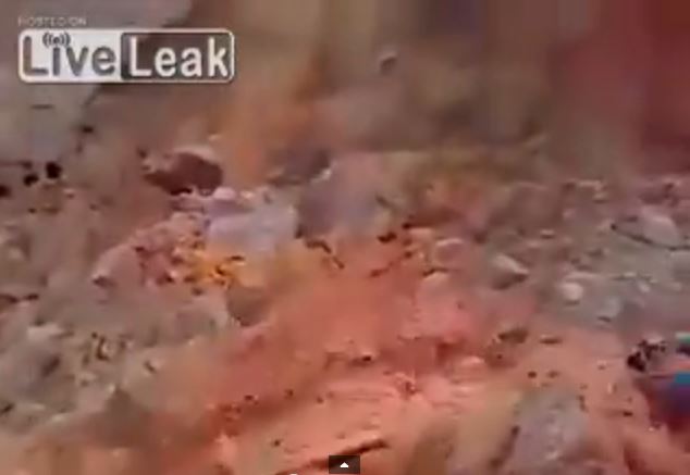
Landslide in an artisanal mine via youtube
.
The power of the displacement wave is also dreadful to behold.
20 October 2015
The Mount Steele rock avalanche: more details from the seismic data
The Mount Steele rock avalanche
Further analysis by Colin Stark and Goran Ekstrom has yielded more detail on the Mount Steele rock avalanche in the Yukon of Canada last week. This zoomed in perspective view of the satellite image provides greater detail:-
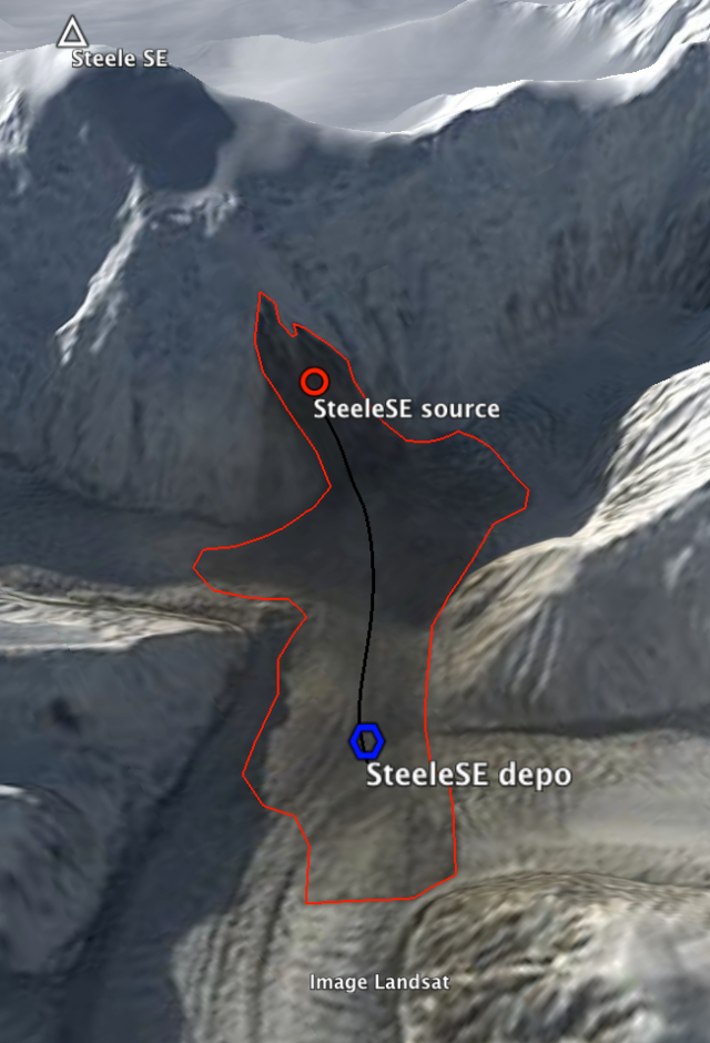
Landsat 8 image of the Mount Steele Rock Avalanche, provided by Colin Stark, with the landslide trajectory overlain.
.
The analysis now suggests a mass of the Mount Steele rock avalanche of 45 to 50 million tonnes, which would equate to about 20 million cubic metres, with a runout time of about 110 seconds. This is the velocity profile from the seismic data – note the comparatively rapid acceleration phase and a more leisurely deceleration:
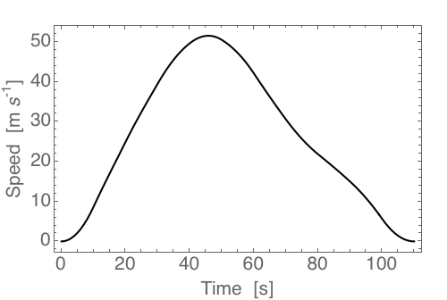
Velocity – time plot for the Mount Steele Rock Avalanche, provided by Colin Stark, deduced from the seismic data
.
Whilst this is a chart of the track of the landslide with the acceleration vectors overlain. The landslide starts in the bottom left corner on this plot:
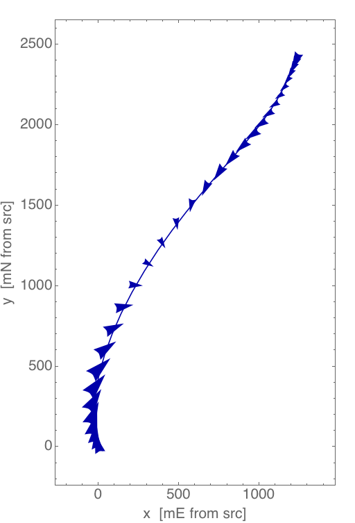
The planform trajectory of the Mount Steele Rock Avalanche, provided by Colin Stark, with the acceleration vectors overlain
.
And finally, this is the long profile of the landslide track from the seismic data. The arrows indicate the velocity of the landslide at each point.
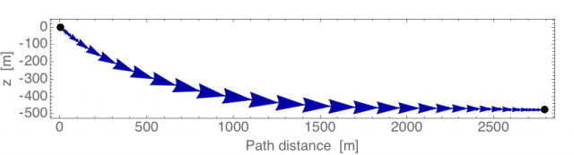
Long profile of the Mount Steele Rock Avalanche, provided by Colin Stark. The arrows indicate the landslide velocity.
.
Interestingly, this is second giant landslide in the St Elias area this year alone. On 11th August there was another event that dropped about 40 million tonnes of rock onto the Turner Glacier, not far away from this event. In addition, in July 2007 there was another large rock avalanche from the flanks of Mount Steele. This landslide, which is reported in Lipovsky et al. (2008) [note this paper is available online here], was even larger, with a volume of about 108 million cubic metres. This is an image of the landslide from the paper:
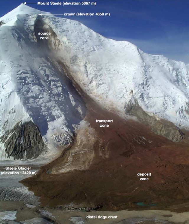
The 2007 Mount Steele rock avalanche from Lipovsky et al. (2008)
.
Reference
Lipovsky, P.S., Evans, S.G., Clague, J.J.., Hopkinson, C., Couture, R., Bobrowsky, P., Ekström, G., Demuth, M.N., Delaney, K.B., Roberts, N.J., Clarke G., and Schaeffer, A. 2008. The July 2007 rock and ice avalanches at Mount Steele, St. Elias Mountains, Yukon, Canada. Landslides. 5 (4):445-455.
19 October 2015
First announcement: a giant rock avalanche on the flanks of Mount Steele in the Yukon last week
Mount Steele Rock Avalanche
On 12th October at 02:02:32 UT a giant rock avalanche occurred on the flanks of Mount Steele in the Yukon area of Northwest Canada. The landslide was detected by Colin Stark and Goram Ekstrom of Columbia University using the global seismic network, and I am posting this news with their kind permission. Since the landslide occurred the availability of cloud-free satellite imagery has allowed the location to be identified.
The landslide is large – I will give the full details from the seismic inversion tomorrow – but Stark and Ekstrom estimate a mass of about 60 million tonnes, which yields a volume of about 24 million cubic metres. The crown of the landslide is at an elevation of about 3350 m, the total vertical distance is about 2200 m to the toe, with a runout over the Steele Glacier of about 3700 m.
Colin Stark has provided this Landsat 8 image of the landslide, draped into a digital elevation model. As can be seen below the landslide detached from the flank of Steele SE, a sub-peak of Mount Steele:
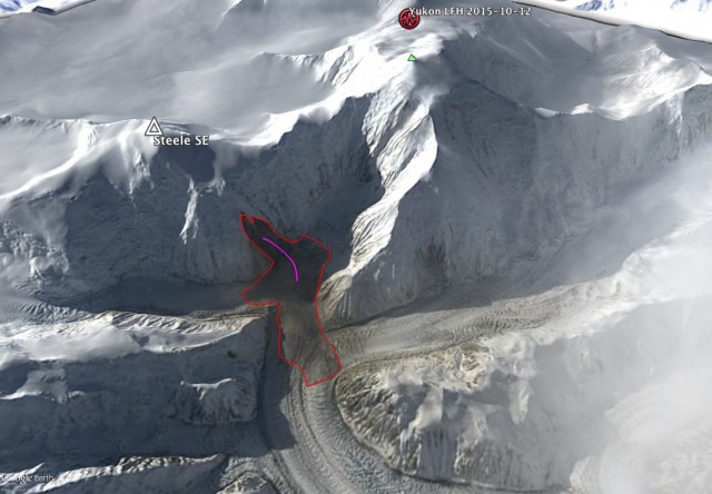
Landsat 8 image of the Mount Steele rock avalanche, courtesy of Colin Stark and used with permission
.
This is an image of the same location on Mount Steele before the landslide, also from Landsat 8 via Colin Stark:
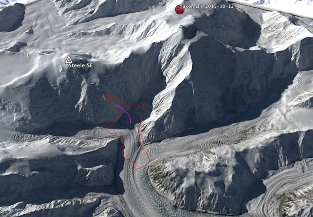
Landsat 8 image of the location of the Mount Steele rock avalanche, courtesy of Colin Stark and used with permission
.
Note the location of the landslide as indicated through analysis of the Landslide Force History (LFH) seismic data. This was within 7 km of the actual location of the Mount Steele rock avalanche, which is impressively close. The seismic data suggests that this rock avalanche had a peak velocity of about 60 m / sec, which is about 220 km/h. An interesting aspect of this landslide is the smooth morphology of the slope that failed compared to those around it, as seen in the above image. I am unsure as to whether this is significant.
I will provide more detail about, and further images showing, this landslide tomorrow.
18 October 2015
Videos and images of the mudflows in the Tehachapi Mountains, California
Mudflows in the Tehachapi Mountains
Exceptional rainfall on Thursday in the Tehachapi Mountains in California triggered a wave of mudslides that inundated Interstate 5 and Route 58, trapping a large number of vehicles. There is a really good set of images of the aftermath on Imgur:

Tehachapi Mountains mudflows via Imgur
.
The Weather Network has more details. Youtube has some good drone footage of the aftermath. The role of the concrete barrier in the median strip in containing the flows is very interesting. This probably provided a rapid way for the drivers to move to safety. I would be interested to know if this was intentional:-
.There are a few videos of the mudslides in action, such as this one:-
.
Probably the most exciting part though is this drone video of a mudflow sweeping down the valley:-
.
The impact of these flows on vehicles on the road is truly terrifying:
15 October 2015
Karachi rockfall: a human-induced tragedy?
Karachi rockfall
On Tuesday a rockfall occurred in a slum at Block 1 of the Gulistan-e-Jauhar area on the outskirts of Karachi, in Sindh Province, Pakistan. The landslide buried three small houses, crushing them completely and killing 13 people, including seven children. The National has a gallery of images showing the site of the landslide, including this one:
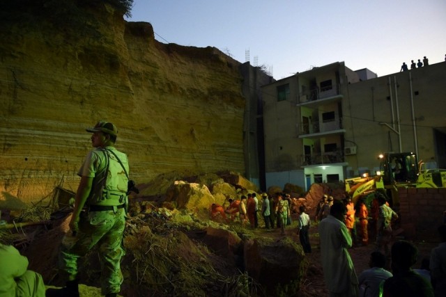
Karachi landslide via the National
.
A daytime image, also from the National, indicates what happened in Karachi:
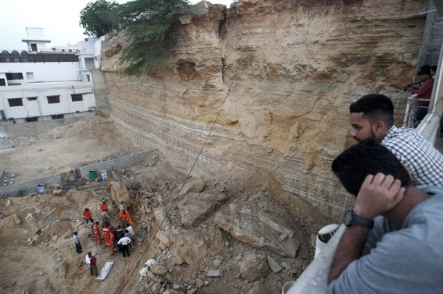
Karachi landslide via the National
.
It is clear that the toe of the slope has been extensively cut by a mechanical excavator – note the vertical scratches. The upper part of the slope has not been cut – I would guess that it was too high for the excavator to reach – leaving a large overhang. To the side of the landslide scar is a vertical joint that probably played a role in releasing the blocks. Note that the next section of the cliff, directly above the rescue workers, is highly dangerous. Thus, the indications are that this is a human-induced disaster.
Geo TV provides more information about the slope cutting:
Most land plots in the hilly area of Block 1 of Gulistan-e-Jauhar where the disaster occurred, measure 400 sq yards. The possible reason for the incident could be the attempt to increase the plots size to 800 sq yards. The process involved digging into the hill at its base, leading to its collapse, and a consequent landslide. Geologist, University of Karachi, Shamim Sheikh said the incident took place as a result of the digging into the hill at its base.
The plot where the incident occurred actually belongs to Ayaz Soomro, who is presently a member of Sindh Assembly and a leader of Pakistan People’s Party (PPP). Ayaz, son of Khuda Bakhsh Soomro, had received the plot number 64/13 in 1995.
Note that in the adjacent plot, visible in the first image above, the slope has been reinforced.
13 October 2015
The Deep Lake landslide in Montana
The Deep Lake landslide
The KPAX website has an interesting story this morning about the Deep Lake landslide in the Beartooth Mountains of Montana, USA:
The feature is an immense heap of rock, the result of a gigantic rockslide that formed a natural dam and created Deep Lake, one of the largest bodies of water in the Beartooths…Deep Lake is remote, but it is hardly unknown and it’s no secret that it was formed by a rockslide. Apparently, however, no one before Blevins—in consultation with Paul Burley, a geologist and civil engineer—attempted to estimate the total volume of the Deep Lake Rockslide…The slide is 1,100 feet (335 metres) deep at its apex and contains nearly 500 million cubic yards (383 million cubic metres), or about 1 billion tons, of material. By comparison, the Hebgen Lake Slide along the Madison River, which was triggered by an earthquake in 1959 and created Quake Lake, is estimated at just 43 million cubic yards. The Gros Ventre Slide, 30 miles east of Jackson, Wyo., is estimated at 50 million cubic yards.
“It does show that it’s huge,” Blevins said of their research into the Deep Lake Slide. “It’s just mind-blowing. We concluded that it’s probably the biggest in North America.” The second-largest slide in North America, Blevins said, is the Hope Slide in British Columbia. It comes in at 61.5 million cubic yards. The Deep Lake Slide, which is on the southern end of the Beartooth Plateau in Park County, Wyo., is thought to have occurred 10,000 to 12,000 years ago, at the end of the period of glaciation known as the Pinedale era. The slide dammed up Littlerock Creek, which gradually pooled to form Deep Lake, which is 1.6 miles (2.6 km) long and estimated to be about 600 feet deep (183 m). There is no surface drainage; excess water percolates through the slide, emerging downhill as large springs.
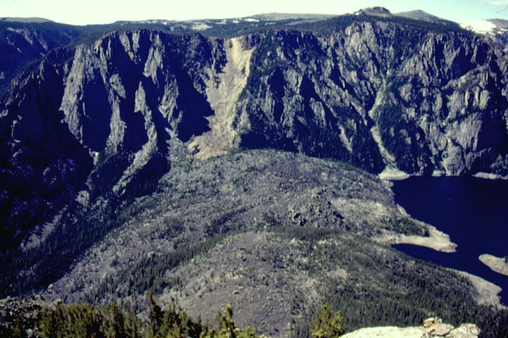
Deep Lake landslide – image from KPAX and Auzie Blevins
.
This is the Google Earth image of the Deep Lake site:
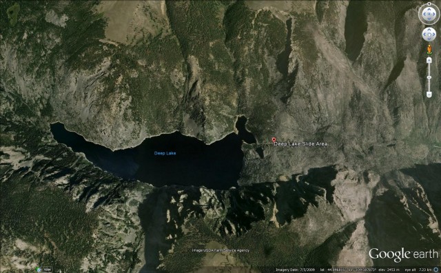
Deep lake landslide via Google Earth
.
The landslide is quite interesting from a morphological perspective – it is perhaps surprisingly large for terrain of this type for example. This appears to be the main source of the landslide and the deposit, again from Google Earth:
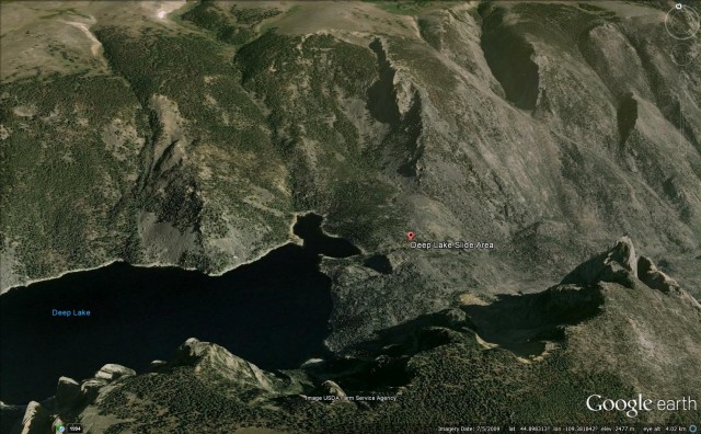
Deep lake landslide via Google Earth
.
But note that other areas, on both sides of the valley, have undoubtedly contributed volume to this landslide deposit.
The article argues that this landslide deserves more detailed study. Whilst the information about the largest landslides in North America is not correct – I looked at this issue in a post about the Bingham Canyon landslide in Utah two years ago – I can only agree that this landslide is worthy of a proper investigation.
11 October 2015
El Cambray II: 264 killed, 40 still missing
El Cambray II:
The Herculean effort to recover the victims of the El Cambray II landslide in Guatemala have continued for over a week now. Reports suggest that to date 264 bodies have been recovered, whilst the list of those missing has reduced to 40. To have recovered so many of the victims has required an enormous effort that is of great credit to those involved. This will have been an extremely difficult, dangerous and upsetting process.
The best update on the El Cambray II landslide that I have seen is in this Youtube video, which provides a time-dated overview of the recovery operations:
.
This map also provides a useful overview both of the location of the El Cambray II landslide, and those in the vicinity, compiled by Rüdiger Escobar Wolf of Michigan Technological University:-
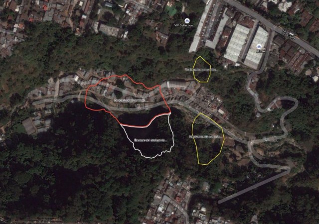
A map of the El Cambray II landslide, compiled by Rüdiger Escobar Wolf, Michigan Technological University
.
Perhaps the most interesting aspect of the video is the section, about 3 minutes 30 section into the video, that shows the landslide scar in detail:
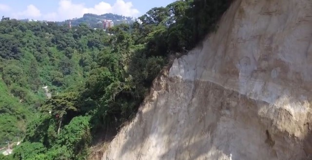
El Cambray II landslide scar, via Youtube
.
The very clear depositional change visible in the above image is particularly interesting. The scar is for the most part very planar and quite smooth (though now a little eroded by water). The other notable aspect is that the video shows the development of at least one new landslide during the recovery operations:
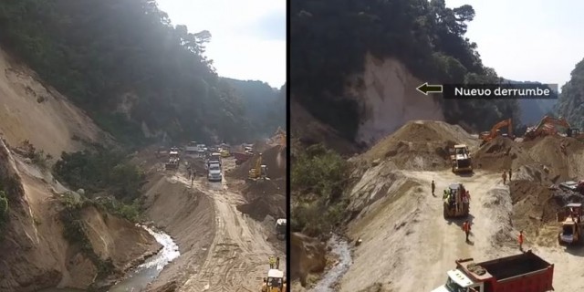
El Cambray II landslide from Youtube
.
This new landslide has probably resulted from the redirection of the river, which has caused undercutting of the slope. This is probably not surprising given the obviously erodible nature of the materials forming these slopes, and probably supports the hypothesis that this disaster was caused by the river eroding laterally into the cliff. Inevitably this raises serious questions about whether this valley, and others like it, are safe for human habitation.
Acknowledgement
Many thanks to Jose Cepeda of NGI for his help with this post.
10 October 2015
New landslide video: excavator earth slide
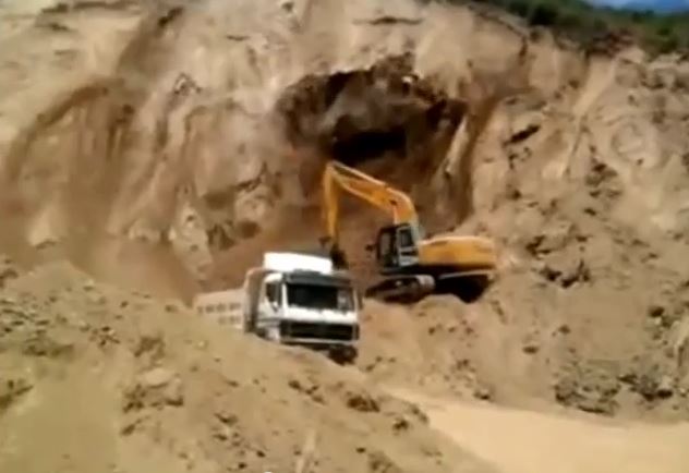
Excavator earth slide from Youtube
Excavator earth slide
The circumstances of this excavator earth slide are not clear:
.
It’s a nice illustration both of the effects of removal of toe support and of the development of failure though. Note how the removal of the toe of just a part of the slope has triggered much more widespread failure. It is also a really nice illustration of the development of a retrogressive failure.
The driver of the excavator was pretty cool in the face of the developing landslide.
8 October 2015
An account of the El Cambray landslide in Guatemala
El Cambray landslide in Guatemala
The Wall Street Journal has a nice article providing an account of the aftermath of the El Cambray landslide in Guatemala, as described by Sarah Sky, a US citizen who is teaching English at a school located opposite to the landslide site. This is an excerpt:
I awoke to texts about the incident, popping up at a rapid speed, in the group chat the teachers are a part of. Although an early riser, by 6 a.m. I already had a great deal of unread messages. It seems that Thursday night the mountain had shaken loose, the side of the cliff had toppled. There was a colony of about 150 poorly built houses located at the bottom of the ravine, with tin roofs and improvised doors, each one now buried under endless tons of dirt.
The news had startled me, but I wasn’t able to fully understand its impact until I arrived at work Friday morning and climbed the stairs to my classroom overlooking the ravine.
I heard the disaster before I saw it. The echo intensified the sound of the screams. The face of the cliff across from us had been green and now it wasn’t; that earth had been pulled by a gravity stronger than us into a place where it didn’t belong.
People milled around the floor of the ravine like ants, confounded in the face of the indomitable task at hand.
This is the view of the El Cambray landslide scar from her school:
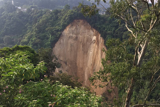
A view from the Sarah Sky’s school of the El Cambray landslide
.
Meanwhile, as the known losses extends beyond 220 people, with the total expected to rise substantially again over the next few days (up to 150 people are still missing, the UN is questioning whether corruption may have played a role in the El Cambray landslide disaster:
“What happened in Santa Catarina Pinula goes beyond a natural disaster”, said Valerie Julliand, resident coordinator for the UN System in Guatemala. …“Whether this institutional weakness is due to matters of corruption or to other causes, the result is the same. It affects human life,” Julliand said.
Julliand made the comments Wednesday at a press conference regarding funding for the UN-backed International Commission against Impunity in Guatemala (CICIG). The commission has played a key role in the investigation and prosecution of corruption scandals that brought down the administration of Otto Pérez Molina earlier this year.
Iván Velásquez, the former Colombian Supreme Court judge who now heads CICIG, also made reference to a connection between corruption and the deadly landslide.
“The population has understood that behind disasters like this one … behind the death of children due to hunger, behind the problem of the lack of education, behind the problem of medications, behind the miserable living conditions of so many millions, there is corruption,” Velásquez said Wednesday.
Interestingly the same report suggests that the site of the landslide was identified as being high risk in 2008 by CONRED, who restated this to the local authorities last year.
 Dave Petley is the Vice-Chancellor of the University of Hull in the United Kingdom. His blog provides commentary and analysis of landslide events occurring worldwide, including the landslides themselves, latest research, and conferences and meetings.
Recent Comments