
6 August 2014
Yunnan earthquake: images of the valley blocking landslides
Posted by Dave Petley
Yunnan earthquake
There is so much going on in terms of landslides at the moment that it is hard to know where to start! However, a key issue is the valley-blocking landslides and associated “quake lakes” triggered by the Yunnan earthquake of a few days ago. Yesterday, Xinhua posted a story about the impacts of landslides within the Yunnan earthquake zone that starts to shed some light on the issue:
Landslides have blocked roads leading to Longtoushan Township in Ludian County, epicenter of Sunday’s tremor, which killed at least 410 people and injured more than 2,300 others. A road leading to a large barrier lake on Niulan River was made passable after 38 hours of repairs by an armed police squad. Repair work is underway on three other roads in the quake zone.
As of 6 p.m. Tuesday, accumulated water volume of the barrier lake had reached 49.6 million cubic meters, and the water level is increasing at a speed of 16 cm per hour, said Sun Huaikun, a technical specialist in charge of the barrier lake response. Sun told a press conference late Tuesday that 4,200 residents living on the lower reaches of the Niulan River had been evacuated. A reservoir, located on the upper reaches, is required to intercept river water and reduce pressure on the barrier lake.
Barrier lakes, formed by landslides blocking rivers, are a recurrent threat to the lives of victims and rescuers alike. A 24-year-old border policeman is missing after he was hit by a falling rock as he attempted to swim a barrier lake in search of survivors. More than 60 soldiers were trapped by a sudden flood from a barrier lake Tuesday afternoon and were rescued by another team of armed police.
The most useful information though has come via tweet from Armand Vervaeck:
@davepetley – #Landslide #lake #earthquake Yunnan #China – Guess this page will be of interest to you! – http://t.co/rCpISFLqwP
— Armand Vervaeck (@ArmandVervaeck) August 5, 2014
.
The link is to a web page of the National Administration of Surveying, Mapping and Geoinformation, which provides a series of satellite images of landslides triggered by the earthquake. One of the images is this one of a valley blocking landslide:
 .
.
This appears to be a very large landslide dam that still has the potential to impound a great deal more water. The slide appears to have been quite mobile, showing signs of flowing down the valley (towards the left on the above image). If so, this should mean that the downslope gradient is less steep, which will reduce the chance of a catastrophic breach event. The landslide and lake have destroyed a large amount of infrastructure, including what appears to be a hydroelectric barrage and a bridge, judging by this before-and-after image pair from the same site:
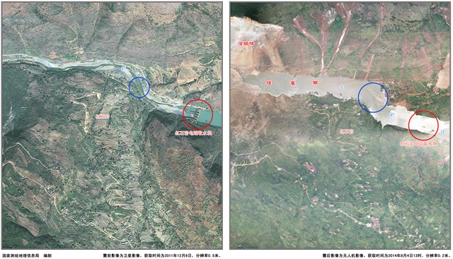 .
.
The site of this landslide is at 27.036 N, 103.409 E if you want to take a look on Google Earth. This is a perspective view of the landslide site:
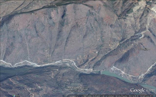 .
.
About 22 km downstream there appears to be a very large dam and long reservoir. This will catch the flood if a catastrophic breach occurs, so long as the water level can be drawn down in time. I would imagine that this is a very pressing imperative at the site at present. The timing of the earthquake, right in the middle of the monsoon, means that landslide occurrence will have been higher than would have been the case in the dry season and the rate of filling of the barrier lakes will also be high.
 Dave Petley is the Vice-Chancellor of the University of Hull in the United Kingdom. His blog provides commentary and analysis of landslide events occurring worldwide, including the landslides themselves, latest research, and conferences and meetings.