

2 January 2016
The Tyndall Glacier landslide in Alaska: the largest recorded non-volcanic landslide in North America
The Tyndall Glacier landslide in Alaska
An interesting story at the 2015 Fall meeting of AGU last month was the announcement by Colin Stark and Goran Ekstrom that they had detected an enormous landslide in Alaska, which I am terming here the Tyndall Glacier landslide. As regular readers know, Stark and Ekstrom have pioneered the use of seismic waves to detect very large landslides, with remarkable success. The Tyndall Glacier landslide occurred at about 8:19 pm local time on 17th October 2015 at the toe of the Tyndall Glacier. The landslide is enormous – Stark and Ekstrom estimate from the seismic data that it had a mass of about 180 million tonnes, which would give a volume in the order of 72 million cubic metres. The landslide flowed into Taan Fjord, triggering a localised tsunami that was detected 155 km away, according to the Lamont-Doherty press release.
Having detected the Tyndall Glacier landslide, Stark and Ekstrom located it with a very high resolution satellite image, which Lamont-Doherty have included in their press release:
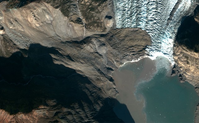
The 180 million tonne Tyndall Glacier landslide (NSF Polar Geospatial Center)
.
Note the large source area on the left side of the image, the presence of debris on the toe of the glacier, and the sediment charged water of the fjord. Most of the volume of the landslide must now be on the bed of the Taan Fjord.
The location of the landslide at the toe of the glacier is fascinating. As noted in the press release:
In the case of the Taan Fjord landslide, the Tyndall glacier’s retreat from the edge of Icy Bay in 1961 to its current location more than 17 kilometers up the fiord removed buttressing in the valley, leaving the weak rock on the valley wall prone to collapse, Ekström said. The entire valley was once filled with ice as much as 400 meters high, but as the glacier retreated, the ice thinned.
This mechanism of glacial debutressing has long been discussed by landslide scientist, and this appears to be a very clear example of the process. Given that the retreat of the glacier is being driven by the very rapid warming in the high latitudes, this is likely to be a response to global warming.
The press release also includes a before and after image of the tsunami triggered by the Tyndall Glacier landslide:
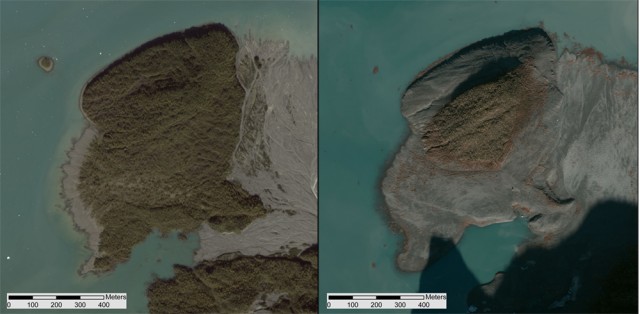
An island in Taan Fiord, about 10 km from the landslide, shown by satellite in 2014 (left) and a few days after the landslide and tsunami (right). (GeoEye, Colin Stark)
.
The waves triggered by the Tyndall Glacier landslide was clearly both large and very energetic to have caused this level of change. There is no doubt that this is an event that needs detailed investigation in the Spring. We can learn a great deal about both large landslides and landslide tsumani genesis from this event.
Finally, for now, at the time of the Bingham Canyon landslide in Utah we compiled a list of the largest known non-volcanic landslides in North America:
- Mt. Stellar AK – Sept 14, 2005 – 50 million cubic metres of rock and ice total, but initial detachment = 10-20 million cubic metres of rock.
- Mt. Steele Yukon – July 24, 2007 – between 28 and 80 million cubic metres including a “significant volume of ice”, modeled as 50 million cubic metres deposit.
- Mt. Meager BC Canada – 48 million cubic metres – 6 August 2010 – turned into 12 km debris flow, no deaths, ~largest in Canada.
- Hope slide BC Canada – 47 million cubic metres, January 9, 1965, 4 people killed – two seismic events noted, previous largest in Canada.
- Frank slide NWT Canada – Apr 29, 1903 – 30 million cubic metres – 70-90 deaths – Turtle mountain area today.
- Madison River Canyon (Earthquake lake) Montana – Aug 17, 1959 – 28-33 million cubic metres – 28 deaths.
- Lituya Mountain AK – June 11, 2012 – 5-60 million cubic metres – no deaths, poor volume estimate from deposit on glacier.
- Lituya Bay AK – July 9, 1958 – 30 million cubic metres – 5 killed from tsunami.
Plus Bingham Canyon itself, which had a volume of about 65 million cubic metres.
At about 180 million metric tonnes, this landslide had a volume of about 72 million cubic metres. On this basis the Tyndall Glacier landslide is the largest recorded non-volcanic landslide in North America. What a find!
24 December 2015
New landslide video: Ayacucho, Peru
New landslide video: Ayacucho, Peru
A video has appeared on Youtube showing a large landslide that affected a road in Ayacucho, Peru:
.
The landslide buried a pick-up truck – just visible at the start of the film and then being recovered at the end:
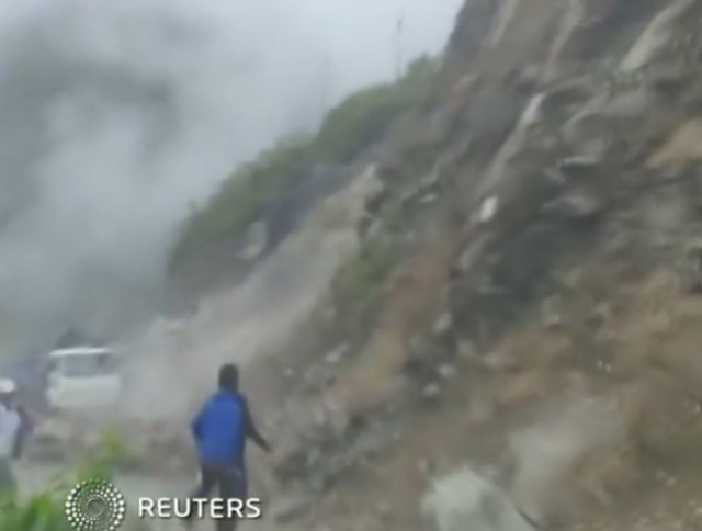
Landslide in Peru, via Youtube
.
The landslide happened near Tutumbaru in Ayna District, on the road between Ayacucho and San Francisco. Whilst the report with the video indicates that there were two fatalities, this newspaper article (in Spanish) indicates that this is incorrect, and only one death occurred – the driver of the truck.
23 December 2015
Videos of the Shenzhen landslide
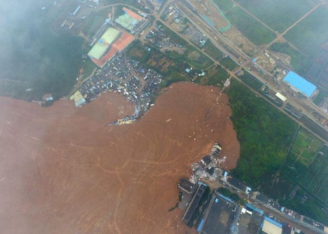
Shenzhen landslide via Xinhua
Videos of the Shenzhen landslide
As questions continue to be asked as to how the Shenzhen landslide, which is now thought to have killed 76 people, can have been allowed to happen, I thought it would be interesting to post a collection of videos of the landslide. Remarkably, one survivor was recovered today, and is expected to survive. Another man was recovered shortly afterwards, but died after being rescued. It is rare for people to be recovered from a landslide so long after the event.
Some of the most dramatic footage is of buildings being impacted by the Shenzhen landslide and then collapsing. The relentless power of the landslide is quite notable:
.
A different view captures both the advance of the landslide and the explosion of the major gas pipeline that was ruptured by the landslide:
.
This video captures additional footage of the exploding gas main and the landslide impacting the various buildings:
.
I have seen some discussion as to what this represents. I suspect it is simply that the pipeline had ruptured and a large volumes of gas was escaping. However, the landslide continued to move, so debris continually covered the ruptured pipe, causing the gas to burst through the sediment, creating this remarkable fountaining effect.
And this drone footage shows the aftermath of the landslide. The only mercy here is that the slide occurred on a Sunday, when the buildings were probably less densely occupied. If it had occurred on a work day then the losses could have been much worse:-
.
I remain intrigued by the material that forms this landslide. It has been repeatedly described as construction waste, but it is clearly not formed from demolished buildings. Indeed to me this looks to be excavated soil and weathered rock – take a look at the image below and the one at the top of the page:
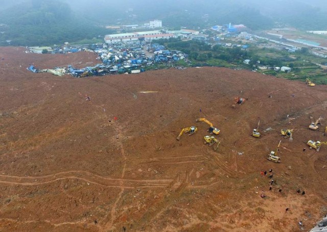
Shenzhen landslide via Xinhua
.
If I was investigating this landslide I would want to identify the very large excavations that must be ongoing in the city, or the surrounding area, to generate this amount of spoil. Interestingly, it appears that Shenzhen is extending its underground light rail system at present, with 87 km of new track. There has been some speculation that the two events might be connected, but I have no evidence at all to link them.
Finally, the very best collection of images that I have seen of the landslide are on the Getty News website, including a stunning aerial image looking along the length of the landslide. I cannot reproduce the image here, but it is worth a look on their website.
22 December 2015
The Shenzhen, Guangdong landslide: a massive flowslide in construction waste
The Shenzhen, Guangdong landslide: a massive flowslide in construction waste
The well-reported, enormous landslide in Shenzhen earlier this week was a most interesting, and of course deeply tragic, event. It is now clear that the Guangdong landslide was a very large flowslide from a pile of construction waste in a quarry above the industrial estate. Some reports suggest that there was heavy rainfall at the time. The Chinese news agency Xinhua has the best images of the landslide that I have seen to date, including this one showing the landslide mass and a part of the source in the background:-
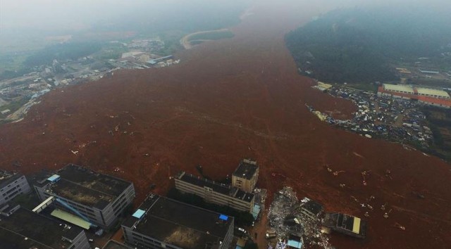
The Shenzhen, Guangdong landslide in China. Image from Xinhua,
.
As of this morning the number of people reported missing in the landslide is 85, with just one body recovered. There can be little hope of any survivors now. Xinhua reports that the landslide has covered an area of 380,000 square metres to a depth of 10 metres, giving a volume of 3.8 million cubic metres. This is an unusually large man-made slide. In essence the event appears to be almost identical in mechanism and outcome to a mine waste flowslide, of which China has had many of course. The best recent example is probably the Hpakant flowslide in Burma a couple of weeks ago, which also had a tragic outcome.
Of course in addition to the rescue operations, the focus is on how this can have happened. The International Business Times has a nice article that outlines the situation as of yesterday:
Residents told Xinhua the Hongao Construction Waste Dump had built up for nearly two years and stood at nearly 20 stories high when it collapsed. It also had overly steep slopes, making it unstable, the Ministry of Land and Natural Resources said. Documents published on the Guangming New District website showed officials had conducted monthly inspections of the dump, the South China Morning Post reported. In February 2014, officials gave the dump approval to operate for just 12 more months, but found in July — five months after it should have closed — that it was still in operation. At that time, the site was not following agreed safety or maintenance plans. Officials told the dump managers to improve its conditions and reapply for a license by September, which it also failed to do, according to the documents. “Illegal dumping of earth is strictly forbidden,” a statement in the documents said, according to the South China Morning Post.
The location of the landslide is 22.718, 113.933. There is excellent Google Earth imagery of the site. The most recent image of the quarry, taken on 29th September 2015, shows a large amount of dumped construction waste in the pit, retained by very steep, benched slopes:
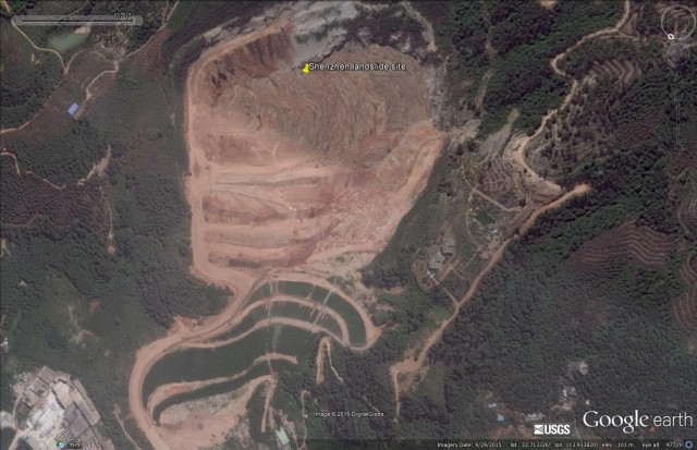
The Shenzhen, Guangdong landslide in China on 29 September 2015. Image via Google Earth.
.
This was quite literally a disaster waiting to happen, and there can be no excuse for this. Zooming back a year, this was the site on 23rd November 2014:
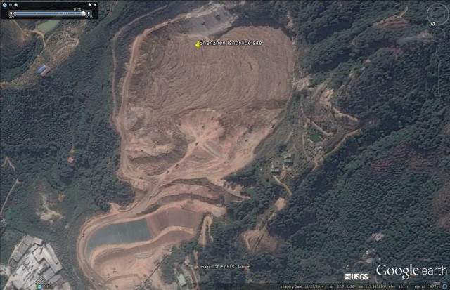
The Shenzhen, Guangdong landslide in China on 23 November 2015. Image via Google Earth.
.
Note the extensive work going on around the lower slopes. There are large numbers of dumper trucks hauling waste in this area. But a year earlier the site looks quite different. On 25th November 2013 the site was an abandoned, flooded quarry with no haul roads and no waste:-
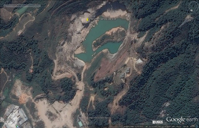
The Shenzhen, Guangdong landslide in China on 25 November 2013. Image via Google Earth.
.
It is notable that there is very little drainage evident in the debris pile in the most recent images. I suspect that a key part of the investigation may well be to ascertain what measures were in place to prevent the build up of excess pore water pressures in the spoil. The presence of water in the quarry before the dumping began suggests that the natural drainage through the bedrock was probably limited.
I would also draw your attention to one aspect of the most recent image that is not obvious at first inspection. The image is a composite, with the join running through the quarry. The more recent image is the lower portion – note the change in colour balance. I have drawn a line below to show the approximate location of the joint between the two images:
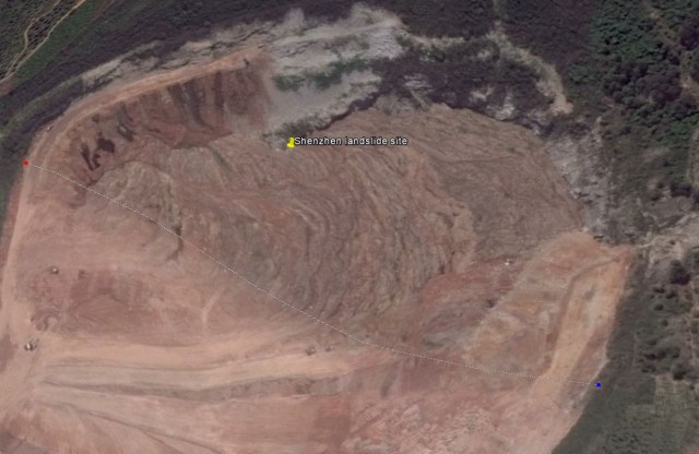
The most recent Google Earth image of the Guangdong landslide. The lower portion of this image is more recent, the line marks the point at which the two images are stitched
.
The lower (newer) portion of the image suggests that there was a new phase of dumping occurring on the waste at the very top of the slope, in effect to infill the remainder of the quarry. This will have steepened the waste pile dramatically, and may be the reason why the failure occurred now, rather than in the wet season.
I will post again tomorrow with a compilation of the amazing videos of the landslide event.
19 December 2015
Florence, Oregon: a fatal landslide triggered by intense rainfall
A fatal landslide in Florence, Oregon
At about 3:20 am on Friday morning a fatal landslide occurred near to Florence in Oregon. The landslide, which is described in some detail in an article in the Register-Guard, struck the rear of the house of a local resident:
At about 3:20 a.m. Friday, Dolores Miller heard clawing inside the back door of her Florence-area vacation home and went to let one of her two dogs out. And just then the home was hit by a lethal wall of trees, mud and other debris that cascaded from the rain-drenched adjacent hillside … Miller’s husband “heard a scream and he went to look for her and all the mud was in the house,” said Sean Barrett, fire marshal for Siuslaw Valley Fire and Rescue. The landslide filled the home of Miller and her husband, Gary, and knocked a neighboring home two feet off its foundation on Santa Road, a private road off Mercer Lake Road.
The article also has some images of the landslide, including this excellent picture of the source area:
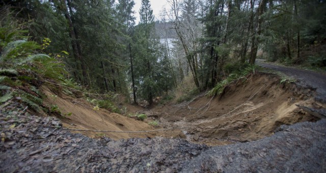
Florence landslide source via the Register-Guard
.
Whilst this image, from KATU2, shows the aftermath at the location of the house:
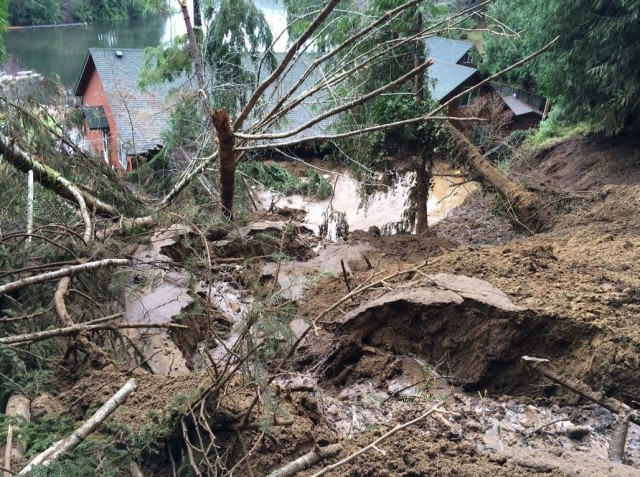
Florence landslide via KATU2
.
A very interesting aspect of this landslide is the fact that it appears to have initiated directly below the road. I suspect that those who are investigating this landslide will be interested to know whether the road was partially located on fill, perhaps to create a sufficiently wide road bench on the bend, and on how water was being managed around the road. But I have no indication that either of these things were a factor. The event certainly illustrates the danger of even quite small slope failures if someone is unlucky enough to be in the path.
This part of the USA is currently suffering very heavy rainfall, so the risk of landslides is perhaps unusually high.
17 December 2015
First news of a rock avalanche on Mount James Turner yesterday
Mount James Turner rock avalanche
Drew Brayshaw has tweeted this image of a rock avalanche that apparently occurred on Mount James Turner yesterday:
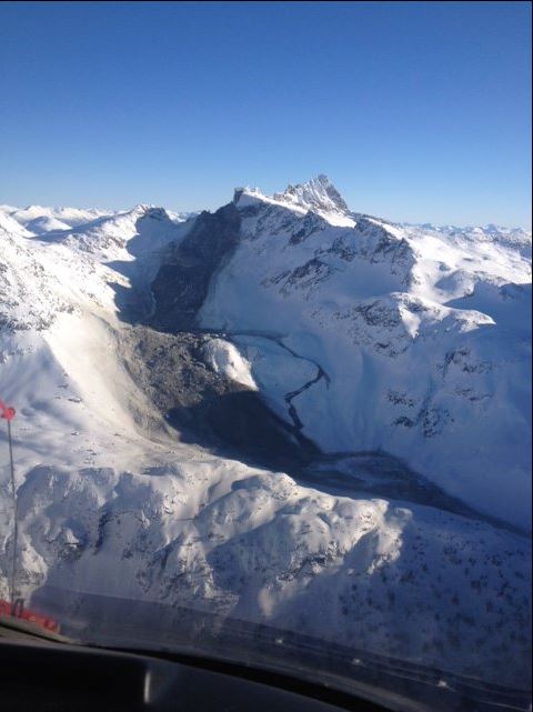
Mount James Turner rock avalanche via Drew Brayshaw and Twitter
.
Mount James Turner is close to Whistler in British Columbia, western Canada. This looks to be a large, very mobile rock avalanche event, with a steep upper portion and a long track. Note the small flow that appears to have left the main flow mid-track, and then rejoined the main flow after descending a step. There is some evidence of dust on the margin of the landslide. Drew also tweeted a pre-failure image of this part of Mount James Turner:
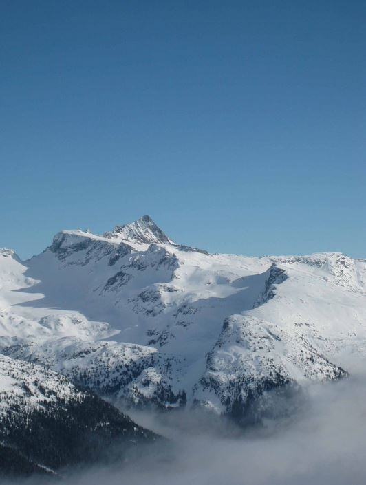
Mount James Turner via Drew Brayshaw and Twitter
.
The landslide appears to have originated from an unsually steep rock cliff on the edge of Fingerpost Ridge and will have had a substantial freefall element. Based on the image, and correlating with Google Earth, the runout distance that is visible will be about 2 km. However, there may be a longer non-visible component. The top of Fingerpost Ridge is at about 2600 m, whilst the foot of the steep slope is at about 2300 m according to Google Earth. The toe of the visible part of the landslide is at 1900 m.
Interestingly, at the toe of the landslide there appears to have been a lake – named Berna Lake:
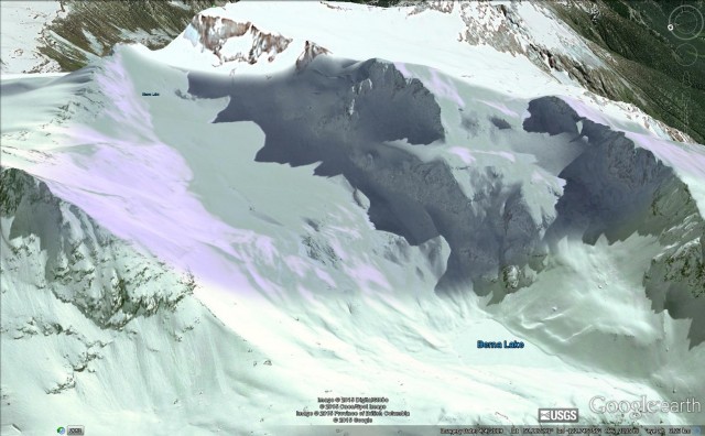
Mount James Turner via Google Earth
.
Is this the snowy apparently-deformed mass that appears to lie at the toe of the landslide in the first image? Canada has a good seismic network, so it will be interesting to see if this landslide has been captured on those sensors.
16 December 2015
Burma jade mine landslides: an annus horribilis
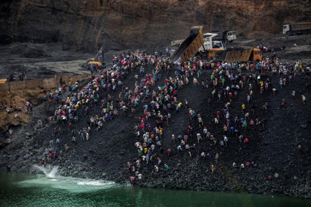
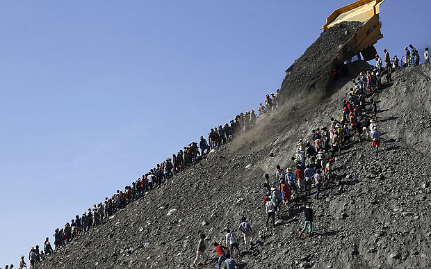
“Small-scale miners search for stone as dump trucks from Myanmar Sein Lei Aung mining company dump waste in Hmaw Si Zar, Lone Khin, Hpakant, April 2015”. These dumping operations are the major cause of the Burma jade mine landslides. From Time Magazine
Burma jade mine landslides
Yesterday there were reports of yet another landslide in the jade mine area of northern Burma (Myanmar). This time the landslide appears to have killed at least one person, with a further ten missing. If these individuals were buried then the likelihood that they survived is very low. Whilst reports are sketchy, it appears that this was another collapse of a waste pile onto informal miners who scavenge the dumps:
The Irrawaddy news service cited a police officer Tuesday as saying that one person had been confirmed dead since the collapse of a dump pile in La Mong Kone village of Hpakant township the day before. “The landslide moved slowly, so most of the people working on the waste pile had time to run for their lives,” he said. “According to witnesses, he fell down from a cliff and was buried deeply,” he added, warning of the threat of more landslides in the area. Khin Maung, a miner who witnessed the collapse, told The Irrawaddy that around 20 people had been mining for jade residue at the time of the incident. “The waste pile slowly slid down, with people shouting and running away. Some escaped, but some did not,” Khin Maung added.
Irresponsible dumping may be the cause of Burma Jade mine landslides, from the Telegraph
The Hpakant area of Burma has suffered a string of major landslides this year, including the following prior to the most recent event:
| Date | Location | Fatalities | Injuries |
| 06/01/2015 | Hpakant town | 2 | |
| 08/02/2015 | Hpakant town | 4 | |
| 06/03/2015 | Maw Mau Layang, Hpakant town | 24 | |
| 30/03/2015 | Hpakant town | 30 | 2 |
| 09/04/2015 | Lonekhin village, Hpakant town | 70 | |
| 20/11/2015 | Sankhatku village, Hpakant town | c.214 |
Over 300 fatalities in a year is a truly dreadful toll for a hazard that should be entirely avoidable. A key question is why Burma has suddenly started to suffer such huge losses. Has something changed, or could it be that only now is information about the level of loss becoming apparent. The answers lie in a fascinating article on the Human Rights Watch website:
The miners were working at a site used by dozens of Burmese and Chinese companies that have dramatically increased mining in the past year, driving many small-scale miners to scavenge for small jade deposits the machinery misses, in dangerous dump sites where landslides are common. Since large-scale mining resumed in 2014, profits have skyrocketed, but that has done little to reduce the threats to miners’ safety.
Unfortunately until safety at the mines in Burma is addressed, landslide losses will continue at this rate. It is tempting to blame the illegal miners scavenging the waste dumps, but the reality is that it in incumbent on the mining companies to make their operations safe.
15 December 2015
Tillamook in Oregon: crowd sourcing a landslide repair
Tillamook landslide in Oregon
Near to the town of Tillamook in Oregon a small group of householders has suffered the nightmare of discovering that their properties are built on or close to an active landslide. The slide appears to have activated during the recent exceptionally wet weather, to devastating effect. This is I believe the collection of houses, as shown on Google Earth:
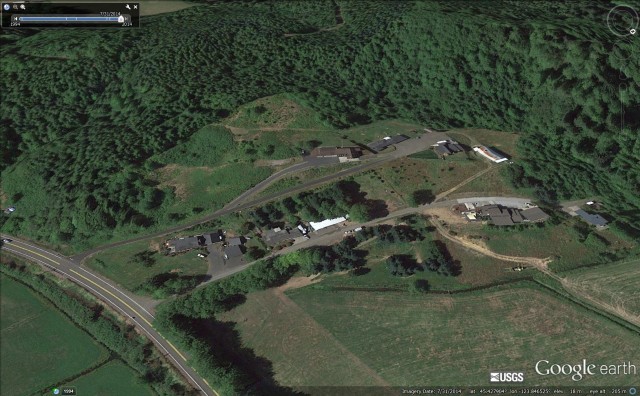
Tillamook landslide via Google Earth
.
The active landslide is not apparent on this image, though the steep back scarp and hummocky deposit hints at previous movements, perhaps. The recent movement is large – this image from KOIN6, shows the surface displacement on a section of the landslide:
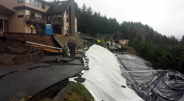
Tillamook landslide via KOIN6
.
As usual to really understand this landslide we need an overview image. So far I haven’t been able to track down a good one, this is the best I can find:
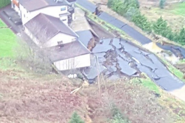
Tillamook landslide via Morgan Kottre
.
The amount of displacement on this landslide is impressive. The various images seem to indicate that it may be retrogressing. It appears to be dominantly translational – there is perhaps a surprising lack of rotation. The images show that there is a lot of water present (note the large puddles in the image above).
As is so often the case, the owners of the properties are in a very difficult position. residential insurance does not usually cover landslide damage, and as this is private land the local, state and national government are very unlikely to assist. However, this is not a community that is willing to stand back, so they have started a crowd-sourcing campaign to raise funds to support their repair. The organiser of the campaign, Morgan Kottre, notes the following:
The pictures don’t do the damage justice. You can just make out one of us standing by the crevass, just to the right of the middle in the picture. I don’t have the words to sufficiently describe it. It is massive. It goes beyond the roads – cutting across the entire hill. Drop offs of up to twenty feet, easily. The entire main road shoved at least fifteen feet downhill. Crevasses and craters and canyons galore. Everything wants to continue to move and fall. We have had geologists, contractors, and engineers come survey the damage. Everyone was blown away. To see it in person is the only way to truly grasp it. The barn down the way has been irreparably damaged, and the families still fear for their homes. The three of us on the upper road are currently isolated, as this was our one way down the hill.
…
Any money donated will be used directly to save what can be saved and repair what can be repaired. This is going to be a costly, lengthy process. Honestly, we believe it will cost much more than the goal of $100,000. Engineers and geologists will need to be hired to figure out the safest way to calm Mother Nature. They will bring in big expensive drills and take core samples. This process alone will cost at least $5k. They will then design a specific plan on how we go about saving the hill. The ground will have to be stabilized. Vast expanses of hillside will need extensive work with heavy machinery. Hopefully, we can do this before we have another slide. Any springs of water – of which there are many – will need to be trained and corralled into going down the hill safely. There is the chance that we will have to reshape large pieces of property. Eventually, this will need to be dug out. Potentially, with the help of professionals, we can rebuild our road.
At the time of writing the campaign has raised a little over $13,000. I wish them luck – this is an absolute nightmare for any homeowner.
14 December 2015
Fort McPherson: a catastrophic mudflow in Canada
Fort McPherson mudslide in Canada
In Canada near to Fort McPherson in the Northwest Territories (NWT), a mudslide has been slowly eroding the barrier that retained a small but far from insignificant lake. This situation has been developing for a number of months, and back in June the NWT Geological Survey released a warning that the lake would fail catastrophically by the end of the year. This image, taken by Scott Zolkos of the University of Alberta, illustrates rather clearly why this was a site that was causing much concern:-
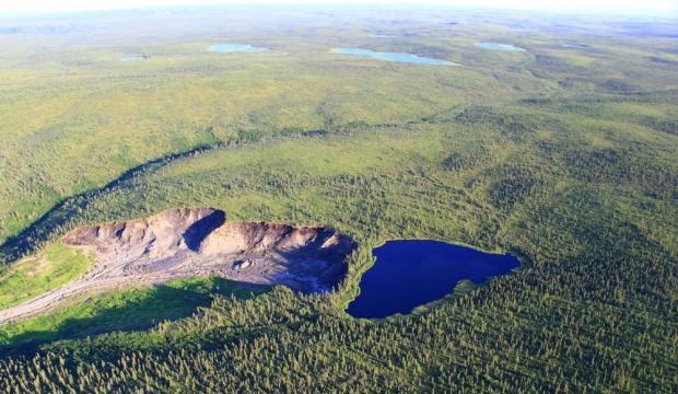
Fort McPherson mudslide, picture by Scott Zolkos, University of Alberta
.
Last week it was announced that the landslide retrogressed to the point that the barrier partially breached on 15th July . The event was reported in some detail in an article this week in Vice News, which notes that:
On July 15, between 8 and 9 pm, the slumping permafrost that held back the unnamed lake finally gave way. The ensuing cascade gushed roughly 30,000 cubic meters of water in a flow that could have filled a dozen Olympic swimming pools. Although remote camera’s captured the event, the extreme isolation of Fort McPherson, which sits roughly 1,800 miles due north of Vancouver, meant that news of the flood would not reach those studying the lake until weeks later.
Interestingly, the movement of the mudslide was captured in time-lapse footage by a web cam at the site. That footage is now on Youtube:
.
The mudflow is very interesting, not least the way that the mass accelerates as the water permeates through the debris. The partial breach has of course greatly reduced the hazard. However, the main point here is not this comparatively small if dramatic breach event near to Fort McPherson, but the way that warming temperatures is driving increasing amounts of thawing in these glacial deposits, triggering rising numbers of permafrost landslides like this one. As the Vice News article wisely observes:
Many other slumps throughout the region continue to alter the landscape and are clouding and clogging waterways with loads of sediment that scientists have found to have strong negative effects on aquatic ecology. According to Pisaric, these changes have provoked deep anxiety among the Gwich’ins of Fort McPherson, worries he said are shared among many communities across Canada’s north.
Scott Zolkos has some amazing images of these landslides on his blog.
12 December 2015
Two interesting landslide videos from Congjiang, China and Manali, India
A rockfall in Manali in India
In India a huge and very dramatic rockfall near to Manali was caught from two different perspectives. This is a Youtube video from one side:
.
With accompanying text that says:
Landslide in Mandi: A massive landslide occurred at the Chandigarh-Manali national highway 21 in Mandi. No casualty has been reported so far.
.
With accompanying text that says:
Live and Exclusive : landslide near Aut tunnel kullu, Himachal Pradesh (India)
I do think that this is a very interesting pair of videos in many ways. The main collapse event, as captured in the film, is fascinating. This is a still from the video as the initial collapse develops:-
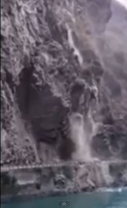
Rockfall at Manali,via Youtube
.
And this is a few seconds later:
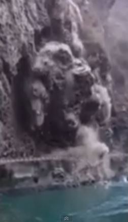
Rockfall at Manali
.
The rockfall appears to have developed in the lower block, nearer the camera, first, followed by the larger slice, further from the camera, thereafter. But interestingly the large initial block appears to have failed in one go, before fragmenting, but with the collapse being preceded by many small rockfalls. This is consistent with an event that is dominated by late stage fracture growth to promote the development of a detachment surface along which the failure occurred. Once again, road user have been protected by the small pre-collapse rockfalls, which were sufficient to cause road users to evacuate the area, and of course to film with their cameras.
.
Congjiang, China landslide video
Meanwhile, another really interesting video has appeared on Youtube courtesy of CCTV, the Chinese broadcaster. The text that has been posted with it says the following:
Surveillance camera on a street in Congjiang county in Gansu Province recorded the moment two buildings were destroyed by a landslide on Tuesday morning. After several people on the busy street noticed the landslide, they waved their hands and shouted to the drivers to make the them stop.
The wisdom of the driver who stops and in effect blocks the road just before the landslide is notable!
.
 Dave Petley is the Vice-Chancellor of the University of Hull in the United Kingdom. His blog provides commentary and analysis of landslide events occurring worldwide, including the landslides themselves, latest research, and conferences and meetings.
Recent Comments