
10 December 2015
Landslides triggered by Storm Desmond in the UK last weekend
Landslides triggered by Storm Desmond in the UK last weekend
Last weekend the UK suffered an extreme rainfall event as the fourth named storm of the winter, Storm Desmond, spun by. This event set a new 24 hour rainfall record for the UK – 341 mm at Honister Pass – and a 48 hour rainfall record too – 405 mm at Thirlmere. The UK has exceptionally long instrumental records for rainfall, so this was an extreme event by any account. Unsurprisingly, the level of damage is very high, with severe flood damage across quite a large area. In some places the floods have yet to recede, and further heavy rainfall is affecting this area as well.
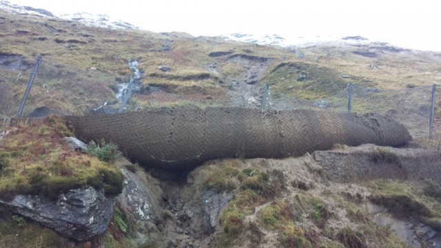
Early indications are that this event has triggered substantial numbers of landslides. The BGS Landslides twitter account ( @BGSLandslides ) has been retweeting various images of the landslides as they occur. These landslide include another slide on the A83 at Rest and Be Thankful. This is an old favourite, having suffered numerous debris flows in recent years. The main channel had a flexible barrier installed a couple of years ago, which seems to have done a fine job of catching the landslide:
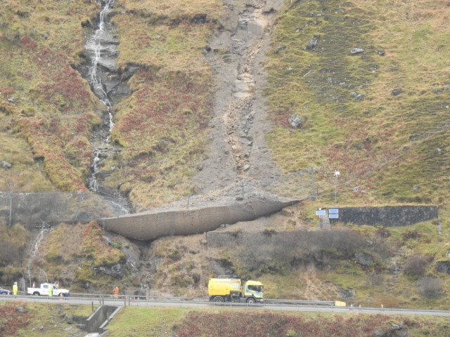
Landslide on the A83 at Rest and Be Thankful, courtesy of BEAR NW Trunk Roads
.
Landslide on the A83 at Rest and Be Thankful, courtesy of BEAR NW Trunk Roads
.
Most of the damage occurred in Cumbria though. This is a selection of the landslides that occurred there. One of the more damaging landslides appears to have struck a farm at Raisgill Hall:
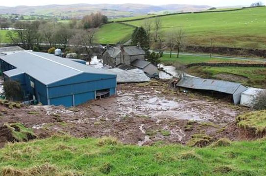
Raisgill Hall landslide triggered by Storm Desmond, courtesy of @JRfromStrickley
.
This small landslide blocked the Cumbrian Coast railway line:
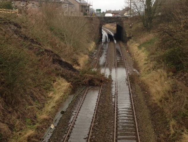
Cumbrian Coast line landslide triggered by Storm Desmond, image courtesy of Network Rail
.
This image shows two channelised debris flows near to Grasmere:
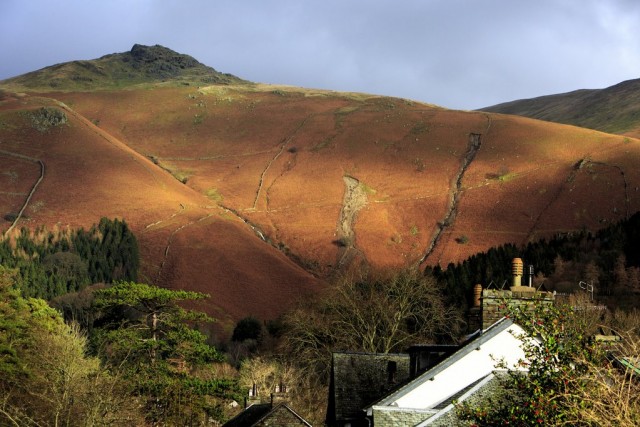
Channelised debris flows above Grasmere triggered by Storm Desmond, courtesy of @cumbrialivetv
.
Whilst this channelised debris flow occurred at Swarth Beck:
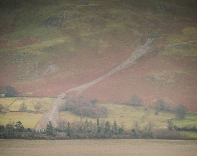
Swarth Beck landslide triggered by Storm Desmond, courtesy of @mark_lj
.
There are undoubtedly many more landslides too. Does anyone have any more?
3 December 2015
A cut slope failure on the Eskoriatza to Vitoria motorway in Spain
A cut slope failure on the Eskoriatza to Vitoria motorway in Spain
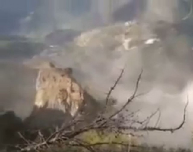
An interesting landslide occurred on a heavily modified slope on the Eskoriatza – Vitoria motorway in Spain on 27th November 2015. The main failure event was captured on video, and is now on Youtube:
.
I am impressed with the boldness of the highway authority in allowing one side of the road to remain open whilst this failure occurred.
Very helpfully, Fats Grasas has tweeted a sequence of images from a range of sources of the history of the slope. This appears to be a Google Street View image from 2009:-
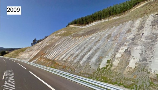
Eskoriatza – Vitoria motorway slope via Fats Grasas
.
Whilst this is a Google Earth image, also from 2009. The slope clearly has expensive treatment, but I am unsure as to what this is exactly.
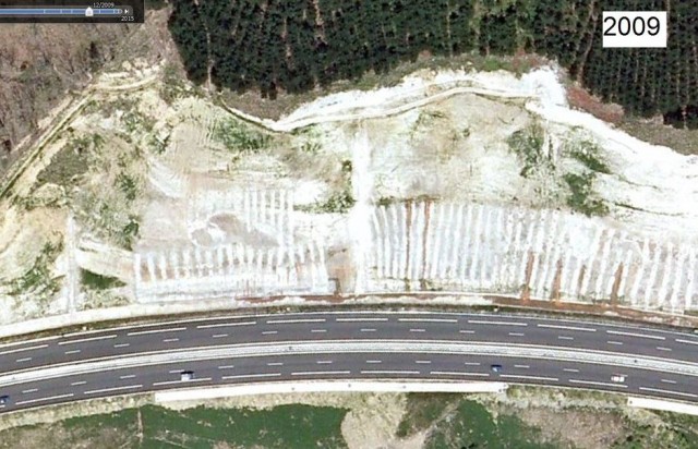
Eskoriatza – Vitoria motorway slope via Google Earth and Fats Grasas
.
Then this Google Street View image is from earlier this year:-
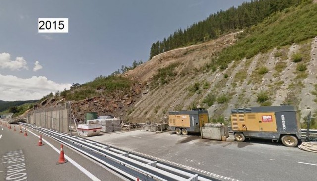
Eskoriatza – Vitoria motorway slope via Google Street View and Fats Grasas
.
The slope has clearly undergone a major failure, part of which has spilled onto the road. A Google Earth image, also from earlier this year, shows this failure in more detail:
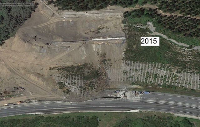
Eskoriatza – Vitoria motorway slope via Google Earth and Fats Grasas
.
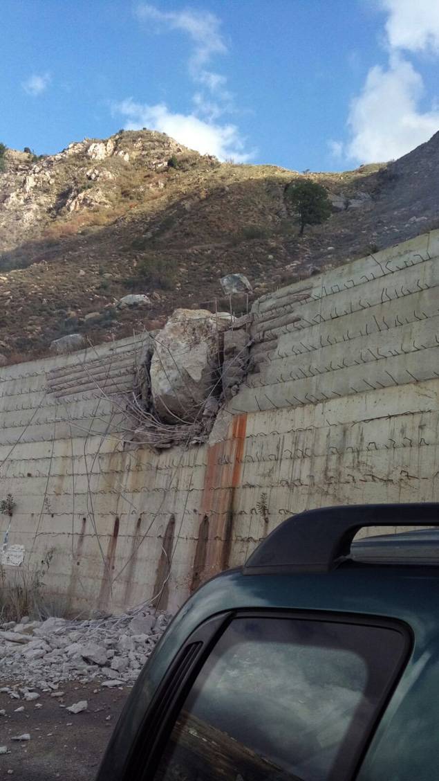
It appears that this failed slope was being repaired, with substantial reinforcement and fill. These slope strengthening works appear to have failed to generate the landslide last week.
2 December 2015
Shouf Mountains, Lebanon – a fascinating new landslide video
Landslide in the Shouf Mountains, Lebanon
This video was posted on Youtube yesterday showing a large rock topple event in the Shouf Mountains (sometimes spelt Chouf Mountains) of Lebanon:
.
The accompanying text provides little information:
Major landslide in Lebanon Shouf mountains. Luckily everyone was evacuated after first rockfalls. Keep an eye at the 1:02 mark and forward.
However, there is a news report on YaLibnan that provides some more information (and includes the video):
Horrified Residents of the town of Kfarnabrakh in the Chouf region evacuated their homes Monday after a landslide hit the outskirts of the town . “Very dangerous landslides have occurred in the outskirts of the Chouf town of Kfarnabrakh above the towns of Wadi al-Sitt and al-Fowara,” National News Agency reported. The landslide took place on Monday afternoon.
There are some images that show the aftermath. This one for example, from L’Orient Le Jour, shows some of the debris at the foot of the slope. The retaining wall has performed well!
Shouf Mountains landslide from L’Orient Le Jour
It is a pretty amazing example of a very large, complex rock topple. This image, from the video, shows the block rotating forward in the main collapse event:
Landslide in the Shouf Mountains of Lebanon
.
Acknowledgement
Thanks to the Canadian Geotechnical Journal (@CanGeotechJ) via Twitter. The original video was posted by Chadi El Mohtar (@ProfElMohtar).
27 November 2015
Who was to blame for the Hpakant jade mine landslide?
The Hpakant jade mine landslide in Burma
Media reports suggest that the rescue and recovery operations in the aftermath of the Hpakant jade mine landslide have now ceased, with 114 bodies recovered. The number of unrecovered victims is unclear, but is likely to to be in the order of a further 90 or so. Reporting on the incident remains somewhat mixed – for example many sources suggest that the landslide was 200 feet (about 60 m) high, whereas the images clearly show that it was very much larger than this, such as this one (via Reuters):
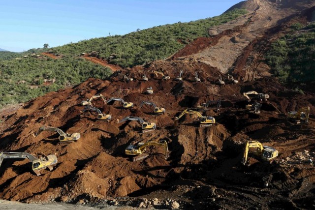
Rescue operations at the site of the Hpakant jade mine landslide (via Reuters)
Meanwhile, a war of words has broken out regarding who was to blame for the Hpakant jade mine landslide. A key statement has come from the Nobel laureate and political leader Aung San Suu Kyi (often known as Daw Suu), who reportedly stated:
“As far as we understand, it was the fifth similar incident this year. This sort of accident is common just because there is no rule of law. It also reflects lack of due consideration for the safety of people’s life and property.”
On the other hand, the Director general of the Department of Mines, U Win Htein, appears to disagree. The Myanmar Times reports:
“U Win Htein, director general of the Department of Mines under the Ministry of Mines, said there is no need to upgrade safety rules as companies involved were not breaking the law. He added that mining firms comply with all the rules and regulations, reporting monthly to the ministry on safety procedures and the impact of their activities.”
I cannot comment on the legal situation in Burma, so have no idea as to whether the mines at Hpakant were operating within the law. However, it must be a moral responsibility of any mining company to ensure that its waste tips are stable and safe. This is entirely achievable, and indeed is the norm in most of the world. Of course the legal framework should ensure that this is the case, but even without a set of laws the norm must be to ensure that the mines are safe. Attempts to blame the victims, which seems often to be the case when this sort of event occurs on the basis that they should not have been living there, are not reasonable in my view. The Myanmar Times reports:
“U Win Htein said while the ministry is providing aid, it cannot do much more, as victims of the landslide were in the area illegally. The ministry sets out specific areas for mining companies to dump their waste – people should not enter these areas to look for jade,” he said. “But some people from remote areas had built huts to stay there. The soil collapsed due to rain. It’s a tragic case and I am very unhappy that people were killed.”
The proximity of dwellings to the mining operations in the Hpakant area is disturbing. This is a Google Earth image of a small part of the Hpakant area:
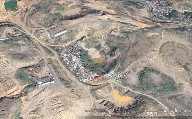
Google Earth image of the Hpakant area
.
26 November 2015
A debris flow of ice, water and sand?
A debris flow of ice, water and sand?
Just when you think you have seen it all, this pops up on Youtube:-
.
This event was apparently associated with the very heavy rainfall across the Middle East at the end of October and first half of December, as described by NASA. This debris flow appears to have been the result of a very heavy hailstorm, but I know no more. A still from the video,suggests that there is a large concentration of hailstones in it:

A debris flow of ice, water and sand via Youtube
.
I have never heard of such a debris flow, but am no expert on processes in deserts. I don’t even know if it is for real, though it does not look fake on first inspection. Does anyone know more?
Hat tip to Phil Ashworth on Twitter for coming across this one.
24 November 2015
The Burma jade mine landslide disaster
The Burma jade mine landslide disaster
News from within Burma about the jade mine landslide disaster is hard to find, so inevitably I have to rely on external reports. The Chinese news agency Xinhua reports that to date 113 bodies have been recovered, and there is a lack of clarity about how many more people may have died. The landslide struck an informal settlement, so little information is available. However, the Myanmar Times suggests that it is likely to be in the order of 200 people,
The best image I have seen of the landslide is this one, from Eleven Media Group / AP:
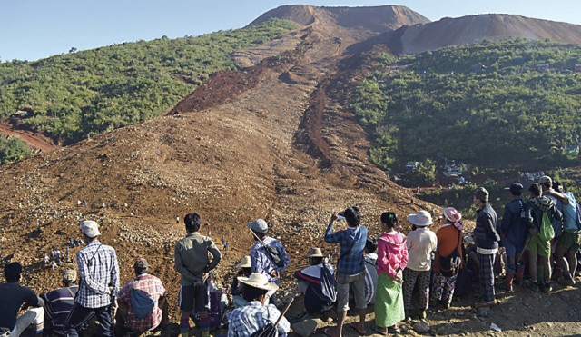
The Burma jade mine landslide, courtesy of Eleven Media Group, (Eleven Media Group via AP)
.
The image appears to show a classic mining flowslide, originating from a spoil heap. Note the figures in the lower part of the landslide in a small track, which give an idea of the scale of the Burma jade mine landslide. The slide itself has in interesting structure, with very strong levee structures on both sides. Note also a small number of houses on the right side of the landslide – this may give an indication as to the location of the settlement before the landslide. There can be essentially no prospect of survivors.
Landslides of this type should be entirely avoidable – the potential for the failure of spoil tips has been known for half a decade, and in countries with good mine management the occurrence is now very low. That there are these repeated mining landslides in the jade mine area of Kachin State indicates poor mining practices.
Youtube has some mobile phone footage of the attempts to recover the victims:-
.
Whilst mining practices by illegal miners are undoubtedly very dangerous, this landslide is unlikely to have been triggered by such small scale activity. The other spoil tips on the photograph above have similar geometries to the one that failed. These need urgent attention.
23 November 2015
A rather splendid rock and ice avalanche video from New Zealand
Mount Cook rock and ice avalanche from a video by Ryan Taylor
A rather splendid rock and ice avalanche video from New Zealand
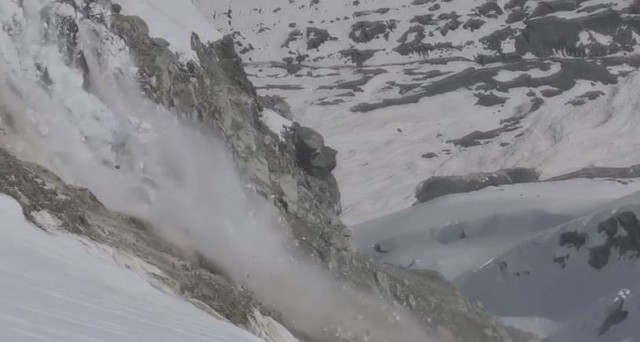
Ryan Taylor was on a ski mountaineering trip in Mount Cook National Park when he captured a quite splendid rock and ice avalanche that originated from the Hochstetter Ice Fall below Mt Cook itself:-
In the commentary that he posted on Youtube he wrote the following:
Glacier collapsing in Mt Cook National Park, New Zealand caught by photographer Ryan Taylor during a ski mountaineering trip. I also captured a series of ice the size of several buildings falling off the Hochstetter Ice Fall below Mt Cook (highest peak in NZ). Similar events are naturally occurring several times a day (at 13 seconds in the video you can see a similar, smaller collapse in the background of the video) but it is evident climate change is causing glaciers to recede at an unprecedented rate. New Zealand’s 1st ski area was once located on the Ball glacier below Mt Cook which is now covered in rock debris. I assume with increasing average temperatures we are seeing more melting and consequently an increasing ratio of rainfall to snowfall in the accumulation areas of glaciers. It is important to raise awareness around climate change at this time with the international conference on climate change in Paris coming up. For those who don’t care about the glaciers disappearing it has potential to effect economies through loss of tourism and means less water available for irrigation.
The transition of this collapse event into a rock and ice avalanche is very interesting, as is the motion of the mass on the low angles slopes below. Of course this is quite a low friction system, with ice rich debris moving across a frozen surface, so mobility of the landslide mass is comparatively high.
22 November 2015
Vasquez Canyon: a new landslide in Santa Clarita, California
Vasquez Canyon landslide
A significant landslide has developed in the last few days in Vasquez Canyon, in Santa Clarita in California. The landslide, which appears to be progressive and has no obvious recent trigger, has caused extensive buckling of the road, which has been closed over a three kilometre stretch. This image, from the Santa Clarita Valley Signal, provides quite a good general view of the situation beyond the road:
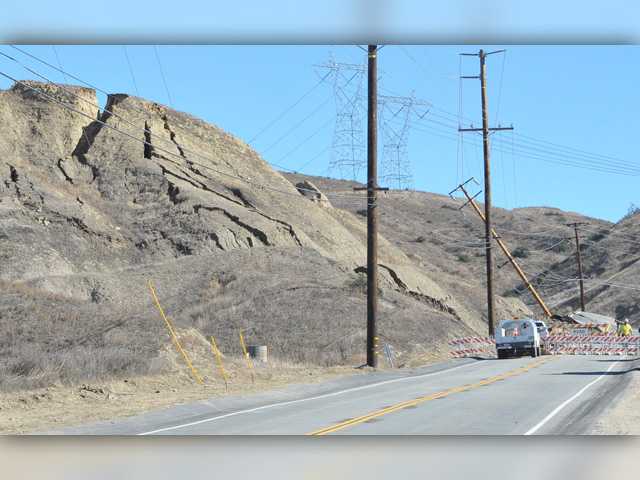
The landslide, from the Santa Clarita Valley Signal
.
The landslide has caused impressive damage to the highway:
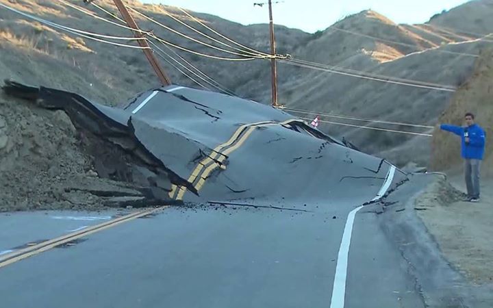
Vasquez Canyon road from KTLA5
.
.
interestingly, the media are suggesting that this buckling has occurred because the road is moving upwards. Whilst this might sound a little odd, this excellent drone footage suggests that this might the case:
.
This is a still from the drone footage of the landslides, showing the damage to the highway:
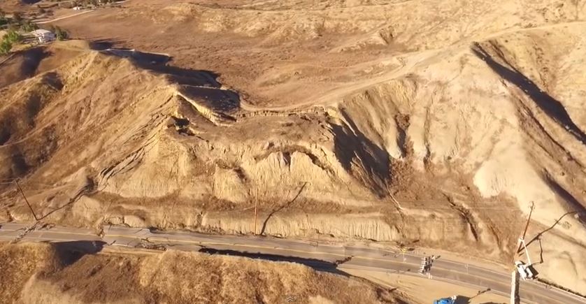
Vasquez Canyon Road via Youtube
.
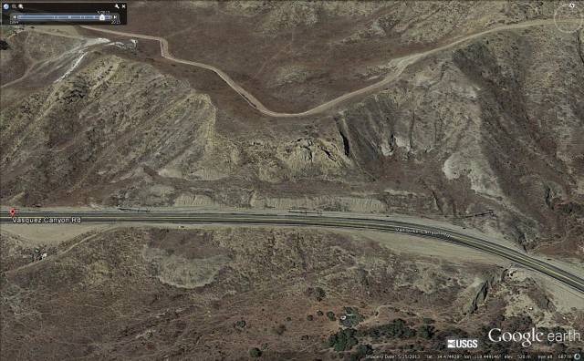
This is Google Earth imagery of this section of the road, dated April 2015 – i.e. seven months ago:
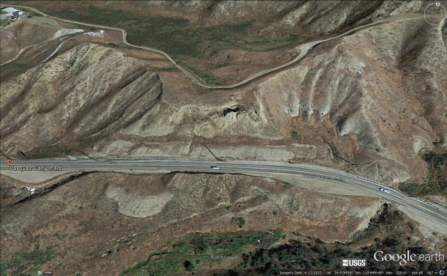
Vasquez Canyon Road via Google Earth
.
There are clearly some signs of instability in this image, and note the other landslides in the image. The section of road that has failed is in a box cut, so it would appear that unloading of the slope may be a key factor in the landslide. And interestingly, this imagery from two years ago (May 2013) suggests significant movement at that time as well:
Vasquez Canyon road in 2013 from Google Earth
.
And finally, this is Google Street View imagery of the road, taken in 2011:

Vasquez Canyon road via Google street view
.
The extensive deformation in the road was clear even then – indeed the road shows longitudinal cracks along this entire section. Thus, although this landslide looks very sudden, it has been developing over a prolonged period.
19 November 2015
Lefkada: dramatic landslides from the earthquake on 17th November
Lefkada landslides
On Tuesday western Greece was affected by a shallow (depth = 14 km) M=6.5 earthquake centred close to Nidri. This is the USGS location of the earthquake on Google Earth, with the intensity contours:
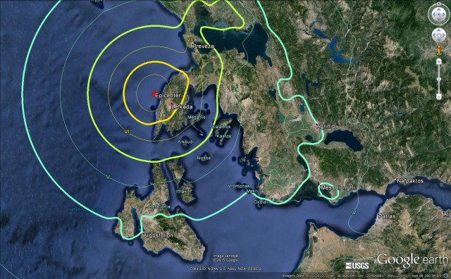
USGS epicentre and intensity contours for the earthquake near Lefkada, plotted on Google Earth
.
The nearest piece of land is the island of Lefkada. On the west coast of the island is a famously beautiful beach at Egremni:
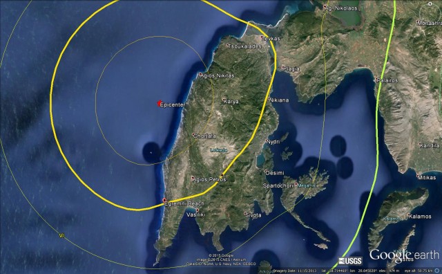
a The location of Egremni beach, plotted on Google Earth
.
The Pappas Post has a very nice article about landslides triggered by the earthquake that have affected the beach. This is the beach prior to the earthquake, from Flickr:
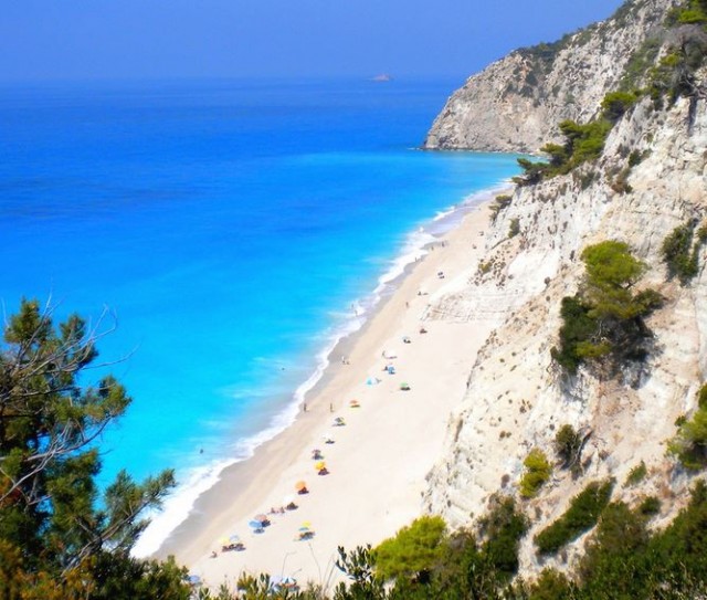
Egremni beach before the earthquake via Flickr
.
The landslides that affected Egremni Beach were captured on a video by a fisherman who was located on a boat just off the coast:-
.
The aftermath is a series of large landslides that have left very large volumes of debris on the beach. This oblique aerial shot, from The Pappas Post, shows the largest of the landslides (note the smaller ones at the top of the image too):
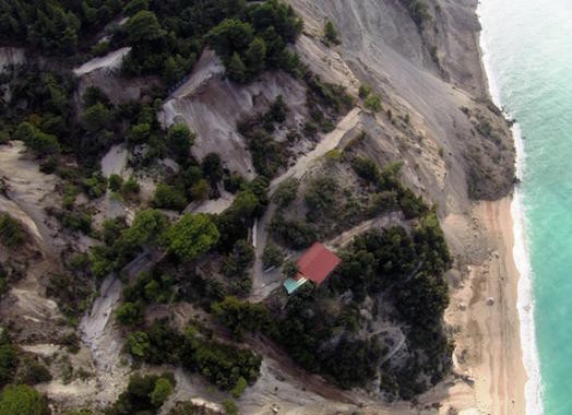
The major landslide on Egremni Beach on Lefkada, via The Pappas Post
.
And this image, also from The Papas Post, shows the landslide from a more traditional near-vertical perspective:
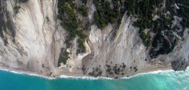
The major landslide on Egremni Beach on Lefkada, via The Pappas Post
.
If this earthquake had occurred on a summer day then there would have been a large number of fatalities on the beach at Lefkada, so in a sense this was very lucky escape. However, it is also likely that the debris from these landslides will take a long time to clear, such that Egremni Beach has been changed in perpetuity.
According to the Washington Post, there were two fatalities in the earthquake. One of these, a 69 year old woman, was killed by a rockfall that struck her house.
17 November 2015
High resolution imagery of the Bento Rodrigues dam failures
High resolution imagery of the Bento Rodrigues dam failures
Thanks to the many people who have been providing comments on my posts about the Bento Rodrigues dam failures (see posts here, here, here and here). We have been frustrated by the lack of high resolution images, either satellite or aerial photograph, of the failure site. However, overnight Caner Zanbak tracked down a site with SPOT 6/7 imagery of the site, provided by Airbus Defence and Space. For the first time we can see properly what happened. This is an overview of the Bento Rodrigues dam failures:-
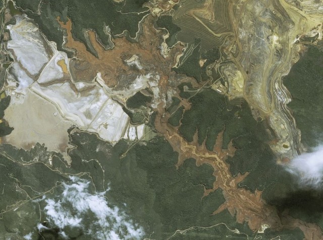
SPOT 6/7 image of the Bento Rodrigues dam failures via Airbus Defence and Space
.
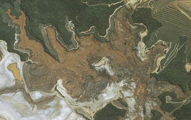
For comparison this is the Google Earth image of the same location, taken in 2013:
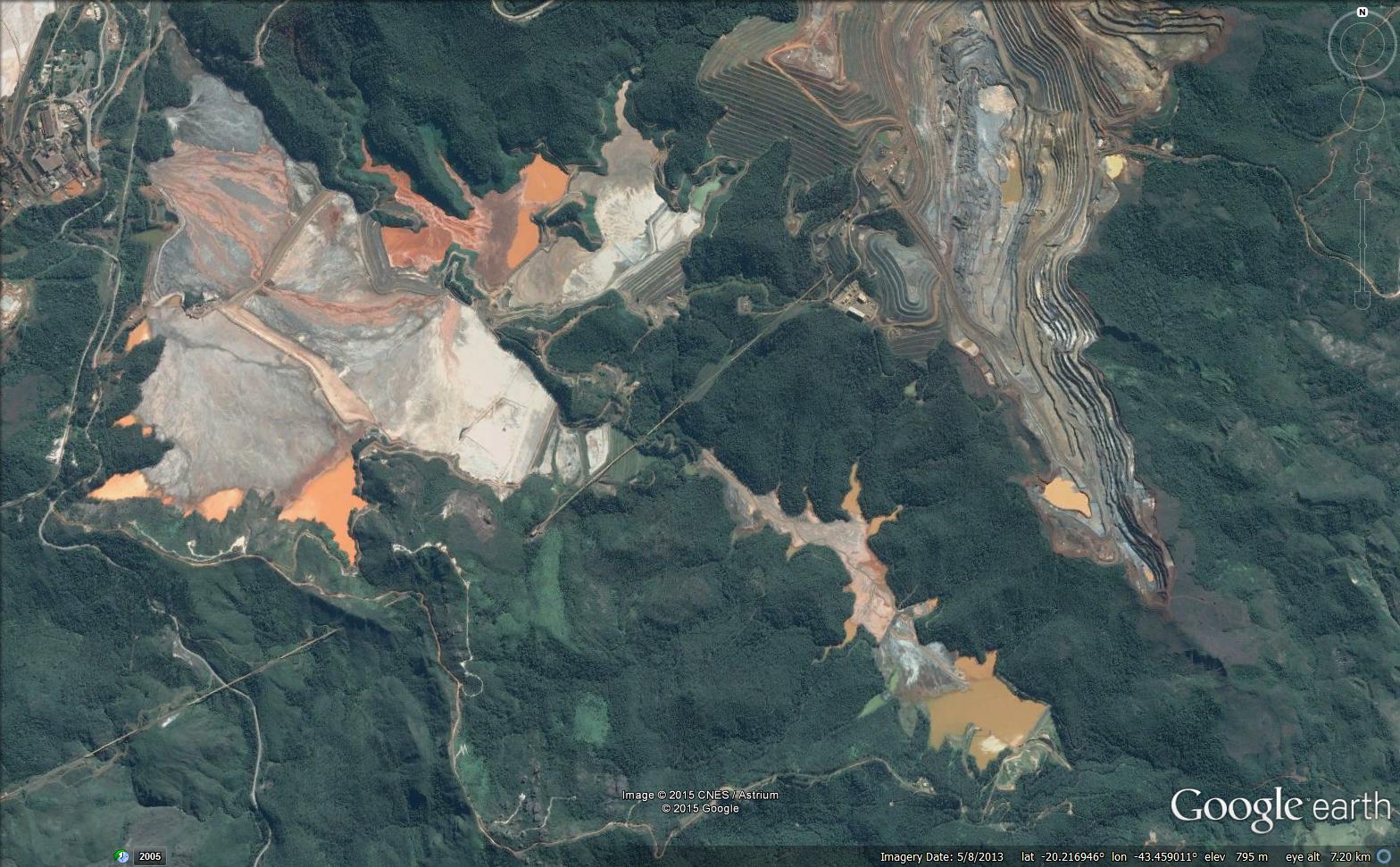
Google Earth image of the Bento Rodrigues dam failures
.
This is a zoomed in image of the failed tailings pond and the Fundao Dam site:
SPOT 6/7 imagery of the Bento Rodrigues dam failures via Airbus Defence and Space
.
This is Google Earth imagery of the same site from 2013. I have annotated the image:
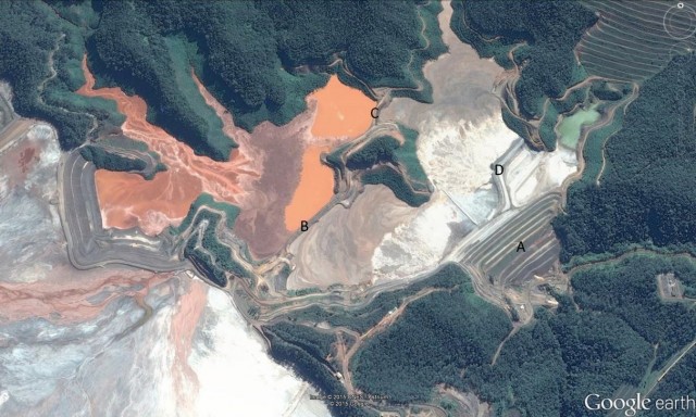
Google Earth imagery of the Bento Rodrigues dam failures from 2013
.
The Fundao Dam, which I have marked A, has filed completely. Indeed there is hardly a trace remaining of the original structure. But note also the near-total removal of the levees marked B, C and D on the image above. This begs the question as to the collapse sequence – did for example, collapse of levee B trigger the failure of Fundao Dam? My sense is that it remains most likely that the Fundao Dam itself failed first, and that the loss of support from the other levees then triggered their subsequent collapse. I cannot see how a collapse of levee B would have triggered collapse of levee C for example, unless this caused a loss of support. However, others will know more about such things than me, and I would welcome comments and observations.
Downstream the debris reached and then overwhelmed the Santarem dam. This SPOT 6/7 image shows the site:

SPOT 6/7 image of the Bento Rodrigues dam failures via Airbus Defence and Space
.
This is the 2013 Google Earth image in comparison, with the dam annotated with letter E:
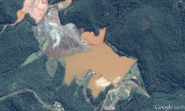
Google Earth image of the site of the Bento Rodrigues dam from 2013 failures
.
Whilst the Santarem dam was undoubtedly overwhelmed and severely damaged, much of the structure appears to be intact – indeed the original spillway is still visible. This structure is now retaining a large volume of tailings, so ensuring that it remains intact must be a priority.
At the moment this event looks like a catastrophic, near-complete failure of the Fundao Dam, followed by failures of the other levees in the tailings ponds. A key question remains as to what caused and triggered this catastrophic failure,
 Dave Petley is the Vice-Chancellor of the University of Hull in the United Kingdom. His blog provides commentary and analysis of landslide events occurring worldwide, including the landslides themselves, latest research, and conferences and meetings.
Recent Comments