
22 January 2016
The Punta Tre Amici rockslide in Italy
The Punta Tre Amici rockslide
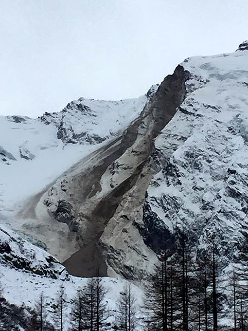
On 16th December 2015 the Punta Tre Amici rockslide occurred on a rock slope on the flanks of Monte Rosa in northern Italy. The rockslide, which had a volume of about 200,000 cubic metres, was detected on a network of three seismometers, indicating that the main collapse occurred at about 8:25 pm local time. There is a very detailed description (in Italian), and lots of images, of this landslide on the Nimbus Web Glaciologia website. Google Translate does a fine job on the text, which is rendered quite clear. This is a post-event image of the Punta Tre Amici rockslide:-

Punta Tre Amici rockslide via Nimbus Web Glaciologia
.
The rockslide left the cliff in a quasi-stable state, and it has subsequently been subjected to repeated subsequent rockfall events (and avalanches, as the image above shows). This means that the rockfall scar and deposit has continued to evolve with time. Nimbus Web Glaciogia has this image of the landslide, taken on 8th January:
Punta Tre Amigi rockslide on 8th January 2015 via Nimbus Web Glaciologia and F. M. Cornaggia
.
The Nimbus Web Glaciologia article indicates that this is an area that has been subject to considerable slope instability in recent years. It also indicates that there might be an interesting temperature-related aspect to this rockslide. They provide this graph of temperatures in the days leading up to the rockfall event:
Temperatures in the period leading up to the Punta Tre Amici rockslide via Nimbus Web Glaciologia and SMI. Note that the temperature record is from Milan Linate airport
.
The Nimbus Web Glaciologia (translated by Google and then corrected by me) notes that:
The late fall 2015 in the Alps has been marked by persistent subtropical anticyclones, therefore exceptional mildness and lack of snowfall. In particular, a period of extreme warmth was observed in the days leading up to 10th November 10, with extremes never previously recorded at that time of year, with temperatures of about 7 ° C at about 3000 m in the free atmosphere above the Northern Italy and Monte Rosa, therefore with [ground temperature] well above 0° C and the likely presence of liquid water still in circulation to the portion of the detachment of the landslide (at about 3400 m). In late November, there was a temporary cold period (-15 ° C at 3000 m)…followed by milder weeks in December, but without reaching the extremes of the previous month, while there was a continued extraordinary lack of snow, limited to a few centimeters on the shady slopes.
It is well established that global warming is driving an increase in high elevation temperatures, and a dramatic increase in permafrost degradation and thus an increase in rockfalls, in mountain chains. This may well be yet another example. We will see many more in the years ahead.
21 January 2016
Landslides in Chile Part 3: the Meson Alto rock avalanche
The Meson Alto rock avalanche
A few kilometres upstream from the Las Cortaderas rock avalanche lies one of the truly great landslides, the Meson Alto rock avalanche. This landslide is so large – 4.5 cubic kilometres, which is more than 10 billion tonnes of rock – that it can only really be shown properly on a satellite image:
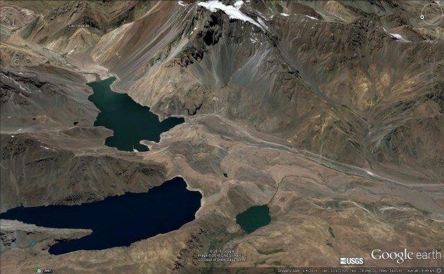
Meson Alto rock avalanche via Google Earth
.
I have annotated the Google Earth image below to show the main features of the landslide. Note that the boundaries are approximate, particularly on the downstream part of the deposit, where there may be a combination of rock avalanche deposits and redeposited landslide material from the outburst flood:
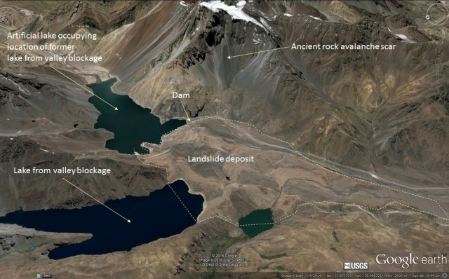
The Meson Alto Rock Avalanche via Google Earth, annotated to show the main features
.
The landslide scar is very clear, as is the huge landslide deposit. Note the way that it has spread downstream. The rock avalanche is described in detail in a great paper, available online, by Deckart et al. (2014). They point out that this is a rock avalanche that has been deposited on top of glacial moraine. The landslide is believed to have occurred about 4,500 years ago. This is the landslide from downstream:

Meson Alto rock avalanche from downstream
.
Note the fluvial (river) terraces between the camera and the deposit in the background. These may be a combination of the lake deposits from the Las Cortederas landslide and the flood terraces from the breach of the Meson Alto rock avalanche. This is the artificial dam that has been built to create a lake at the site of a previous natural lake impounded by the landslide. At some point the natural lake must have drained through a substantial breach event:
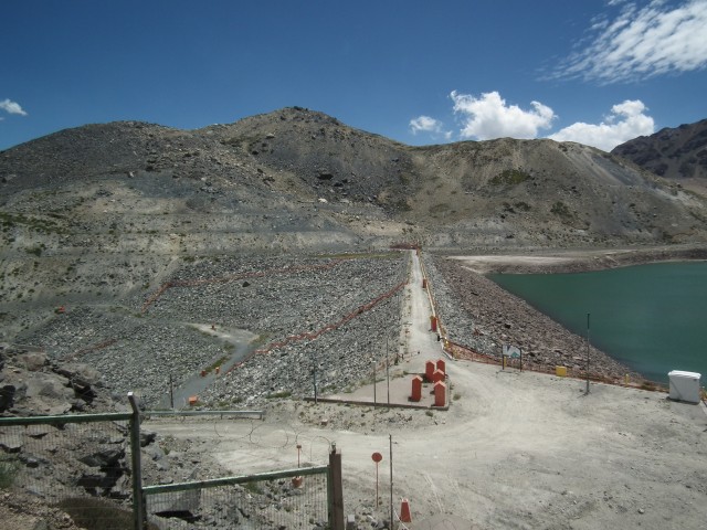
The artificial rock dam at the site of the Meson Alto rock avalanche
.
The landslide deposit is the huge pile of debris in the background, Note how large the dam is in this image – compare that with the Google Earth image above. This gives an idea of the scale of this landslide. Capturing the scale of the landslide is extremely difficult. This is an attempt at a composite image to take in all of the landslide features, taken from the banks of the lake:
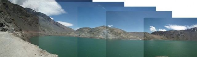
Alton Meso rock avalanche
.
Part of the landslide scar is on the left of the image, and the landslide extends across the image to the rock slope on the right side. The dam blocks the space between the mound of debris and the rock wall on the left side of the image.
Reference
Deckart, K., Pinochet, K., Sepulveda, S., Pinto, L., and Moreiras, S. 2014. New insights on the origin of the Meson Alto deposit, Yeso Valley, central Chile: A composite deposit of glacial and landslide processes? Andean Geology 41 (1): 248-258/
20 January 2016
Landslides in Chile Part 2: Las Cortaderas
Landslides in Chile Part 2: Las Cortaderas Landslide
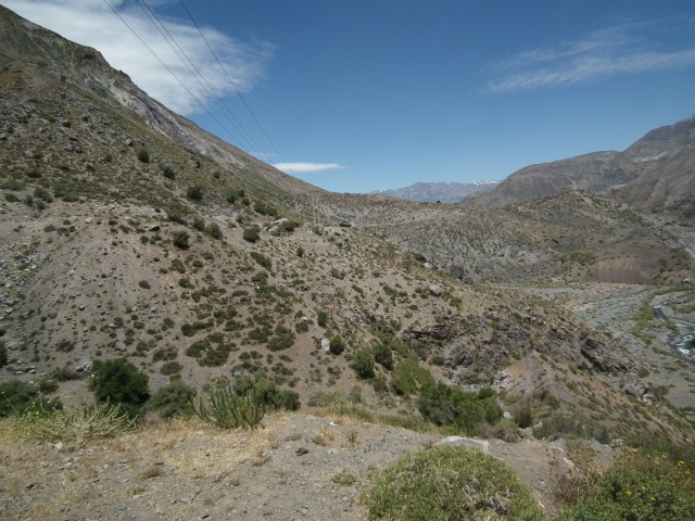
Located not far from Santiago, in the upper reaches of the Maipo River catchment, is a very large mass movement, known as the Las Cortaderas Landslide. This is a fascinating landslide, not least because there are two distinct phases. The main landslide is vast – an ancient rock avalanche that entered the valley at some point in the past (of which more below). The frontal portion of this landslide deposit then failed again in the 1958 Las Melosas earthquake, blocking the Yeso River. This makes the later landslide sound like a small event – it is certainly not. Sepulveda et al. (2008) estimated that it had a volume of 15 to 20 million cubic metres, which is a large landslide by any standard. The river was blocked for a few years before breaching naturally. This is a view of the landslide from upstream:
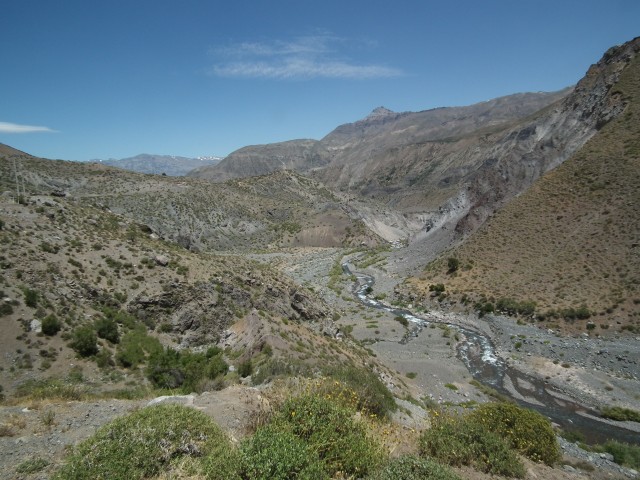
Las Cortaderas Landslide from upstream
.
To illustrate the features of the lower part of the landslide, I have annotated the photograph below:
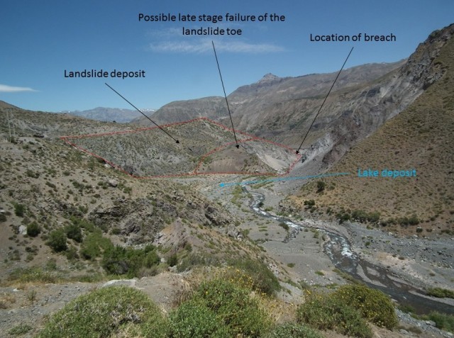
Annotated image of the Las Cortaderas Landslide
.
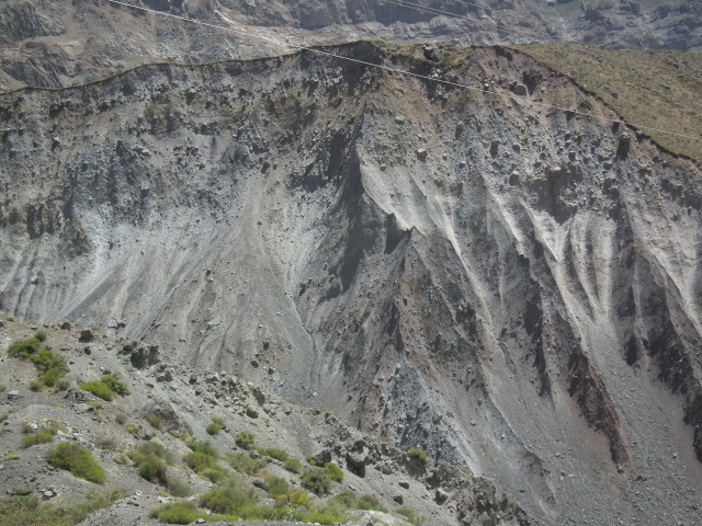
This image shows the landslide scar with the deposit on the right hand side (the scar is just to the left of the power cables):
Las Cortaderas Landslide
.
But, as mentioned above, the 1958 La Cortaderas landslide is a comparatively small failure of the deposit of a much larger landslide body. This is the Google Earth image of the site – I have annotated the 1958 landslide and the larger rock avalanche deposit from which it originated:-
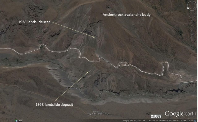
Las Cortaderas Landslide via Google Earth
.
Taking a wider view though, the scale of the ancient rock avalanche becomes clear:
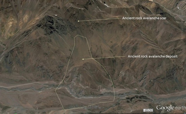
Las Cortaderas Landslide
.
This is a truly huge landslide that would have blocked the river before breaching. The current river cuts through the landslide deposit, leaving a portion of the deposit on the other side of the valley. This is clearly exposed by the river. Note the chaotic landslide deposit, with the predominance of the largest boulders occurring in the upper portions:-
Las Cortaderas Landslide deposit
.
But if you think this is large, you should see what lies upstream – of which more tomorrow.
17 January 2016
Landslides in Chile Part 1: Arauco
Landslides in Chile Part 1: Arauco
I have spent the last week in Chile working with colleagues from the University of Chile and Leeds University, plus Melanie Froude, my post-doctoral researcher at UEA, on our Newton Fund / NERC project on earthquake-induced landslides. Over the next few days I’ll post some images of the landslides that we are studying. One of field areas is in Arauco, about two hours south of Concepcion, which was affected a M=8.8 earthquake on 27th February 2010. This earthquake caused extensive damage, most notably as a result of a tsunami that affected the coastal areas.
As part of our project we are building an inventory of landslides triggered by that earthquake. Our field trip was to look at these landslides and to collect some samples for the detailed testing that is being undertaken at Durham University. The samples are from this set of very interesting coastal landslides:
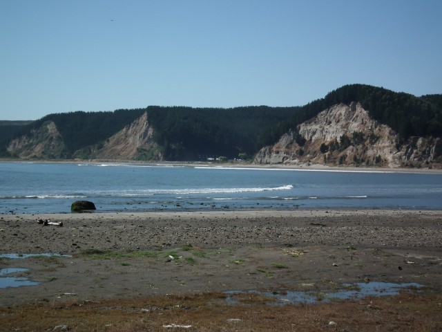
Coastal landslides near to Arauco
.
These are steep but shallow landslides that caused damage to the coastal highway. Our main study landslide is the one in the middle. Further around the headland there are some more interesting landslides. This one was initially triggered by the earthquake, but then has reactivated and enlarged, damaging the new road:
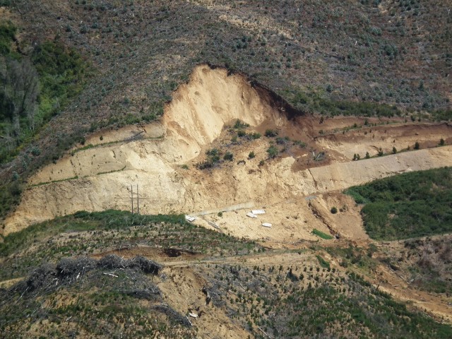
An inland landslide near to Arauco
.
On the same road there is a section that crosses a much older but very active landslide. This is a soil / earthflow type of slide:
Highway landslide near to Arauco
.
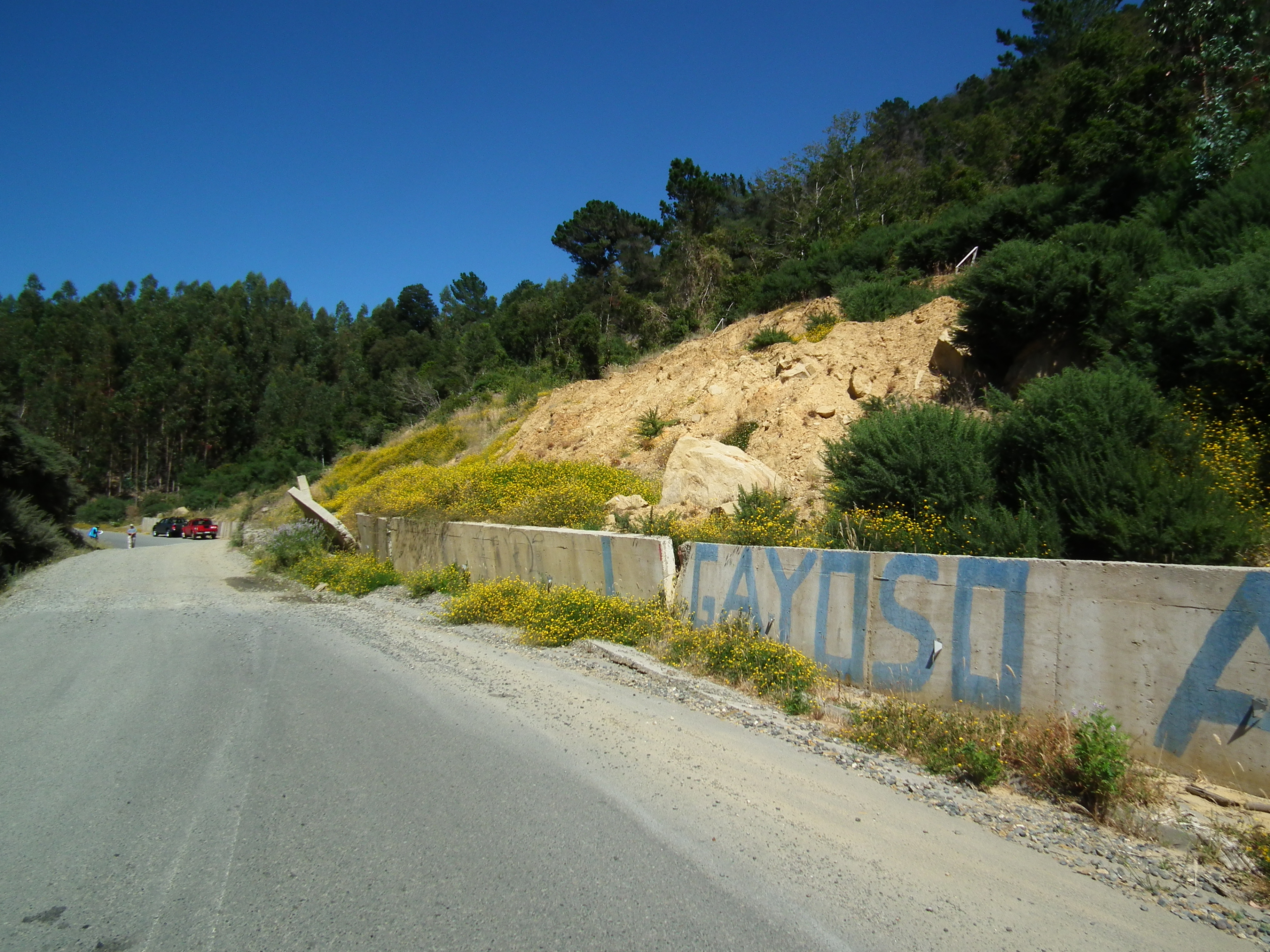
This landslide is having a very significant effect on the highway. Most notably, the lower portion has displaced and damaged the retaining wall:
.
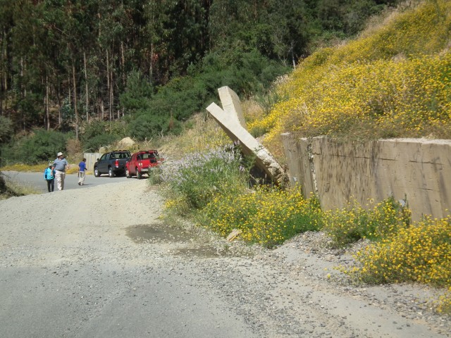
A retaining wall toppled by a landslide in Arauco
.
Dealing with multihazards is very challenging, The coastal communities in this area can be subject to earthquake shaking, tsunamis and landslides. Sometimes the advice that is given to avoid two hazards is mutually contradictory. This is a nice example, where the evacuation route for a tsunami takes the citizens right into the potential path of rockfalls. In the event of a large earthquake this slope is likely to be unstable, with aftershocks bringing material down. The affected population might have a terrible decision to make:
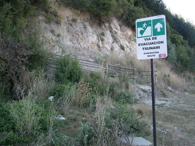
Tsunami evacuation route and rockfall site near to Arauco
15 January 2016
Wolhusen: an interesting river-blocking rockfall in Switzerland
Wolhusen rockfall
On Monday a large rockfall occurred on a cliff in the town of Wolhusen in Switzerland. The rockfall itself was large – estimates suggest around 500 cubic metres, with a reported maximum travel distance of 200 metres. Significantly though, the rockfall blocked and diverted the Kleine Emme river. Water flowed through a part of the town, causing extensive damage.
The best set of images that I have found is in this report in the Luzerner Zeitung (the report is in German of course). This aerial image gives the setting rather nicely, showing both the deposit and the diverted river flowing through a part of Wolhusen:
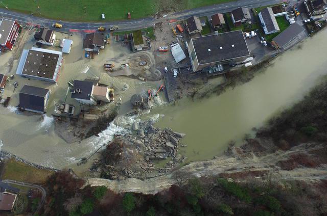
Drone footage of the Wolhusen rockfall, via Luzerner Zeitung
.
Whilst this image gives a good view of the rockfall itself:
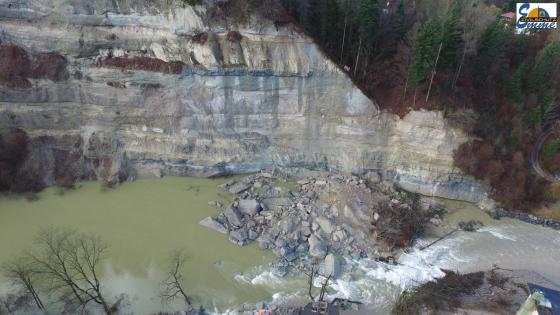
Wolhusen rockfall via Luzerner Zeitung
.
It does appear that the rockfall itself was unusually energetic. The Luzerner Zeitung report also includes this image of damage to one of the adjacent building, appearing to show impact marks from debris extending to a high level. It is fortunate that no-one was in the way of one of these pieces of rock. This can be explained by the timing of the rockfall, which was at night:
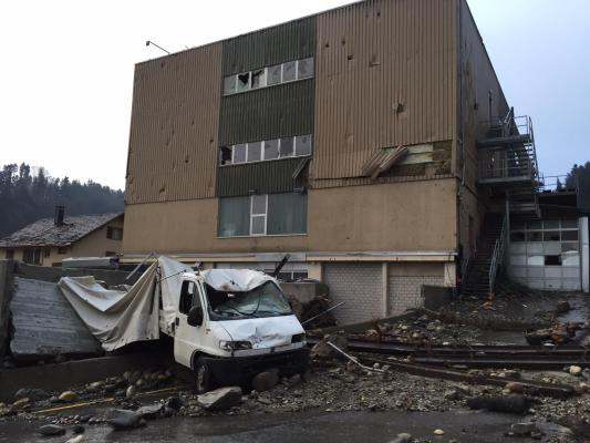
Rockfall impact marks on an adjacent building, via Luzerner Zeitung
.
The report suggests that the damage will cost over a million Swiss Francs (which is about US$1 million). Note from the first image that the landslide occurred on the outside of a gentle curve of the river, which would suggest that the key mechanism here might have been undercutting of the rock face. In the second image the unweathered surface shows the origin of the landslide – it appears that there is at least some recent fracturing here to allow the final detachment to occur. I am unclear as to whether there was a distinct triggering event.
12 January 2016
A major rockslide on US2 near Wenatchee
A major rockslide on US2 near Wenatchee
The Washington State (USA) Department of Transport twitter account (@wsdot) has images of a major rockslide that occurred in US2 west of Waterville near to Wenatchee. This is not a trivial event by any means:
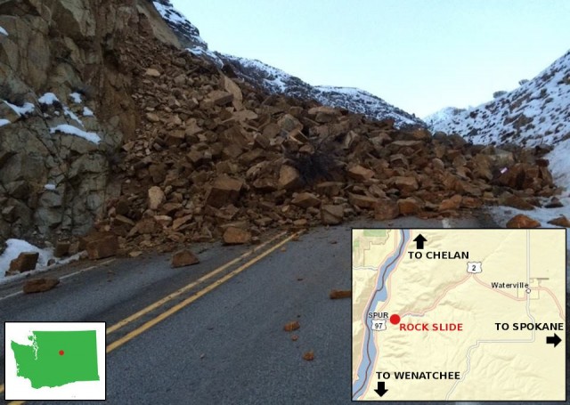
Landslide on US2 near to Wenatchee courtesy of Washington State DoT
.
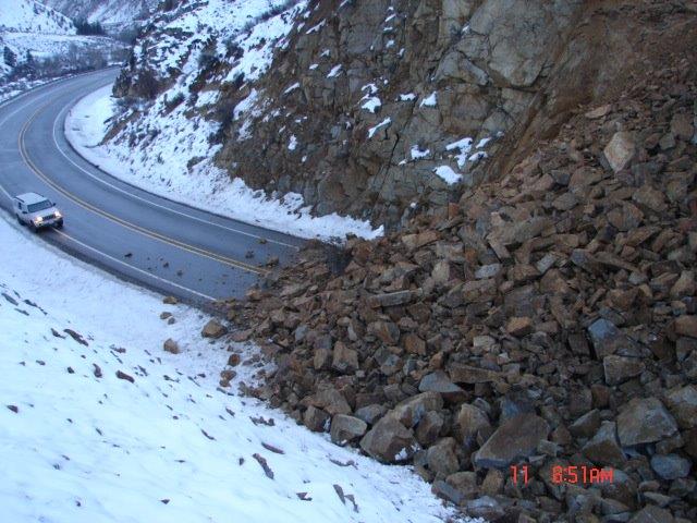
Landslide on US2 courtesy of Washington State DoT
.
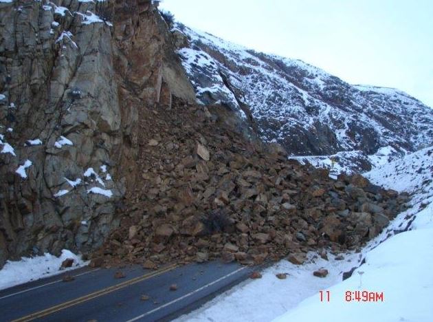
Landslide on US2 courtesy of Washington State DoT
.
Looking at the third image, this is a complex wedge type failure on existing joints. There appears to be weathering on the newly exposed surfaces. Looking at the rest of the rock mass, the joint pattern is very complex, so this is a difficult slope to manage and mitigate.
Moving some of the large boulders is going to be a major task.
11 January 2016
The weirdness of Mass Ejection Landslides in China
Mass Ejection Landslides
A paper (Tang et al. 2015) has recently been published in a Special Issue of the reputable journal Engineering Geology that considers mechanisms of a high energy, long run out landslide type that occurred in the 2008 Wenchuan Earthquake in China. These mass movements are termed Mass Ejection Landslides. In the paper these landslides, fully termed “mass ejection type of high-speed and long-run-out” (ME-HSLR) landslide are described as follows:
“This type of landslide is characterized by concealed development, sudden break-out, dramatic ejection of landslide material through the air, and devastating consequences … Therefore, in a general sense this type of ME-HSLR landslide can be also described as rock avalanches with the feature of becoming airborne”
Chinese authors have described six of these mass ejection landslides in the Wenchuan earthquake, although the vast majority of the papers are in Chinese. Now, there are two weird things about these landslides. First, as described in the literature these landslides were literally ejected from the ground to fly with a ballistic trajectory through the air before running out. And second, as far as I am aware these landslides have never been described anywhere else.
Now, if the paper by Tang et al. (2015) (there is a PDF of this paper online here) is correct, these landslides are truly miraculous. The “take-off” velocities for the mass ejection range from 25 m/sec for the enormous Daguangbao landslide to 75 m/sec for the Jingu landslide. Most are 70 m/sec or more. To put that into context, 70 m/sec is about 250 km/hr. That is seriously fast! And remember that this is not something that happens down the landslide track, or at the bottom of a near vertical slope, this is how the landslide leaves the source area. As Tang et al. (2015) put it:
“In this paper, the term “take-off speed” is exactly the speed when the landslide mass has moved a considerable distance and reaches the “ski jump”, and at this speed, the slope mass is torn out from the mother body.”
So the argument goes that these landslides area able to reach velocities of 250 km/h from a standing start as they depart the source area.
Tang et al. (2015) illustrate their paper with the Jingu landslide, which had a volume of about 2 million cubic metres. This landslide can be seen in the Google Earth imagery of the area, taken in 2010:
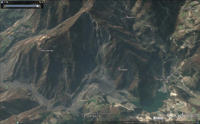
The Jingu landslide from Google Earth. This is reported to be one of the Mass Ejection Landslides
.
This is clearly a large and mobile landslide, but there is nothing in the image that I can see that suggests it had an initial airborne component. In their paper, Tang et al. (2015) describe it thus:
“During the earthquake, the slope mass of the upper throwing depletion zone was sheared and torn from the main body of the landslide, and the huge mass was launched from the location of the upper and lower boundary. After flying several hundred meters, the ejected mass seriously impacted the area across the river, and formed a huge area of debris splash.”
The justification for this interpretation, as far as I can understand it, is that the landslide deposit was thick on the far side of the river from the landslide (towards the foot of the slope in the image above) than closer to the source, and that after the landslide there was little evidence that the river had been blocked for long. This is said to infer that the landslide mass must have flown across the river to end as a pile on the far side.
I am afraid that I am somewhat doubtful of this. The behaviour seems too extreme, the velocities so high, and the mechanism so exotic that I think there must be a simpler explanation., It is true that landslides can reach very high velocities, but usually only after descending steep slopes, often with very low friction conditions being established. To me a much simpler explanation is that the landslide failed conventionally, descended the lower (steep) slope conventionally, achieving a high velocity. The mass then travelled across the valley with almost no deposition before striking the opposite valley wall and stopping. Thus, it left little material in the river.
This is a much simpler mechanism that seems to fit all of the known facts without requiring extraordinary processes that have not been described elsewhere, Thus, to be honest, I remain to be convinced that Mass Ejection landslides are a real phenomena.
I welcome the thoughts of others.
Reference
Tang, H-M., Liu, X, Hu, X-L. and Griffiths, D.V. 2015. Evaluation of landslide mechanisms characterized by high-speed mass ejection and long-run-out based on events following the Wenchuan earthquake, Engineering Geology, 194, 12-24. (available online here).
9 January 2016
The Farnley Haugh landslide in Northumberland, northern England
The Farnley Haugh landslide in Northumberland, northern England
In the spell of extremely heavy rainfall that has affected the UK in the last few weeks, railway slopes have inevitably suffered. Perhaps the most interesting landslide is at Farnley Haugh in Northumberland on the line that connects Newcastle to Carlisle – this is an essentially east – west link across the Pennine hills that connects between the two main north-south railway lines. The Farnley Haugh landslide has closed the section of line between Prudhoe and Hexham. The closure is indefinite, [with Northern Rail saying:
Customers are being advised that the line between Hexham and Prudhoe will be closed for several weeks to allow the area to be safely assessed and restored.
BGS Landslides retweeted an aerial image of the landslide:
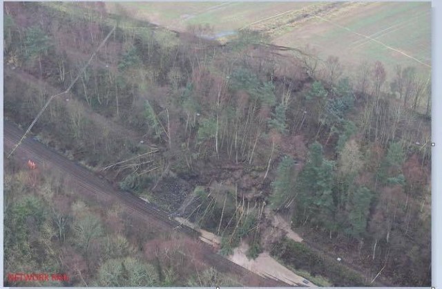
Farnley Haugh landslide via a BGS Landslides retweet
.
At present the portion of the landslide that has affected the line is a comparatively small more active section on the lower right side of the active slope, where the trees have fallen. The large amount of fine sediment on the track in this area is interesting – I wonder where the water that has transported this sediment has come from. But the landslide is larger than this, with major tension cracks extending into the field at the rear of the cutting. Note that there appears to be a ditch in the field close to this section. Northern Rail have released an image of this portion of the landslide complex:
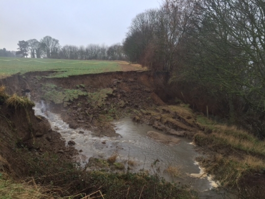
The Farnley Haugh landslide via Northern Rail
.
Once again there is a huge amount of water flowing into the landslide, right in the area of the tension scarps. The image does not really show the source of this water, but there is a good chance that this is a significant factor in the landslide.
As far as I can tell this is the section of embankment that has failed (from Google Earth):
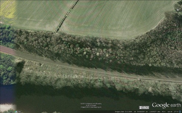
The Farnley Haugh landslide site, via Google Earth
.
But as this image dates from 2009 it provides little more information. One thing to note is that the ditch does seem to be associated with a channel on the cutting, and there appears to be a culvert under the track.
Stabilising this slope is a large task, though completely within the capabilities of the engineers at Network Rail, and their contractors.
6 January 2016
Landslides in Art Part 24 – Mary Buckland
Landslides in Art – in Mary Buckland
On 25th December 1839 a very large coastal landslide occurred at Bindon in Dorset, southern England. This was a large landslide – it is reported that the mass that moved was 150 m by 500 m, and up to 70 m thick (if we assume an average thickness of 50 m this would give a volume of about 3.75 million cubic metres). The Bindon Landslide caused something of a sensation in Victorian Britain, which of course was increasingly interested in the ways in which the natural world operated. There was particular interest in a feature that became known as Goat Island – a large displaced block – and a large deep tension crack, which became known as The Great Chasm, at its landward side. The landslide inspired a range of artistic work, including a piece of music – the Landslide Quadrille.
The Bindon Landslide is significant in a number of ways. Perhaps the most important is that it was described in detail by two local clergymen, William Buckland and William Conybeare, and a local suveryor, William Dawson. This is commonly thought to be the first detailed scientific description of a landslide. The three Williams produced a detailed published account of the Bindon Landslide, with a set of quite beautiful illustrations by Mary Buckland, the wife of William Buckland. This monograph has been put online in full by the Lyme Regis museum. The illustrations by Mary Buckland are quite beautiful, and stand the test of time as art in their own right. I am featuring just two here, but I recommend that you take a look at the full set. First, this is an engraving of the Bindon landslide from the east, looking west. Goat Island is the large mass on the centre left of the landslide complex, with The Great Chasm dividing it from the back-tilted blocks below the cliffs:
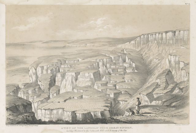
The Bindon Landslide by Mary Buckland
.
And second, this is a detailed engraving of The Great Chasm:
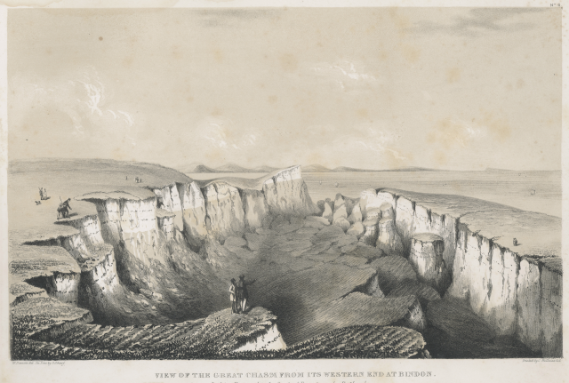
The Great Chasm, part of the Bindon Landslide, by Mary Buckland
.
Note the detail that Mary Buckland captured in this image, including the stratigraphy and the geometry of the displaced blocks. The figures are indicative of the level of interest that the landslide generated in Victorian society.
For those that are interested, there is a reassessment of the mechanisms of the Bindon landslide in a paper by Gallois (2010), which is available online. The paper concludes that:
“Recent geological surveys have confirmed that the description by the Bucklands, Conybeare and Dawson is an outstanding example of observation and analysis, and that their interpretation of the mechanism, although incomplete, was superior to that of any subsequent account.”
The previous edition of this Landslides in Art series is available here.
Reference
Gallois, R.W.. 2010 The failure mechanism of the 1839 Bindon Landslide, Devon, UK : almost right first time. Geoscience in South-West England : Proceedings of the Ussher Society, 12. 188-197.
5 January 2016
Abergeldie Castle: extreme riverbank erosion threatens a 16th Century castle in Scotland
Abergeldie Castle
The ongoing sequence of extreme rainfall events in western and northern Britain has brought a sequence of floods and landslides over the last month, causing high levels of damage to Lancashire, Yorkshire, Cumbria and various parts of Scotland. The most recent event – heavy rainfall in northern and western Scotland yesterday – triggered high river levels on the, amongst others, the River Dee in Aberdeenshire. Located near to the royal Balmorral Estate, Abergeldie Castle is a magnificent four storey tower house built in about 1550 on the banks of the Dee, as shown in this aerial image from Flickr:
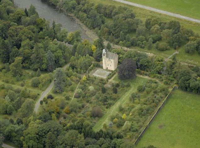
Abergeldie Castle via Flickr
.
As the image shows, the castle is located close to but not immediately beside the banks of the Dee. Unfortunately, the very high river flows associated with the recent rainfall has triggered extensive erosion of the banks of this section of the Dee, and the castle is now at extreme risk of being lost. The Guardian has provided a description of the situation:
Images of the rising flood show Abergeldie Castle, a Grade A-listed building, just a few feet from the water’s edge, with parts of the estate reportedly being swept away. Baron Abergeldie, John Gordon, 76, and his wife sought refuge with their neighbour Gordon Fraser after deciding it was too dangerous to remain in their ancestral home in Aberdeenshire. He is now understood to have moved to another property on the estate. “He left the castle when the river was at its height. It swept the embankment away,” Fraser told the Scottish Daily Record. “It moved a 60ft lump of ground and took a lot of big mature trees as well.”
The Press and Journal has this image of the state of the castle at present:
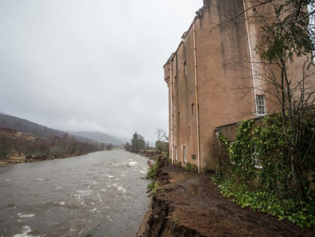
Abergeldie Castle via the Press and Journal
.
Sadly, Aberdeenshire has a yellow warning for rain today, and a further one for Thursday, when another band of heavy rainfall will sweep across Britain:
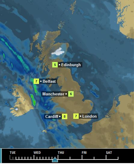 Weather forecast for Abergeldie Castle, via the BBC
 Dave Petley is the Vice-Chancellor of the University of Hull in the United Kingdom. His blog provides commentary and analysis of landslide events occurring worldwide, including the landslides themselves, latest research, and conferences and meetings.
Recent Comments