15 December 2015
Tillamook in Oregon: crowd sourcing a landslide repair
Posted by Dave Petley
Tillamook landslide in Oregon
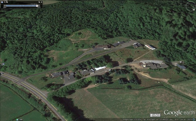
Near to the town of Tillamook in Oregon a small group of householders has suffered the nightmare of discovering that their properties are built on or close to an active landslide. The slide appears to have activated during the recent exceptionally wet weather, to devastating effect. This is I believe the collection of houses, as shown on Google Earth:
.
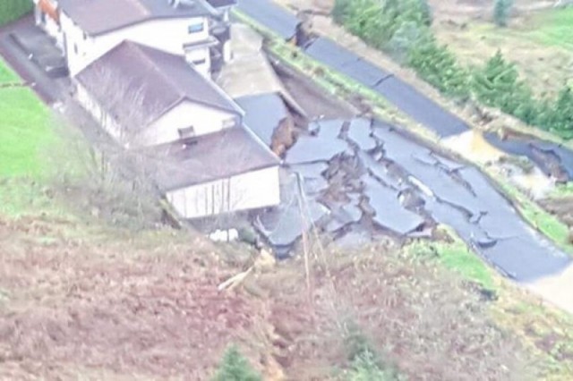
The active landslide is not apparent on this image, though the steep back scarp and hummocky deposit hints at previous movements, perhaps. The recent movement is large – this image from KOIN6, shows the surface displacement on a section of the landslide:

Tillamook landslide via KOIN6
.
As usual to really understand this landslide we need an overview image. So far I haven’t been able to track down a good one, this is the best I can find:

Tillamook landslide via Morgan Kottre
.
The amount of displacement on this landslide is impressive. The various images seem to indicate that it may be retrogressing. It appears to be dominantly translational – there is perhaps a surprising lack of rotation. The images show that there is a lot of water present (note the large puddles in the image above).
As is so often the case, the owners of the properties are in a very difficult position. residential insurance does not usually cover landslide damage, and as this is private land the local, state and national government are very unlikely to assist. However, this is not a community that is willing to stand back, so they have started a crowd-sourcing campaign to raise funds to support their repair. The organiser of the campaign, Morgan Kottre, notes the following:
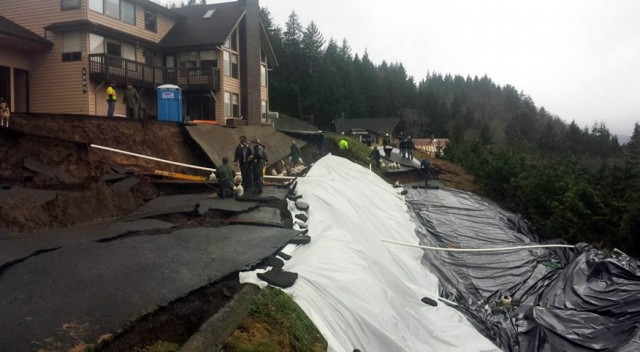
The pictures don’t do the damage justice. You can just make out one of us standing by the crevass, just to the right of the middle in the picture. I don’t have the words to sufficiently describe it. It is massive. It goes beyond the roads – cutting across the entire hill. Drop offs of up to twenty feet, easily. The entire main road shoved at least fifteen feet downhill. Crevasses and craters and canyons galore. Everything wants to continue to move and fall. We have had geologists, contractors, and engineers come survey the damage. Everyone was blown away. To see it in person is the only way to truly grasp it. The barn down the way has been irreparably damaged, and the families still fear for their homes. The three of us on the upper road are currently isolated, as this was our one way down the hill.
…
Any money donated will be used directly to save what can be saved and repair what can be repaired. This is going to be a costly, lengthy process. Honestly, we believe it will cost much more than the goal of $100,000. Engineers and geologists will need to be hired to figure out the safest way to calm Mother Nature. They will bring in big expensive drills and take core samples. This process alone will cost at least $5k. They will then design a specific plan on how we go about saving the hill. The ground will have to be stabilized. Vast expanses of hillside will need extensive work with heavy machinery. Hopefully, we can do this before we have another slide. Any springs of water – of which there are many – will need to be trained and corralled into going down the hill safely. There is the chance that we will have to reshape large pieces of property. Eventually, this will need to be dug out. Potentially, with the help of professionals, we can rebuild our road.
At the time of writing the campaign has raised a little over $13,000. I wish them luck – this is an absolute nightmare for any homeowner.


 Dave Petley is the Vice-Chancellor of the University of Hull in the United Kingdom. His blog provides commentary and analysis of landslide events occurring worldwide, including the landslides themselves, latest research, and conferences and meetings.
Can I know the coordinates of the location? (for research purposes)
Thanks
[45.428, -123.847 D.]
It appears the slide involved only Burton Hill Road and the house immediately above (south of) it. Perhaps the excavation below the road to provide building space on the south side of Hillside Dr. (the lower road) was a factor.