7 February 2012
An official report on the Tumbi Quarry landslide
Posted by Dave Petley
The National Disaster Council of Papua New Guinea has posted online a report into the Tumbi Quarry landslide (see previous posts here, here, and here). Presumably this is the “official investigation” that was promised. They should be credited with making this available online, and the document has some useful information on, and images of, the landslide. It is also helpful to get the official view on the landslide event, and there is a management plan for the victims and survivors of the accident.
However, there are aspects of the report that are perhaps interesting, as follows:
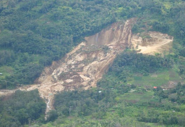
1. The report only very briefly mentions the quarry. The report states that “naturally high geological weaknesses assisted by abnormally high rain fall combined to cause subsidence to the immediate north west of the quarry triggering a landslide of composite debris.” The image on the front cover clearly shows a part of the quarry, with some of the benches truncated by the lateral margin of the landslide:
The report is ambiguous as to whether this means that the landslide was associated with the quarry. It maybe that the quarry access / haul road also crossed the area now destroyed by the landslide (as per the Esso Highlands plan), and yet this is also not discussed. Clearly at least a part of the quarry was lost in the landslide, so a proper discussion of whether the quarry played a role in activating these weaknesses seems essential to me.
Note also that these naturally-occurring geological weaknesses are not described or discussed (I assume that this means a set of joints?), and the mechanism of “subsidence” is also quite strange.
2. The landslide trigger is definitively described as being rainfall, on the basis that there was no recorded seismicity. However, although “continuous heavy rainfall” is described, there is no data to support this, and no eye-witness reports. The next sentence talks about “abnormally high rainfall”, but I can find no other reference to this event. I wonder what evidence there is for this abnormal rainfall event, given the high rainfall that this area is likely to receive anyway.
3. There are odd aspects of the landslide mechanism as described in the report. First, the report notes that pools and seepage on the shear face indicate that the “ground water rose significantly above its historical levels”. I do not understand this logic. Seepage and pools are likely to occur in the aftermath of almost any deep landslide of this type, and I do not see why they indicate that the groundwater levels were abnormally high, or indeed that groundwater even played a substantial role. Second, the report notes that the initial assessment team “saw clear evidence of liquefaction of the rock formation”. This is most surprising. Limestone is not a material that undergoes liquefaction – I have never heard of such a mechanism in any hard (as defined from an engineering behaviour perspective) rock – and so I just cannot understand this purported process. Unfortunately, it is not discussed further.
So overall, whilst the description of the site is really helpful, though it would be good to see a more detailed consideration of the ways in which the quarry might have been a factor in activating these geological weaknesses. In designing a quarry it is normal practice to ensure that such natural weaknesses are not exposed to the point that they can permit slope failure to occur.
To my mind this report should not be considered to be the definitive analysis of this landslide. Much more detailed analysis is needed, and lessons need to be learnt in terms of other slopes in Papua New Guinea.


 Dave Petley is the Vice-Chancellor of the University of Hull in the United Kingdom. His blog provides commentary and analysis of landslide events occurring worldwide, including the landslides themselves, latest research, and conferences and meetings.
You’re being very generous in your assessment of this report! Seems many questions remain.
Interesting comments. But limestone is not a hard rock. And I think yellow limestones are softer than the typical European limestones. Of course limestone is vulnerable to water damage, and to being impacted by wet and somewhat acidic ground (not uncommon in PNG) but the report’s use of the word “liquefaction” was a bit dubious.
[In engineering terms, which is the sense that the term is being used here, limestone is a hard rock. The quarry is for aggregate – you don’t make aggregate from soft rocks. Dave.]
Ok cheers for that report. It says it makes a “low grade” aggregate. Limestone is still not a hard rock.
One other thing. What do you mean by “as per Esso Highlands plan”?
[see earlier posts – the report here: http://pnglng.com/media/pdfs/committment/PGHUEHSPZZZ410003_Tumbi_Quarry__QA_1__RAP_Rev_0_Website_48956.pdf
[…] people have asked what I mean by a proper landslide investigation with respect to the report on the Tumbi Quarry landslide. To illustrate, one might compare these two […]
[…] still vaguely mention an estimated number of 25 people, and possibly as many as 60. Even the unimpressive National Disaster Centre report said only: “At this stage, there is no exact figure of the […]
[…] even though it is clear from the images that a section of it was removed by the landslide. In an earlier post I questioned both the evidence for rainfall / high groundwater as the trigger and the lack of […]