17 April 2023
The Arroyo Seco landslide in Monterey County, California
Posted by Dave Petley
The Arroyo Seco landslide in Monterey County, California
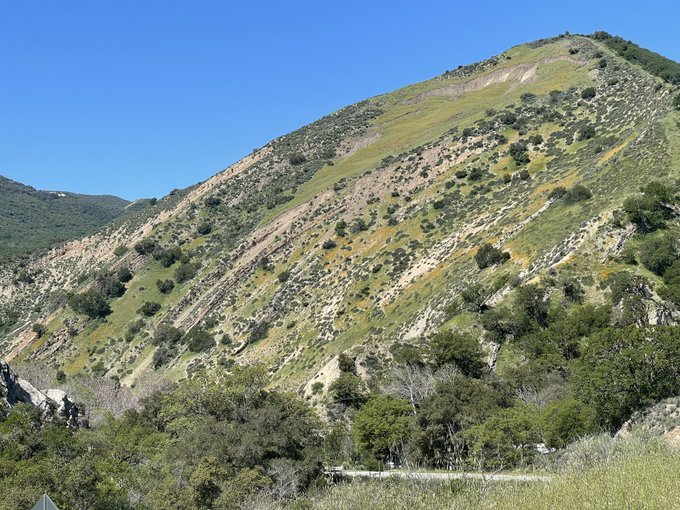
Over the last week, concerns have been raised about a landslide that has developed in Arroyo Seco in Monterey County in California, USA. The best image I have found of the setting of the landslide was tweeted by Karl Cooke, a journalist with KION 5/46:-

An overview of the Arroyo Seco landslide in California. Image tweeted by Karl Cooke.
.
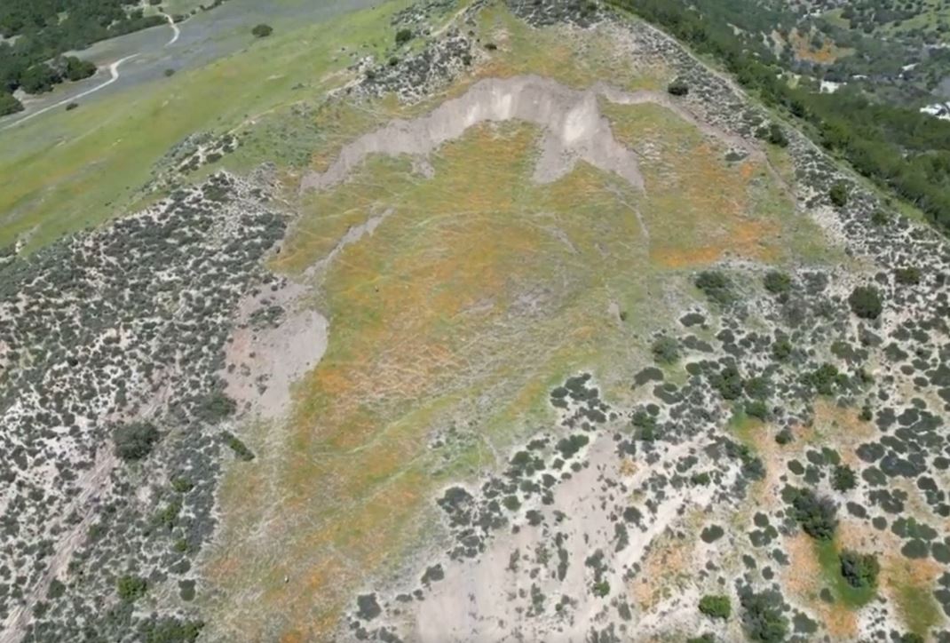
There is a more detailed image of the landslide itself in a drone video of the landslide that was posted to Facebook by Felix Cortez, who is a reporter for KSBW Action News 8:-

A view of the Arroyo Seco landslide in California. Still from a drone video posted to Facebook by Felix Cortez.
.
The local authorities have rightly closed the road at the foot of the slope. The landslide is being monitored by the USGS.
The trigger for the landslide is not clear, but California has suffered a series of major rainstorms through the winter and the spring. In January, the high level of the river necessitated a helicopter rescue for a couple living in the area.
This landslide might well be a substantial headache for the inhabitants of the area and the people trying to keep them safe. Movement of the slope is likely to be hard to predict. One scenario is that the slope fully fails, creating a debris pile that can be removed, albeit at substantial cost. A more difficult scenario is that the slope does not fully fail, leaving a hazard on the slope that will place the road at risk. Experience from elsewhere suggests that decision-making in this situation is a challenge.
A tweet from KION News Channel 46 provides a really nice 3D view of the slope. It appears that the failure is occurring on geological strata that dip in parallel to the slope?
ARROYO SECO FACES POSSIBLE LANDSLIDE
Read more: https://t.co/Ou057UOKNz pic.twitter.com/4WP4gNofLO— KION News Channel 46 (@KIONnews) April 13, 2023


 Dave Petley is the Vice-Chancellor of the University of Hull in the United Kingdom. His blog provides commentary and analysis of landslide events occurring worldwide, including the landslides themselves, latest research, and conferences and meetings.
Hi Dave,
As always, I enjoy your posts. The site is actually in central California, in the Salinian Block. I’m fairly sure the coordinates are 36.258426°, -121.432294°.
The geology there is Miocene Monterey Shale overlying crystalline basement rocks. Faulting has severely dissected the area. A good geologic map is the Preliminary Geologic Map of the Point Sur 30′ x 60′ Quadrangle (easy to download by an Internet search of the filename).
The Arroyo Seco River takes a sharp bend to the north in the Millers Ranch area. Notice the bedrock exposures (white surfaces above the roadway) immediately west of the failure area.
Warmest Regards,
Ernie
KSBW8 has an article explaining the original fear was the landslide would be large enough to block the river.
https://www.ksbw.com/article/geologists-monitor-assess-arroyo-seco-landslide/43595501
The KSBW Monterey article locates the slide as ” near the intersection of Arroyo Seco Road and Carmel Valley Road ” [ 36.2574711, -121.4234357 ]. This appears to be close to the camera location of the Karl Cooke image and consistent with Ernie’s location of the slide. The Google Earth image shows erosion above Arroyo Seco River (translation from Spanish creek, dry), consistent with wasting foot of the landslide.
Here is a 10 minute, 3D pan movie of aerial imagery and slope map from bare earth lidar of the site of the Arroyo Seco 2023 landslide: https://youtu.be/10DKdD3ZtjQ
NWS climate plots, showing cumulative water year precipitation at
Monterey: https://www.weather.gov/images/mtr/cliplot/KMRY2022b10plot.png
and
Salinas: https://www.weather.gov/images/mtr/cliplot/KSNS2022b10plot.png
Both stations are about 31 miles, 50 kilometers northwest of the landslide.
Source: https://www.weather.gov/mtr/cliplot