
20 May 2022
The Mount Popa debris avalanche
Posted by Dave Petley
The Mount Popa debris avalanche
Yesterday, in response to the coverage of the 42nd anniversary of the 1980 Mount St Helens flank collapse and eruption, Wang Yu (@Wangyu1979) tweeted a Google Earth image of the Mount Popa volcano in Myanmar. This is my version of the image that he tweeted:-
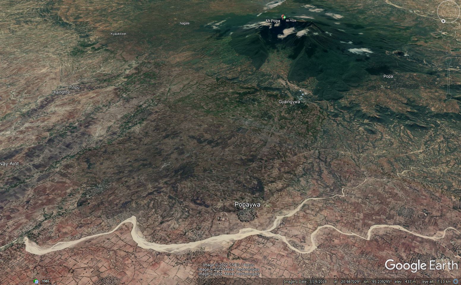
Google Earth image of the aftermath of the flank collapse at Mount Popa in Myanmar.
.
The image beautifully illustrates that Mount Popa has also undergone a flank collapse event (a flank collapse is an extremely large-scale landslide on the flanks of a volcano). The huge gap in the side of the volcano is the scar of the landslide.
The sequence of events at Mount Popa is described in a paper published in 2018 in the The Journal of Volcanology and Geothermal Research (Belousov et al. 2018). They demonstrated that Mount Popa underwent a catastrophic flank collapse about 8,000 years ago. The resultant debris avalanche, which had a volume of about 1.3 cubic kilometres, travelled about 11 km from the former summit of Mount Popa. The landslide debris is 5.5 km wide and on average 50 m thick.
By any standard this is a vast landslide.
On the Google Earth image below I have marked the approximate boundaries of the debris avalanche deposit – it is reasonably easy to see in the landscape at this scale:-
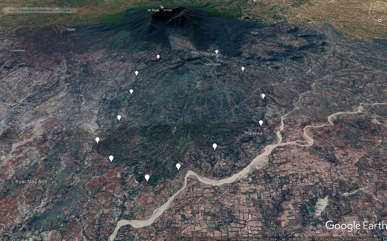
Google Earth image of the aftermath of the flank collapse at Mount Popa in Myanmar, marked with the approximate boundaries of the debris avalanche.
.
Belousov et al. (2018) suggest that prior to the collapse, magma moved up through the volcano, whereupon the flank collapsed. Unlike Mount St Helens, there is no evidence of a directed blast. The landslide occurred in two stages, with an initial failure of about 1 cubic kilometre, followed by a smaller (0.3 cubic kilometre) secondary failure shortly after. The subsequent volcanic eruption generated pyroclastic flows that are now draped over the landslide deposit.
There is no geological evidence of any volcanic eruption since this date, although some historical accounts suggest that some sort of small event occurred in the year 442 BCE. What this represents is uncertain in the absence of any geological evidence.
There is no doubt that this site deserves more detailed investigation, but the scale of the geologically recent flank collapse at Mount Popa is truly epic. These huge volcanic landslides are some of the most impressive landslides on Earth.
.
Reference
Belousov, A., Belousova, M., Khin Zaw, Streck, M.J., Bindeman, I., Meffre, S. and Vasconcelos, P. 2018. Holocene eruptions of Mt. Popa, Myanmar: Volcanological evidence of the ongoing subduction of Indian Plate along Arakan Trench. Journal of Volcanology and Geothermal Research, 360, 126-138.
 Dave Petley is the Vice-Chancellor of the University of Hull in the United Kingdom. His blog provides commentary and analysis of landslide events occurring worldwide, including the landslides themselves, latest research, and conferences and meetings.
Any thoughts on why it is greener than the surrounding land? Is it different land use and/or soil fertility?
[I would imagine that this is related to the soils and possibly the hydrology of the ground. D.]