
8 July 2021
Sullorsuaq, Greenland: a large landslide on 15 June 2021
Posted by Dave Petley
Sullorsuaq, Greenland: a large landslide on 15 June 2021
On 15 June 2021 a large landslide occurred on the margin of the Sullorsuaq Strait in a remote are of western Greenland. This landslide was reported in a tweet by Kristian Svennevig (@K_Svennevig), a geologist who works for the Geological Survey of Denmark and Greenland:-
Fresh (and rather large) #landslide in Greenland from two days ago. Source area is at 900 m, 2 km inland. No reports of tsunami. This is just in between the (larger) 1952 Niiortuut landslide and the (giant) 2000 Paatuut landslide and the setting looks similar. pic.twitter.com/KpNBwZnL73
— Kristian Svennevig (@K_Svennevig) June 17, 2021
.
As the image in the tweet shows, this was a large failure. Obtaining decent images of such a remote location is difficult, although the site is likely to be visited by researchers during the summer field season. Satellite imagery is also a challenge in an area with high levels of cloud. But on 18 June Kristian tweeted an image from the ESA Sentinel 2 satellite than captures the landslide:-
Fresh #sentinel2 of the June 15th #landslide in Greenland. Wow – just wow. Look at those lobes building out into Vaigat. See you in 1½ month!
Image credit #ESA and @sentinel_hub pic.twitter.com/y1GN7ehqjc— Kristian Svennevig (@K_Svennevig) June 18, 2021
.
Yesterday, the Hazmapper team provided their processed imagery of the site using their remarkable tool (this can take a little while to load – it is worth the wait). This started to provide a far better understanding of this landslide:-
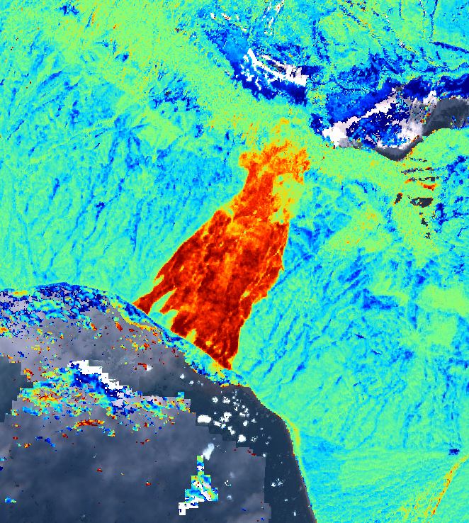
Hazmapper image of the 15 June 2021 landslide into the Sullorsuaq in Greenland.
.
Unfortunately, the timing of the Planet Labs imagery has meant that their satellites have not yet captured the whole of the landslide. However, they did capture an image on 21 June 2021 that provides more detail of the lower portion of the failure:-
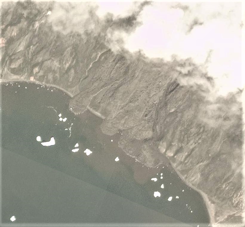
PlanetScope satellite image of the 15 June 2021 landslide into the Sullorsuaq in Greenland. Image copyright Planet Labs, used with permission.
.
The images suggest that the landslide into the Sullorsuaq was a c.2.5 km long failure with flow type behaviour. The Planet Labs image shows multiple lobes of material that have built impressive deposits into the water.
This failure has occurred on a steep rock slope – the Google Earth data suggests that the slope extends from sea level to about 820 m over a distance of about 2.4 km. The upper reaches have a complex topography that might suggest deep-seated gravitational deformations are occurring, but others are better placed to comment on that issue.
.
Reference
Planet Team (2021). Planet Application Program Interface: In Space for Life on Earth. San Francisco, CA. https://www.planet.com/
 Dave Petley is the Vice-Chancellor of the University of Hull in the United Kingdom. His blog provides commentary and analysis of landslide events occurring worldwide, including the landslides themselves, latest research, and conferences and meetings.
Both of these before / after pairs of Sentinel-1 and cloudless Sentinel-2 images should bring additional insight on this landslide: https://www.sentinelvision.eu/gallery/html/95938cf43f004d1797655ee71b0cceae
Is it known what the cause of this was? Rainfall, or melting permafrost perhaps?