
2 July 2021
The cause of the Melamchi disaster in Nepal
Posted by Dave Petley
The cause of the Melamchi disaster in Nepal
The 14 June 2021 disaster at Melamchi in Nepal is the most serious monsoon induced disaster to date of the South Asian summer monsoon. It is believed that the flood that swept down the river killed 20 people. It also caused substantial economic damage both to the riverside communities and to the Melamchi Water Supply Project.
The magnitude of the damage to the town of Melamchi is well-described in a post by Nepal Flying Labs, who have been assessing the site using drones. Their footage of the damage is well worth a visit. This is one of the images that they have posted after the event:-
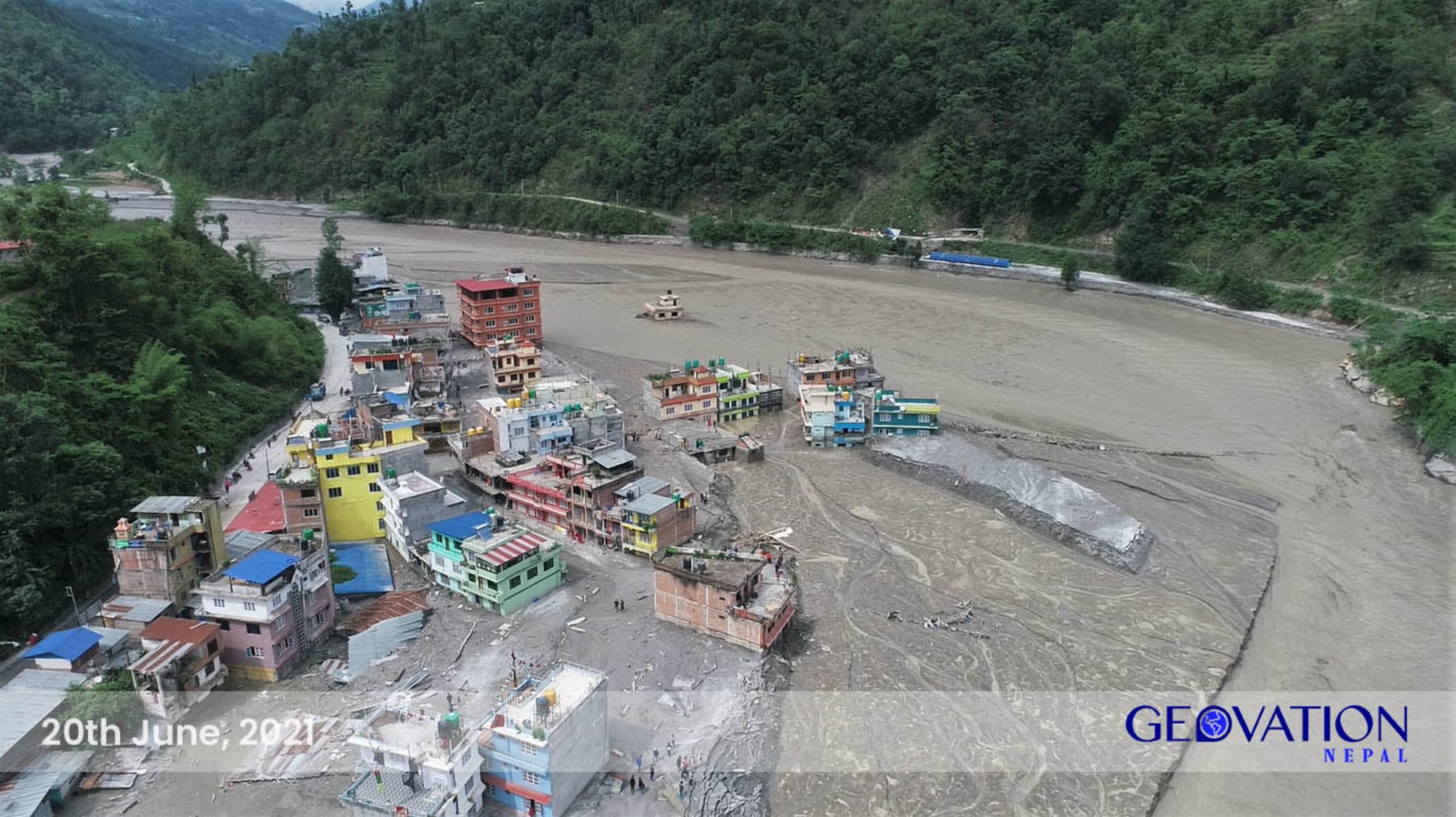
The aftermath of the Melamchi flood in Nepal. Image posted by Nepal Flying Labs.
.
In terms of the Melamchi Water Supply Project, the Kathmandu Post has a good article about the magnitude of the damage. They note that:-
“The project’s headworks site at Ambathan remains buried in flood debris several metres deep.
According to Rajendra Prasad Pant, spokesperson for the Melamchi Water Supply Development Board, it remains uncertain when the debris clearance and restoration works will begin…As per the initial assessment, the project has suffered more than Rs1 billion [about £6 million] worth of damage.
Pant, who is also a senior divisional engineer with the board, said 10 to 15 metres of debris has piled up at the project site and the clean-up work could cost Rs300-Rs350 million [about £1.8 million]. Likewise, the floods have damaged the roads and bridges to the project site and washed away the campsite and construction materials.
There is also another problem. Government officials suspect that the floodwaters and debris could have entered the alternative diversion tunnel of the headworks.”
Understanding this disaster, which we know was caused by the rupture of a landslide dam, is difficult during the monsoon, when cloud cover renders satellite image collection difficult. However, on 23 June 2021 a rare cloud-free day allowed the Planet Labs constellation to collect an image that starts to shed some light on the issue. This is the image:-
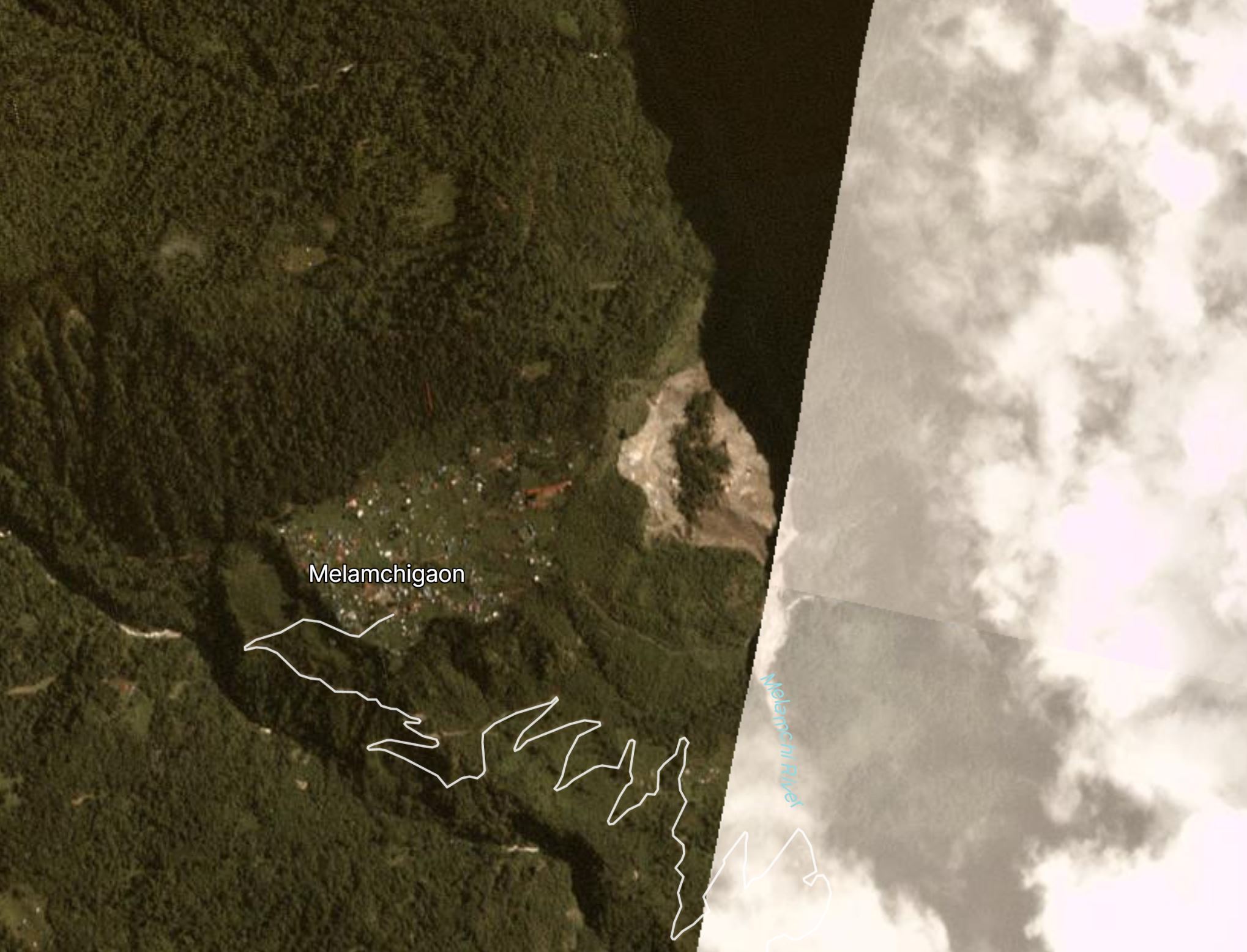
Planet Labs image of the likely cause of the 14 June 2021 Melamchi flood. Image copyright Planet Labs, used with permission.
.
Clearly this is a composite image, with the portion to the east being captured at a time with a much higher level degree of cloud. But the western portion is excellent, and it shows a large landslide (about 500 metres width along the river). It is clear that the flood deposits extend from this point down the Melamchi River. The landslide, which is located at 29.993, 85.553, is not present on satellite images collected before 14 June.
We will need to wait for better images to become available, probably in the autumn when the monsoon withdraws (although we could be lucky sooner than this) to fully understand this disaster, but it does appear that the interpretation that a landslide dam developed during the heavy rainfall, and then breached, is correct.
Reference
Planet Team (2021). Planet Application Program Interface: In Space for Life on Earth. San Francisco, CA. https://www.planet.com/
 Dave Petley is the Vice-Chancellor of the University of Hull in the United Kingdom. His blog provides commentary and analysis of landslide events occurring worldwide, including the landslides themselves, latest research, and conferences and meetings.
Sad that they lost the truss bridge and its approaches. It appears to be in decent shape. I wonder if it will be scrapped or partially disassembled and reinstalled elsewhere along the river.
Thanks Dave, I read your blog after a long gap. I visited the Melamchi site and found some interesting data on the sediment and source. When you have time, let’s have a discussion. You know my email. My best wishes !
Ranjan
Very tough time for the valley, thank you for the writeup. Interestingly we can get some more info from Sentinel-1 too, with the radar being able to see through the clouds. It looks like the cause might have been even further upstream, and the slide at Melamchigaon triggered by the flooding.
Looks like it might have been a landslide dam-breach all the way up at 28.0899, 85.5446. I see a pretty big scour appear in both the ascending and descending amplitude data. With the limited resolution of Sentinel-1 it’s harder to understand the mechanism though.
i think may be global warming and weather changing problem.last year nepal’s to many mountain side snow slide fast fast changing .