
2 June 2020
The evolution of co-seismic landslides: the 2005 Kashmir earthquake
Posted by Dave Petley
The evolution of co-seismic landslides: the 2005 Kashmir earthquake
As I have documented on this site on many occasions, large earthquakes are a highly efficient way to generate landslides in mountainous areas. Landslides kill people directly, but also act to increase the losses from building collapses by preventing access to rescue personnel and impeding the provision of medical assistance. Landslides also prolong the impacts of the earthquake, often for years. Typically landslides occur extensively in heavy rainfall events in the years after the earthquake, causing high levels of damage and loss of life.
The latter point means that understanding the evolution of slopes after large earthquakes is important. There are many unanswered questions – for how long would we expect to see an elevated level of landsliding? What controls this length of time? And how (and indeed why) does the decline in landslide activity actually occur?
A new paper in the journal Geomorphology (Shafique 2020) explores this issue for the 2005 Mw=7.6 Kashmir earthquake in Pakistan and India. This is one of the worst landslide disasters of the last two decades, with thousands of landslide related fatalities. The author has used archive SPOT satellite imagery to map the landslides in the earthquake affected area of Pakistan, in the vicinity of the towns of Balakot and Muzaffarabad, before and after the earthquake.
The results of the study are summarised in this graph:-
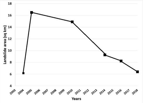
The evolution of the surface area of landslides associated with the 2005 Kashmir earthauke. Image by Shafique (2020).
.
Prior to the earthquake Shafique (2020) mapped 37 landslides in the study area. The first mapping exercise after the earthquake used images dated 20 October 2005, 12 days after the main shock. The number of landslides had increased to 219, an increase of about six times. This image, which I took in early 2006, shows some of the landslides triggered by the earthquake:-
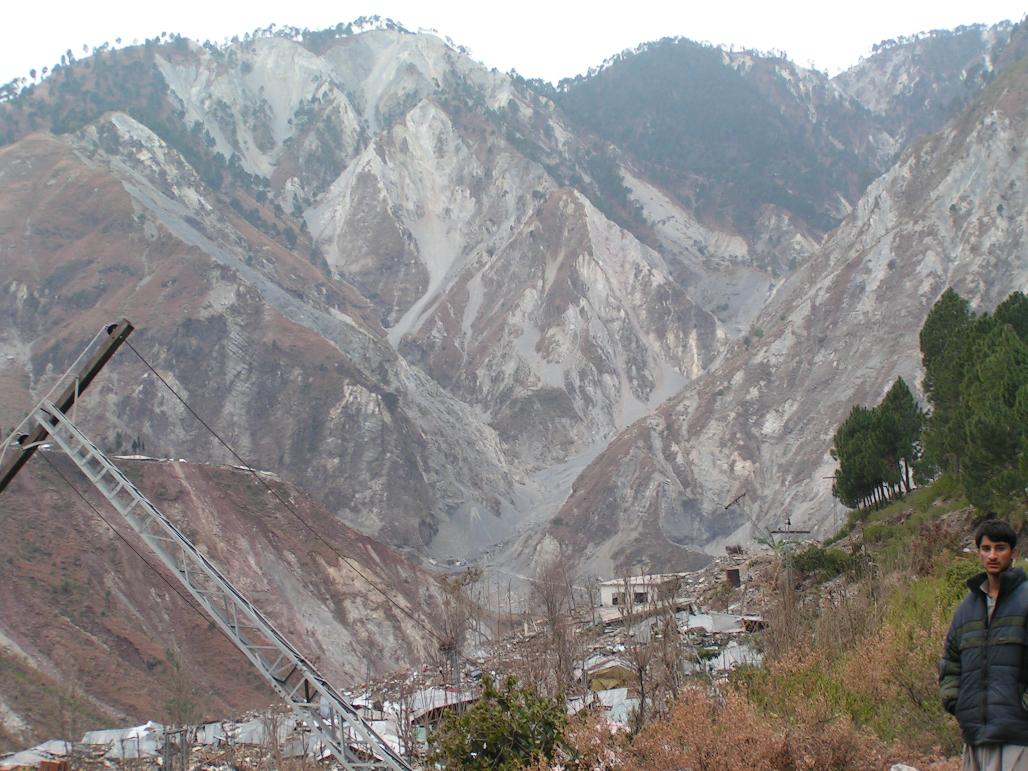
Landslides triggered by the 2005 Kashmir earthquake.
.
The satellite mapping is only able to identify the larger landslides, so the inventory should not be used to determine the total number of landslides triggered. As the graph shows, by the time of the next mapping exercise, in 2010, the number of landslides had started to decline. This reduction accelerated, such that by 2014 the number had reduced markedly. By 2018, the number of landslides was close to the number prior to the earthquake.
Thus, in the Kashmir earthquake case it appears that it has taken in the order of 13 years or so for the level of landslide activity to decline back to pre-earthquake levels. Shafique (2020) rightly highlights that there is an extra factor in play. Other studies have indicated that the number of landslides increased by about 250% in the first summer monsoon (in 2006) after the earthquake. This would certainly accord with my own observations – I was there in May 2006, shortly before the monsoon began, and was deeply concerned by the number of partially failed slopes:
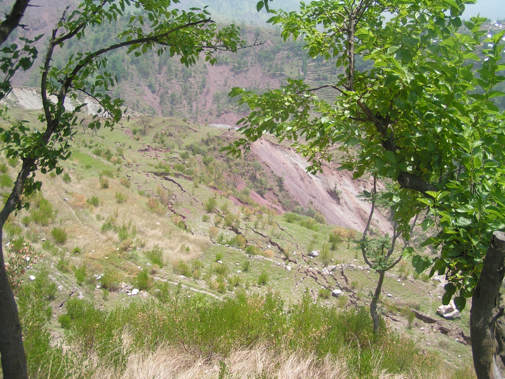
A partially failed slope in Kashmir, taken before the 2006 monsoon season
.
Thus, the peak landslide area was probably higher than the graph from Shafique (2020) might indicate.
The decline in landslide activity from this study has taken longer than has been the case for some other large earthquakes. Shafique (2020) suggests that a major factor in the reduction might be the regrowth of vegetation. Perhaps the climate of Kashmir, which is arid outside of the short monsoon season, means that this process takes longer than in many other mountain chains.
.
On reflection 1: A lucky escape!
Climbers and hikers in Vermont had a lucky escape when boulders tumbled down the mountainside at Smugglers Notch.
.
On reflection 2:
The fall-out from the cliff collapse at Eastchurch in Kent continues. Ironically, the Daily Mirror reports that the house damaged by the landslide was called Cliffhanger.
.
Reference
Shafique, M. 2020. Spatial and temporal evolution of co-seismic landslides after the 2005 Kashmir earthquake. Geomorphology, 362, 107228. https://doi.org/10.1016/j.geomorph.2020.107228
 Dave Petley is the Vice-Chancellor of the University of Hull in the United Kingdom. His blog provides commentary and analysis of landslide events occurring worldwide, including the landslides themselves, latest research, and conferences and meetings.