
26 May 2020
Punatsangchhu I: identifying ancient landslides in high mountain areas
Posted by Dave Petley
Punatsangchhu I: identifying ancient landslides in high mountain areas
There is a new paper in the journal Scientific Reports (Dini et al. 2020, available online) about the use of InSAR to study the movement of the a large rock slope adjacent to the large Punatsangchhu-I hydroelectric plant, which has been under construction for over 11 years. Punatsangchhu I will be a 134 m concrete gravity dam, built to supply electricity to Bhutan and India.
The project is running late and over budget. In 2006 the estimated cost of the project was $554 million. By July 2015 this had reached $1.74 billion. The project was meant to be completed in November 2016, but in April 2017 this had slipped to December 2022, a delay of over six years. BBS reported in February 2019 that the completion date had slipped to 2024; I assume that the budget has escalated as a result.
The primary cause of this delay is a landslide. In July 2013 the east-facing bank of the project site failed and displaced by more than 5 metres. This landslide has required extensive mitigation. However, the project suffered another major, and on this occasion fatal, landslide January 2019.
Google Earth imagery shows the extensive works underway to mitigate the east-facing slope, allowing the abutment of the dam to be completed. The Google Earth image below shows the site in 2017. I have placed the marker at what appears to be the crown of a slope failure, although Dini et al. (2020) suggest that it extends further up the slope:-
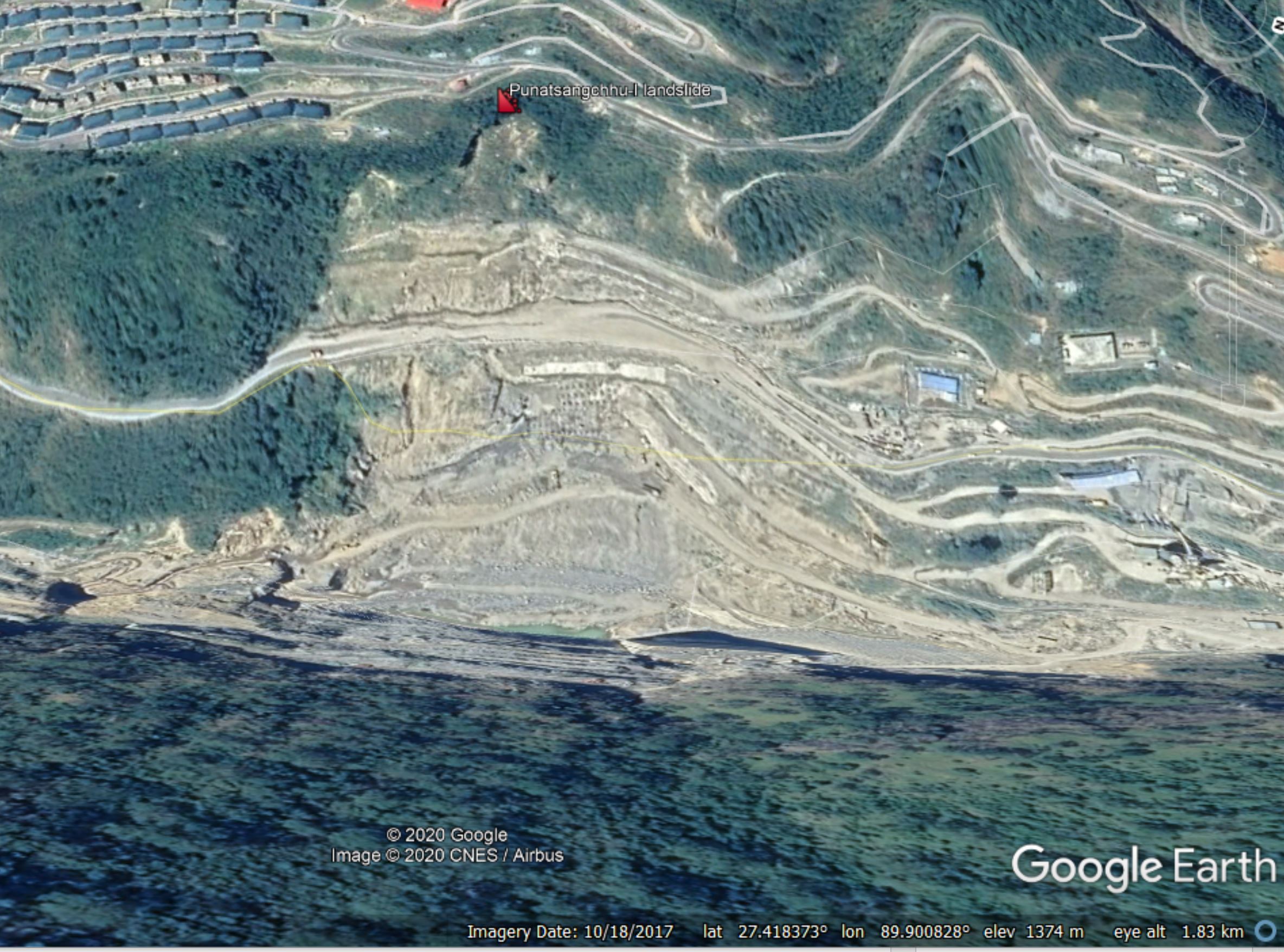
The site of the landslide at the Punatsangchhu I dam, via Google Earth. The image provides the coordinates of the site.
.
The paper by Dini et al. (2020) uses InSAR to monitor the movement of the east-facing slope at the Punatsangchhu I dam site. One of the great things about InSAR is that it allows us to go back in time to look at movements that occurred 15 or more years ago. Their findings make uncomfortable reading. First, the slope was displacing in 2007, even though construction started in 2009. In other words, the dam appears to be located by a large, ancient creeping landslide. Second, portions of the slope have continued to move throughout the construction period, and indeed the area of active displacements continued to expand right through to 2018, the end of the study period. The paper notes that:
Stabilisation measures currently only focus on a small portion of the slope, however, the unstable area is larger than previously evaluated.
And third, that the site is probably a large, ancient landslide. Dini et al. (2020) have found evidence of movement over an area of 8 km2. They include this Google Earth image of the site:-
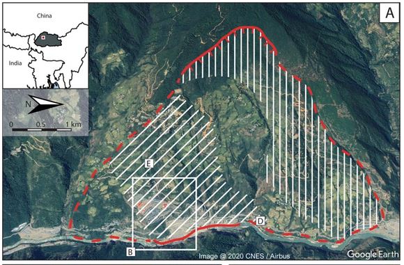
The site of the landslide at the Punatsangchhu I dam, via Google Earth. Image from Dini et al. (2020)., who state that the “hatched area represents damaged rock (diagonal) and undisturbed residual soil (vertical)”. The rectangle highlights the area of the 2013 failure.
.
The InSAR data in Dini et al. (2020) shows different areas of movement across this large slope, covering about 60% of the total area. The authors include that this might be a deep seated gravitational displacement.
This tale is a classic illustration of the importance of site investigation and of understanding the behaviour of the landscape in these high mountain areas. Loyal readers will know that I have highlighted previously that many large hydroelectric schemes in high mountain areas are not managing slopes sufficiently, with tragic and expensive consequences. The Google Earth image below shows the upper portion of the large rock slope. The morphology here, of a steep upper section and then a more planar mid-slope, would always make me deeply suspicious about the presence of an ancient landslide, and indeed when I worked in the Himalayas back in the early 2000s that is how we mapped such sites:-
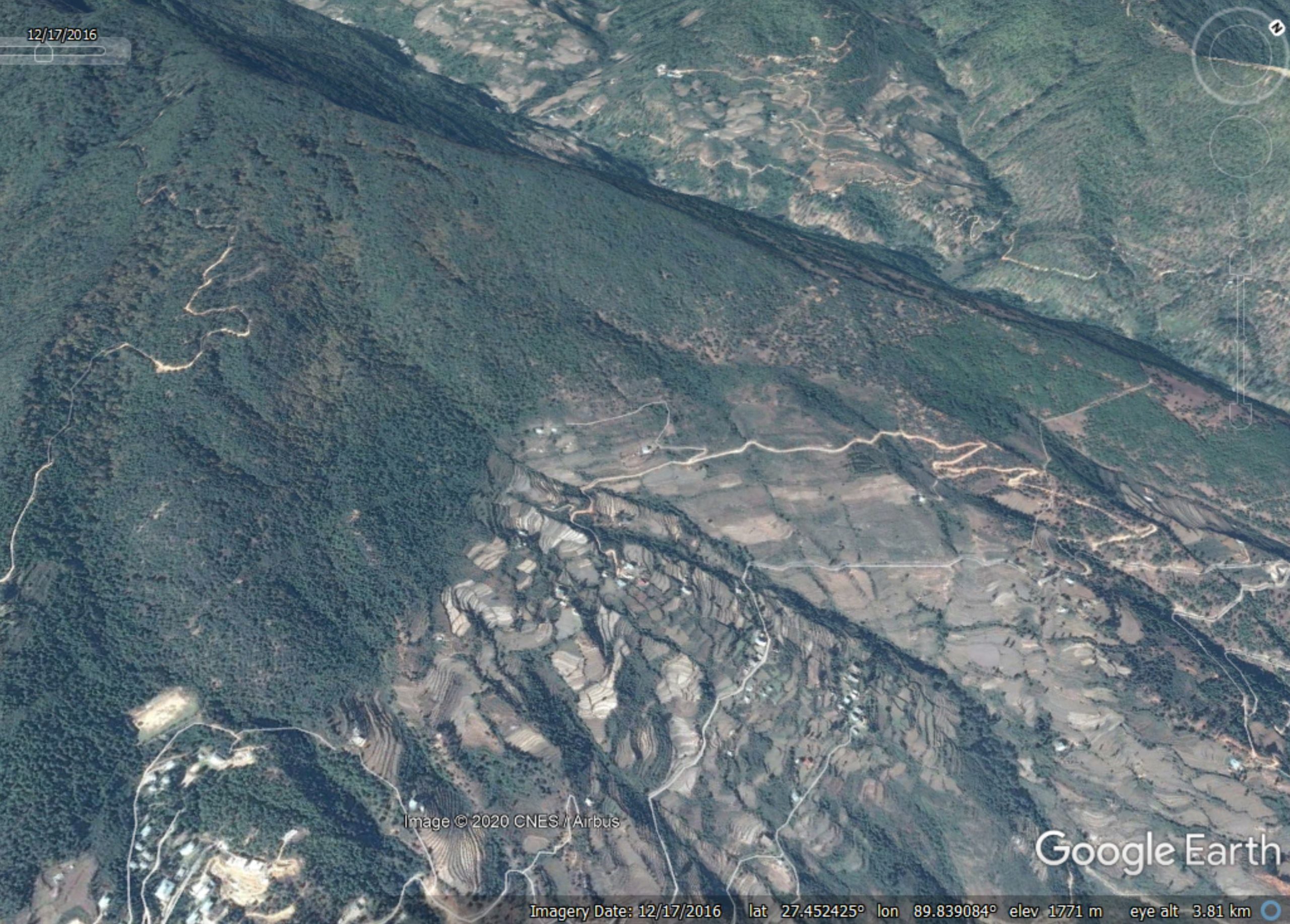
The upper portions of the site of the landslide at the Punatsangchhu I dam, via Google Earth.
.
so, I’m deeply intrigued as to whether this large slope was identified as being problematic before the project started.
.
On reflection 1: landslides at the 2018 tsunami in Sulawesi
The debate about the role of landslides, versus tectonic deformation, in the initiation of the 2018 Sulawesi tsunami rumbles on. A new paper concludes that landslides probably did play a role.
.
On reflection 2: A lucky escape
In Sudbury, Canada a man was rescued after spending more than 12 hours trapped in a landslide. He has a broken arm.
.
Reference
Dini, B., Manconi, A., Loew, S. et al. 2020. The Punatsangchhu-I dam landslide illuminated by InSAR multitemporal analyses. Scientific Reports 10, 8304 (2020). https://doi.org/10.1038/s41598-020-65192-w.
 Dave Petley is the Vice-Chancellor of the University of Hull in the United Kingdom. His blog provides commentary and analysis of landslide events occurring worldwide, including the landslides themselves, latest research, and conferences and meetings.
Hi Dave Petley,
Many thanks for this. Can you say if it is at all feasible to build this dam/ hydro project at this site and it will be able to operate on sustained basis without continued problems of landslides?