
17 April 2020
The Salkantay landslide: wonderful Planet Labs high resolution satellite images
Posted by Dave Petley
The Salkantay landslide: wonderful Planet Labs high-resolution satellite images
Back in February I wrote a series of pieces reconstructing the events that led to the huge and highly destructive debris flow in the Salkantay region of Peru. It is clear that this event was a large landslide from the mountainside that transitioned into the debris flow. My friends at Planet Labs have now succeeded in capturing not one but two fantastic high-resolution images of the site of the initial landslide. The first was captured on 11 April 2020 using the SkySat instrument:-
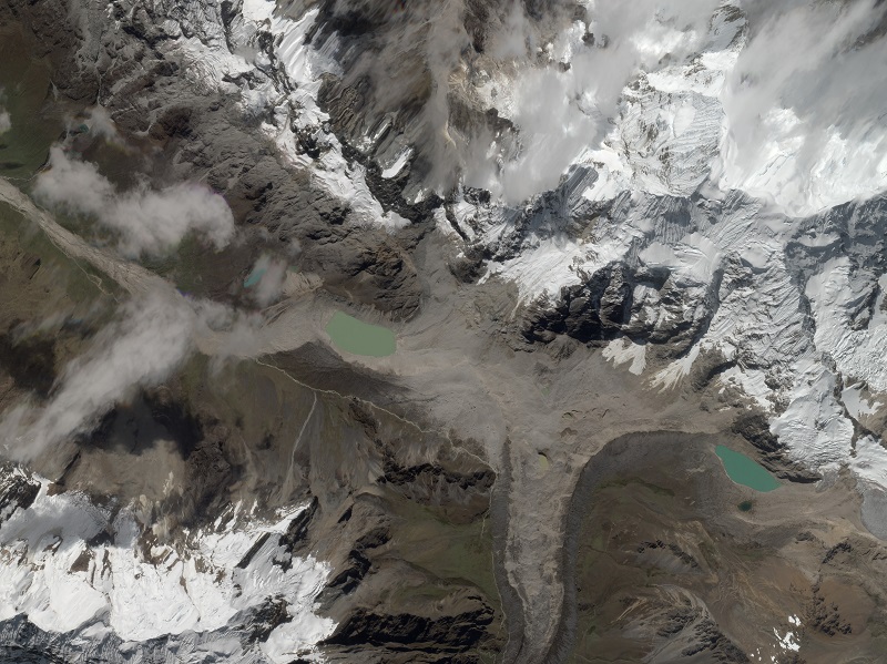
A high resolution SkySat satellite image of the the Salkantay landslide by Planet Labs. Image captured on 11 April 2020, copyright Planet Labs, used with permission.
.
The second was captured on 13 April 2020, also using the SkySat instrument:-
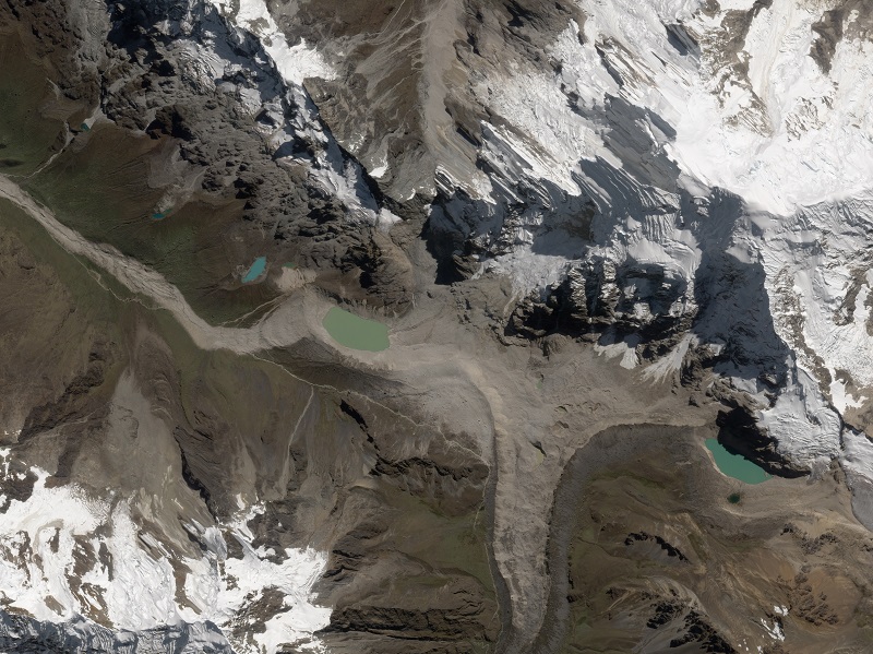
A high resolution SkySat satellite image of the the Salkantay landslide by Planet Labs. Image captured on 14 April 2020, copyright Planet Labs, used with permission.
.
Let’s take a closer look at the source of the landslide. An image captured by Benito Moncado of the site shortly after the landslide suggests that the initial failure was a steep wedge high in the rock mass. This is a more detailed view of the landslide scar and the initial downslope deposit:-
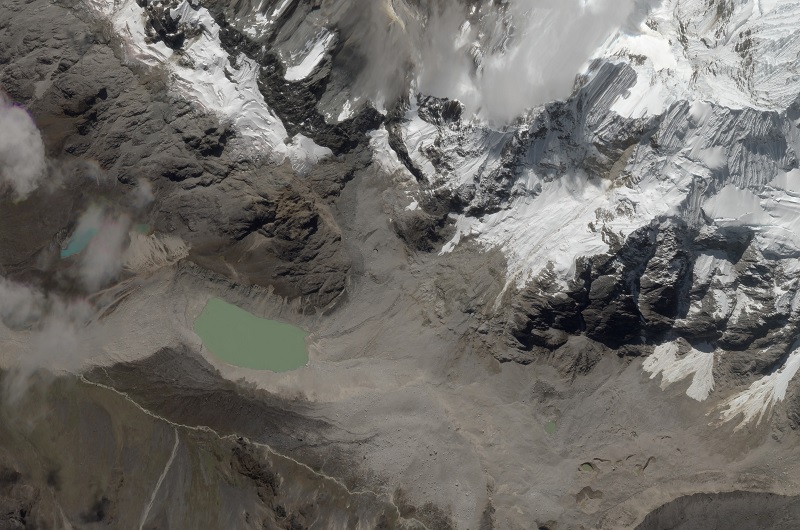
Detail from the high resolution SkySat satellite image of the the Salkantay landslide by Planet Labs. Image captured on 11 April 2020, copyright Planet Labs, used with permission.
.
It is worth comparing this image with the pre-failure Google Earth image of the Salkantay site:-
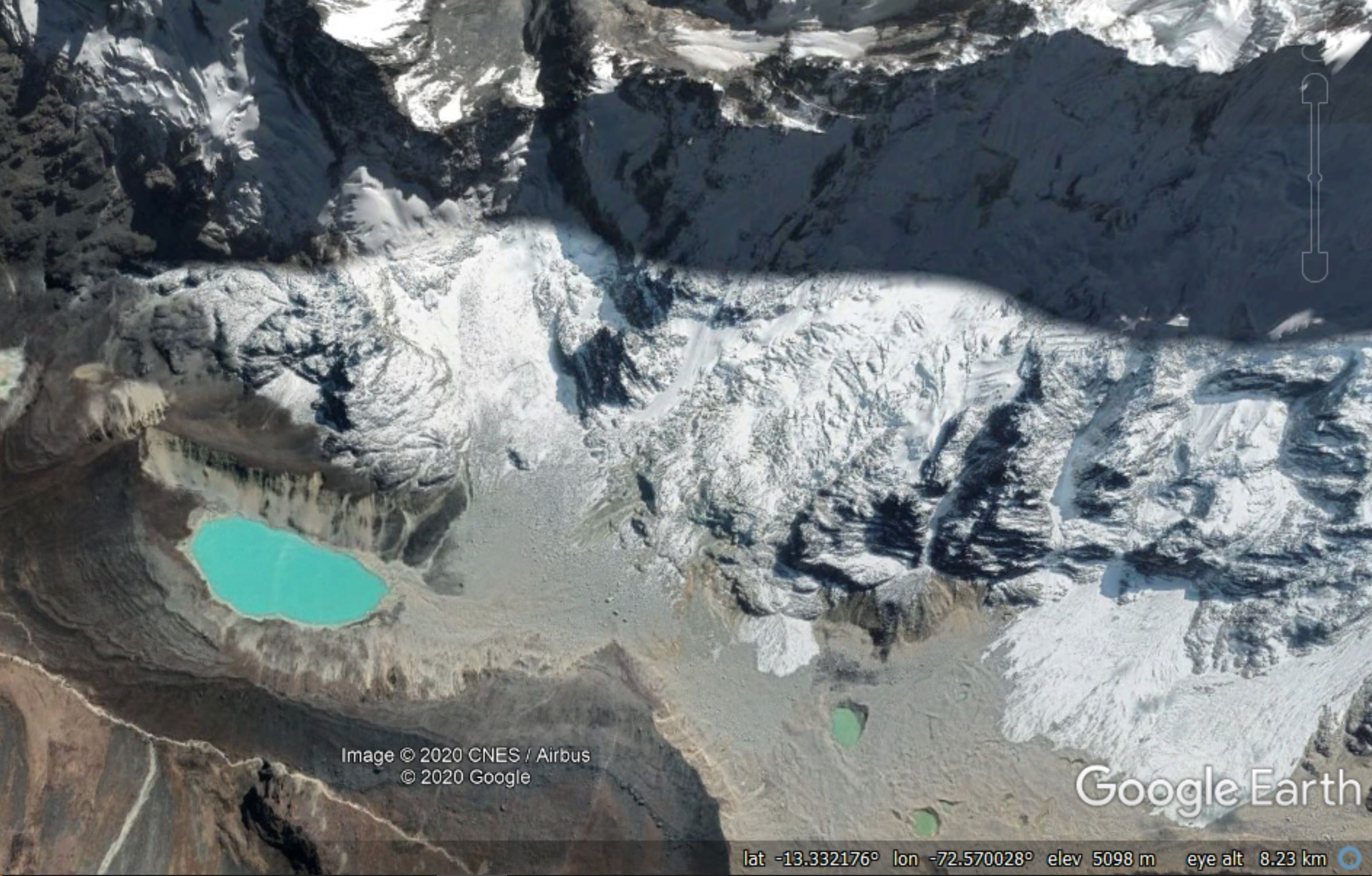
A Google Earth image of the site of the Salkantay landslide
.
Comparison of the two images shows a long section of rock slope that has been removed by the landslide. Interestingly, the 11 April image shows a smaller (but not insignificant) fresh landslide scar near to the crown of the landslide, and a debris trail on the snow, suggesting that some instability is still occurring. The main (February) landslide has planed off the topography down the slope, probably indicating sliding on a joint surface. It is worth noting that this slope is much steeper than it might appear on the satellite image (take a look at the photographs of the site in my earlier post).
I think that the behaviour of the landslide at the foot of the slope is really interesting too, but that is a matter for a future post.
Reference and acknowledgement
Planet Team (2020). Planet Application Program Interface: In Space for Life on Earth. San Francisco, CA. https://www.planet.com/
Many thanks to Robert Simmon of Planet Labs, and to his colleagues there, for tasking the SkySat instrument and for providing the imagery. Their help and support is hugely appreciated.
 Dave Petley is the Vice-Chancellor of the University of Hull in the United Kingdom. His blog provides commentary and analysis of landslide events occurring worldwide, including the landslides themselves, latest research, and conferences and meetings.