9 October 2019
Whanganui: a large landslide on State Highway 4 in New Zealand
Posted by Dave Petley
Whanganui: a large landslide on State Highway 4 in New Zealand
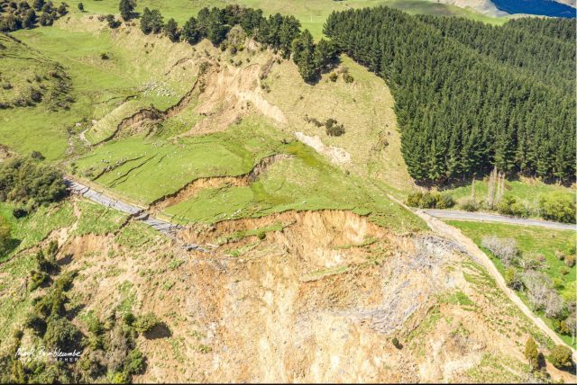
Late last week a large landslide developed on State Highway 4 between Whanganui and Raetihi in Ruapehu district of New Zealand. The landslide, which reportedly has been developing for some time, has destroyed the road, causing considerable local disruption. A local photographer, Mark Brimblecombe, collected a series of images of the landslide via a drone at the weekend. These stunning images capture the size and scale of the failure beautifully.
This image is a good view of the scale of the landslide and the level of damage that it has caused:-

The full scale of the landslide near Whanganui in New Zealand. Image captured by Mark Brimblecombe, posted to Facebook.
.
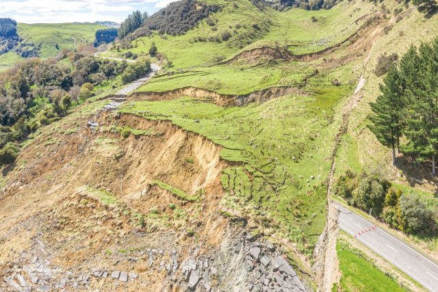
Meanwhile this image shows a different view of the extent of the landslide:-

A panoramic view of the landslide near Whanganui in New Zealand. Image captured by Mark Brimblecombe, posted to Facebook.
.
Note the total destruction of the section of road and also the extent of the tension cracks up the slope (see below), especially on the left hand side. Also worth noting is the landscape in the distance on the far left side – this shows the distinctive features of a potential ancient, now inactive landslide.
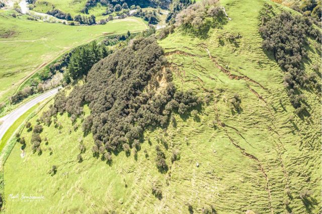
I noted above the full extent of the tension cracks extending up the slope. This image, also captured by Mark, shows this in more detail:-

Tension cracks towards the rear of the landslide near Whanganui in New Zealand. Image captured by Mark Brimblecombe, posted to Facebook.
.
These image suggest that there is a significant volume of material still to be released in this landslide. Reconstructing the road is going to be a very substantial challenge given the magnitude of the landslide, and the volume of partially failure material. To give an idea of the scale of the disruption, RNZ reports that:
“For local logging truck company, McCarthy Transport, the detour was adding an extra 130 to 200 kilometres to their trip, the company’s chief executive Steve McDougall said.”
Acknowledgements
Many thanks to those people who highlighted this to me. My blog really depends on the community effort in which people highlight such events, so your help is really appreciated. Thanks also to Mark Brimblecombe for both collecting the images and for sharing them so openly. They are magnificent.


 Dave Petley is the Vice-Chancellor of the University of Hull in the United Kingdom. His blog provides commentary and analysis of landslide events occurring worldwide, including the landslides themselves, latest research, and conferences and meetings.
Dear Dave,
Thank you very much again for your work for the landslide community!
Regarding the Whanganui landslide I would like to ask whether the cracks are really tension cracks or the cracks are normal faults, indicating a completely different starting mechanism of the (rotational?) slide.
Best regards,
Rainer
Great article!
Thank you very much
Thanks for the interesting info Dave!
I have travelled this road a couple of times at least each year for a number of years to visit family in Wanganui, and there were never any signs of failure. Evidently something has pushed a metastable situation past the tipping point.
As a geologist I looked over Mark’s extensive photos on Facebook, and Google maps imagery, puzzling as to the cause. Two significant features stand out: firstly the basal failure plane appears to be at the top of a low papa cliff along the stream (partly visible in some images) rather than at stream level, suggesting that it is not stream undercutting that has caused the slip; and secondly the pronounced valley feature running back up from the slip, with numerous prominent boulders on the surface. These boulders are presumably volcanic erratics from a higher erosion surface which have residually accumulated at a topographic low point during a prolonged erosion process, as is evident further up the valley system toward Raetihi.
This suggests to me that the area of the slip may possibly comprise a perched and infilled valley feature, which has subsequently been abandoned by the river which has cut a new and deeper course along its existing alignment. In this case the valley fill would be presumed to have failed along the papa base, probably triggered by groundwater, and moved off toward the unsupported and cut off valley end hanging over the current river bed.
However one also has to account for the pronounced knob of material (papa?) sitting in the valley feature, and the extensive tension cracking up the hillside as shown in your second image. These features could be explained in either of two ways IMO.
Either the knob is a relict landslip block within the ancient valley infill, and the tension cracking up the hill is the result of soil slippage off a papa face due to removal of toe support by the slip; or
the valley feature is in fact an ancient landslip headscarp wedge, and the entire block including the slip and the hill with tension cracking are collectively part of a more deep seated ancient slide within the papa. I tried to look at the road cuts in Google Streetview for evidence of disturbance, but the outcrops are mantled in detritus and weeds, and not all that clear.
Some detailed geological mapping could probably resolve which (if either) of these interpretations is correct, and one or two drill holes would not go amiss. It will be interesting to see what the findings are from formal geotechnical investigations.
As to a detour, best option that comes to mind would be to cut a new road around the western side of the depression, entering via its truncated head where it meets the road to the north, and following the eastern side of the depression around the head scarp, securely benched and retained into solid papa. However this would need to be proven first by geotechnical investigation.
I watch this with interest- particularly as I will probably have to travel via Fields Track to visit family at Christmas. This will not be a quick fix.
Roger Evans, Geotechnics Ltd, Auckland