
12 September 2019
Landslides during the construction of the Morehall and Broomhead reservoirs in Sheffield
Posted by Dave Petley
Landslides during the construction of the Morehall and Broomhead reservoirs in Sheffield
I have previously written about the problems that landslide posed to the construction of the Longendale reservoirs in the vicinity of my home town, Sheffield. My local paper, the Sheffield Star, has an interesting article this week about landslides during the construction of two other reservoirs, Morehall and Broomhead, built to supply water to the city in the early part of the 20th Century. The article, written to a highlight a guided heritage walk to the sites on Saturday 21st September, describes major landslide related construction problems, in particular at Broomhead (location is 53.46, -1.60). Part of the article describes these landslides, with the quotations being provided by Mike Atkinson, a former engineer who carried out work on Broomhead Reservoir during his career (Mike will be leading the walk on 21st September):-
In 1924, workers noticed that the hillside towards Yewtrees Lane, north of the Broomhead site, began slipping as an important overflow channel was being dug. “They realised they needed to do something,” says Mike. “They were digging the channel and the ground kept coming towards them.” A trench was dug in short lengths and a drain up to 50 feet deep was put in, filled with rubble. “That, together with removing 400,000 cubic yards of soil from the top end of the slip, seemed to stop the movement,” Mike says.
This Google Earth image shows the Broomhead reservoir. The slope that caused the problems is the forested area on the far side of the lake:-
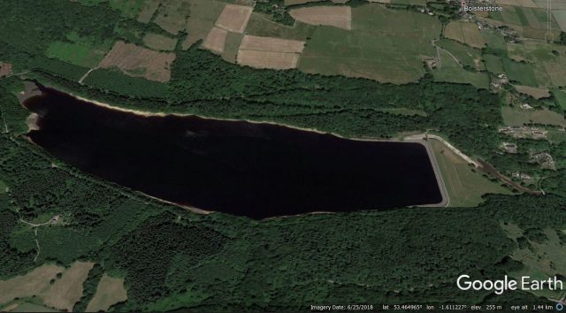
Google Earth image of the Broomhead reservoir
.
The problems at this site are documented in some detail in a paper that was published in the Journal of the Institution of Civil Engineers (Beldelow 1944). This paper names the landslide the “Waldershelf Slip”. The article documents two phases of movement, with the first starting in 1924 during the construction of the overflow works (which can be seen in the image above). Beldelow (1944) includes the following cross section through the site – the slip can be seen on the right side of the diagram, with the inferred slip plane. Note the location in relation to the level of the top of the embankment:-
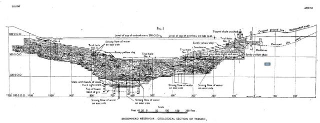
Cross section through the Broomhead Reservoir, showing the landslide on the right hand side. Diagram from Bendelow (1944).
.
To stabilise the landslide, the engineers constructed a drain to extract water from the landslide and they removed about 300,000 m³ of material from the upper part of the slope to reduce the driving load. This work was completed in 1928, and Bendelow (1944) reports that the works appeared at first to have been successful.
However, in April 1930 further movement was observed on the slope, including cracks through the overflow weir. A very detailed investigation was undertaken of the causes of the instability, including trial pits dug to a depth of up to almost 30 metres! These found evidence of slip planes through the bedrock, indicating that the slope consisted of an ancient landslide that had been reactivated by the construction of the dam and associated structures.
To stabilise the slope, the engineers removed a further 125,000 m³ of material, installed drains within the landslide mass, and constructed drains beyond the margins of the landslide to stop water from entering the unstable part of the slope.
To the huge credit of the engineers, these measures proved to be entirely successful, and 75 years after the paper was published the reservoir remains in use.
Reference
Bendelow, L. 1944. Remedial works in connexion with the Waldershelf slip – Broomhead Reservoir. Journal of the Institution of Civil Engineers 22 (6), 95-106.
 Dave Petley is the Vice-Chancellor of the University of Hull in the United Kingdom. His blog provides commentary and analysis of landslide events occurring worldwide, including the landslides themselves, latest research, and conferences and meetings.
Broomhead Reservoir management’s recipe for success:
-A couple of grams of early warning recognition ~
-Add an ounce of prevention~
-Perpetually monitor~
A South American nation’s (whom shares its name with a monotypic nut)
Mine reservoir management’s recipe for Humble Pie:
-Add an ever-increasing mega-tonnage of ineffective cure~
-Allow to boil…..with inattentiveness~