
13 December 2018
InSARNORWAY: a national deformation map for Norway
Posted by Dave Petley
InSARNORWAY: a national deformation map for Norway
Late in November the Geological Survey of Norway launched InSARNORWAY, a new national level deformation map for the whole of the country. This is, as far as I know, the first such national level project, although there have been some proof of concept studies previously. The new map uses multiple epochs of InSAR data (satellite radar data) to generate a map of deformation, accessible via a free web portal. The resource allows the user to map the deformation and to generate graphs of change through time. It is fascinating and exciting.
One of the questions that we have been pondering for a while is the degree to which all rock slopes deform through time, and how fast these rates might be. Sitting below that are nested questions, such as the geological controls, the effects of weather and the evolution of failure. A resource of this type allows us to start to answer these key questions. As an example, I was browsing the maps, and came across this area of deformation near to Aarset (location 62.198, 7.217):-
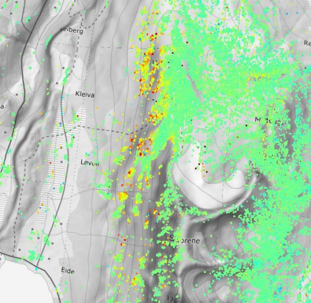
An area of apparent active deformation near to Aarset in Norway, mapped using the InSARNORWAY tool.
.
Here the warm colours are areas of more active deformation. The data suggest that on the west side of a mountain in this area there is some active movement. This is the Google Earth imagery of the same area:-
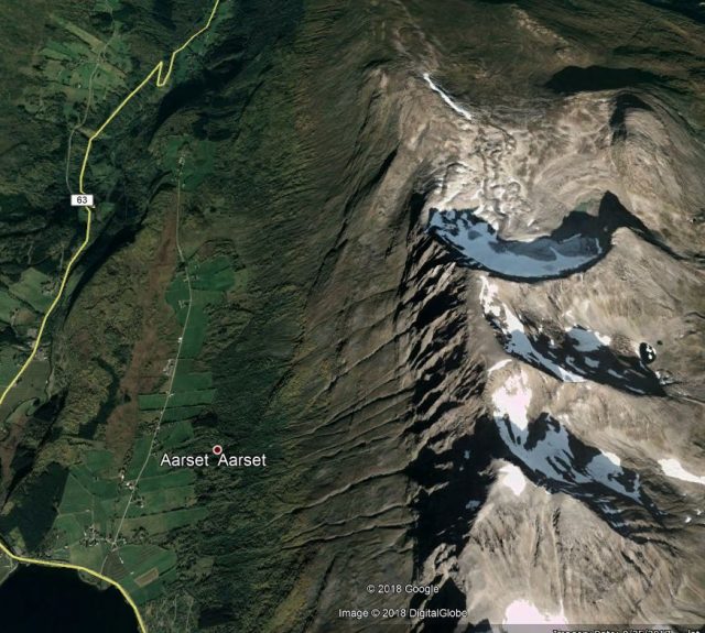
Google Earth imagery of the area near to Aarset in which the InSARNORWAY data suggests active movement is occurring
.
And this is the plot of the data from one of the points in this area:-
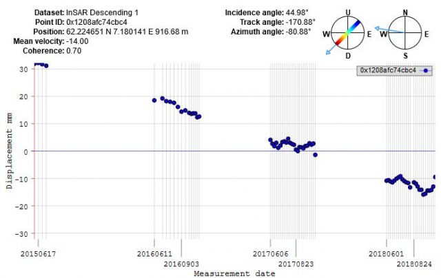
InSARNORWAY data for active deformation near to Aarset in Norway.
.
So the InSARNORWAY data suggest that the over the course of 38 months the slope has moved about 50 mm downwards and towards the west. This is entirely logical in terms of the configuration of the slope. So, on the face of it this appears to be a creeping rockslope. That is not to say that it is dangerous in any way, this is type of creeping behaviour probably quite normal for large, steep rockslopes and so is no cause for alarm. The rate appears to be quite linear with time – again this is not unexpected. But for the first time it is possible to characterise this behaviour over a large area.
Wow!
This of course creates a capability to identify large numbers of creeping rockslopes. It is likely that, in most cases, prior to a large event they will go through a phase of acceleration, so systematic monitoring (perhaps with artificial intelligence) could allow this to be detected. And of course using InSARNORWAY we can now start to understand what is “normal” creep across large areas, allowing us to understand and determine when behaviour is changing.
InSARNORWAY is an extraordinary and very exciting development. I would love to see similar resources for other countries.
 Dave Petley is the Vice-Chancellor of the University of Hull in the United Kingdom. His blog provides commentary and analysis of landslide events occurring worldwide, including the landslides themselves, latest research, and conferences and meetings.
Interestingly, major areas like Mannen or Tafjord area does not show any significant movements. Am I wrong?
This is great although not the first of such national InSAR databases. After the Italian case (Costantini et al. “Analysis of surface deformations over the whole Italian territory by interferometric processing of ERS, Envisat and COSMO-SkyMed radar data.” Remote Sensing of Environment 202, 2017), then – just thinking of TRE Altamira, we processed data all over France, UK (https://site.tre-altamira.com/uk-insar-map/), Japan, California and Denmark. Other people processed data all over The Netherlands and Germany too InSAR data are gaining momentum and soon we will see displacement data all over Europe (!), thanks to the Copernicus Program.
It seems like a lack of data in the Mannen area, rather than a lack of movement?
I believe that none of the national projects that Alessandro refers to have been made freely available to everyone as an operational service with full resolution. InSAR Norway has in average above 6000 measurement sites per square kilometer, i.e. 2 billion measurement locations for the whole country.
It would be interesting to gain insight in the statistics on resolution, degree of operationalisation and data policy for the projects in Italy, France, UK, Japan, California and Denmark.
…….and do not forget the recent and user accessible “The Netherlands” now in Ver. 2.0 the onlu user addressable map available to the public .
https://bodemdalingskaart.portal.skygeo.com/portal/bodemdalingskaart/u1/viewers/basic/