
3 October 2018
High resolution imagery of the Palu landslides
Posted by Dave Petley
High resolution imagery of the Palu landslides
DigitalGlobe have now released high-resolution imagery of two of the Palu landslides, triggered by the 2018 Sulawesi earthquake. This is available as a “before and after” slider on the CNN website (and elsewhere). The level of detail is remarkable, and we are now starting to get an idea of the mechanisms and motion of the landslides.
This image, from DigitalGlobe via CNN, shows the aftermath of the Petobo landslide, which I featured yesterday:-
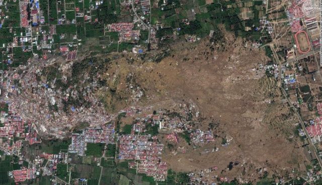
The landslide at Petobo, one of the Palu landslides. Image from CNN via DigitalGlobe, a Maxar Company.
.
As I noted yesterday, the landslide, which moved from east towards the west, appears to be a planar flowslide of some type, with a very strong lobate form away from the source. Note that the landslide debris itself is an extraordinary combination of soil and debris, and houses and buildings, all compressed together. The total loss of homes is very high, but it is hard to know as to the likely level of human casualties. There are multiple tension cracks in the headscarp area, and this will be a very challenging site in the next heavy rainfall event.
meanwhile, the smaller landslide at Balaroa, the site closest to the city centre, is also terrible. On this occasion the landslide moved from west to east, and again a large, mostly evacuated, source area can be seen. There is a raft of mostly intact debris and vegetation downslope, and then an extraordinary compression zone of destroyed buildings. The slide is about 1 km long. The level of loss is once again high, but the number of fatalities is difficult to determine.
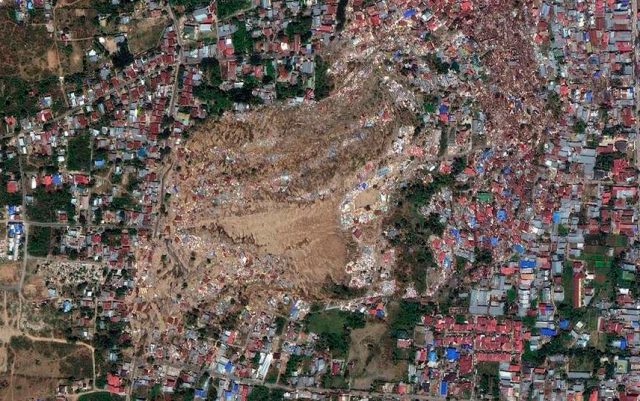
The landslide at Balaroa, one of the Palu landslides. Image from CNN via DigitalGlobe, a Maxar Company.
.
It is worth noting that for the survivors this type of event is worse than the more normal building collapse. In an earthquake-induced building collapse people may lose their property and most of their possessions, but at least sometimes still have their land. In the case of a landslide they typically lose property, possessions and the land that they inhabited or owned, as the image above shows. This is devastating in the long term.
InSAR data of the area affected by the earthquake is now becoming available, which shows the line of the fault. As expected, this data suggests that these big landslides are close to the fault trace. Unexpectedly, the data also suggest that the fault that ruptured extends into the bay north of Palu, but then steps onshore to run through the isthmus rather than offshore. This step may explain the tsunami, rather than it being a submarine landslide (the jury remains out on that one). Rupture appears to have been strongly directional, propagating south from the epicentre at the northern end of the earthquake zone. The upshot is that Palu suffered a bullseye hit from a large earthquake, with a strong directional component. It is no wonder that the level destruction is so high. In that context the number of human casualties currently reported seems surprisingly low to me.
 Dave Petley is the Vice-Chancellor of the University of Hull in the United Kingdom. His blog provides commentary and analysis of landslide events occurring worldwide, including the landslides themselves, latest research, and conferences and meetings.
I located the Petobo slide area on Google Earth and made some rough measurements, following a road that bisects the length of the slide. The length of the area scraped clean if ~2500′, ranges from 273′ – 200′ elevation, slope ~2.8%. It’s another 4650′ to the slide face, elevation 200′ – 129′, slope 1.5%. Slope for the next 500′ on that line is 1.2%, and a road populated with more substantial development runs across the direction of the slide.
Bonus: Street View is available along that road and many others. It’s fascinating to see up close.
Reference: The running track at upper right margin of photo in this post is at -0.936 lat / 119.923 long
Cheers /ma
There was a remarkable snippet on BBC TV news of a mostly-intact field of rice which had slid downhill almost a kilometre…
IIRC, current thinking is that the off-shore fault took a significant off-set which brought it ashore and also triggered the local tsunami. Combined with the tapering topography, this was ‘worst case’.
:-((
Quite a fascinating set of images here at Reuters:
https://graphics.reuters.com/INDONESIA-QUAKE/010080MZ19R/index.html
…especially the aerial before-after photos that seem to capture the slip displacement of the fault passing through the city.