
19 September 2018
The Kodagu landslides in Karnataka, India: Planet Labs imagery
Posted by Dave Petley
Kodagu landslides in Karnataka, India: Planet Labs imagery
On 15th to 17th August, the Kodagu area of Karnataka in SW India suffered exceptional monsoon rainfall, inducing floods and landslides. Reports suggest that over 200 mm fell per day on three successive days. There were many fatalities and a high level of damage was inflicted. There has been considerable controversy in India as to the cause of the Kodagu landslides, with suggestions ranging from environmental degradation, release of water from a network of dams and even a previous earthquake. A team has been established to examine the causes; it will be interesting to see what they find.
These landslides received comparatively little attention in outside of India, but they were a very substantial event. Raj Bhagat P and Samrat Basak from WRI India, used Copernicus Sentinel data to examine the impact of the landslides.The Planet Labs image below shows the heart of the area affected by the landslides, prior to the event (image from 11th May 2018) – this is an area of forest with some human modification for farms and roads. It is hilly, but not mountainous:-
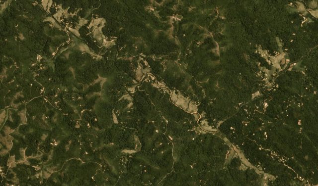
Pre-event Planet Labs imagery of the area affected by the Kodagu landslides in SW India in mid-August. Image courtesy of Planet Labs, used with permission. 4-band PlanetScope scene dated 11th May 2018.
.
Compare that with the PlanetLabs image below, collected on 15th September 2018:-
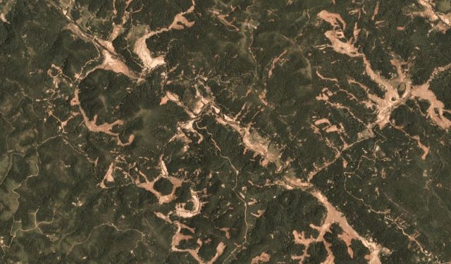
Post-event Planet Labs imagery of the area affected by the Kodagu landslides in SW India in mid-August. Image courtesy of Planet Labs, used with permission. 4-band PlanetScope scene dated 15th September 2018
.
The difference is dramatic – it is clear that many landslides were triggered across this area. These look to be shallow slides that have transitioned into channelised flows. In many cases multiple landslides have coalesced into the same channel. The area below is such an example:-
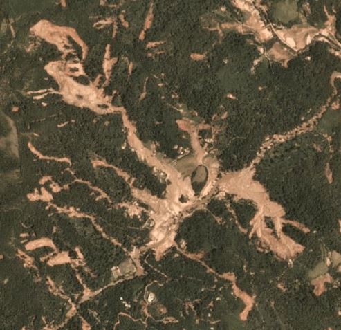
Detailed post-event Planet Labs imagery of the area affected by the Kodagu landslides in SW India in mid-August. Image courtesy of Planet Labs, used with permission. 4-band PlanetScope scene dated 15th September 2018
.
Each of the channels here has been fed by multiple smaller landslides, forming very dramatic channelised flows. There is extensive sediment deposition on the valley floor, which will have been disastrous for the farmers in this area. The reports of the loss of infrastructure is explained, at least in part, by the extremely damaging effects of these flows.
Acknowledgement and Reference
Kishor Cariappa first highlighted the extensive nature of these landslides, as evidenced by satellite imagery, on the website Kodagu Connect. Interpretation of satellite images of this event was first undertaken by WRI India, using modified Copernicus Sentinel data [2018]; Processed by Raj Bhagat P, Samrat Basak.
Planet Team (2018). Planet Application Program Interface: In Space for Life on Earth. San Francisco, CA. https://api.planet.com
 Dave Petley is the Vice-Chancellor of the University of Hull in the United Kingdom. His blog provides commentary and analysis of landslide events occurring worldwide, including the landslides themselves, latest research, and conferences and meetings.
Did you see this video of the Cebu landslide?
https://www.youtube.com/watch?v=Tgg2umsWDH8
Hi,
Please review your acknowledgement section. The satellite image based analysis for Kodagu was brought by myself(Raj Bhagat Palanichamy) and Samrat Basak of WRI.
Photo Essay link for the same:
https://t.co/8l6NrNWeCr
Kodagu connect reprinted our article with proper credits. Please do the same.
Please correct rainfall amount per day from 200 m to 200 mm. Thanks.
https://www.thenewsminute.com/article/no-link-between-landslides-kodagu-and-earthquake-witnessed-july-say-scientists-87176
Could you please review your acknowledgements. The news / Images were produced by WRI India (Processed by myself) which was reposted by Kodagu Connect. They did a good job in acknowledging us as well.