
9 February 2017
Review of a paper: the Dongla Landslide in Sichuan, China
Posted by Dave Petley
Review of a paper: the Dongla Landslide in Sichuan, China
In a paper just published in the journal Landslides (Luo et al. 2017), my colleague at the University of Sheffield Lis Bowman and her co-authors from China examine the fascinating Dongla Landslide in Sichuan, China. This is an ancient landslide mass located in Muli County (at 28.361, 100.629 if you want to take a look on Google Earth). The Google Earth image below, taken in 2015, shows the location:
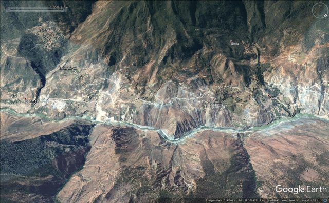
Google Earth image of the Dongla landslide in China
.
On the left side of the image, close to the place marked Lanman, there is a new 500 kV electricity substation. To provide access to this, and to improve road links through the area, a 134 m bridge was constructed across the Shuilou River at this location in 2011. Unfortunately it was not appreciated that this site is a part of a very large, ancient landslide mass. Later in 2011 a part of the Dongla landslide reactivated. Involving 6 million cubic metres, the progressive development of this landslide deformed the bridge. This area is clearly shown in the 2013 Google Earth image, although note that the apparent deformation of the bridge is due to the terrain matching algorithm used by Google, not the landslide!
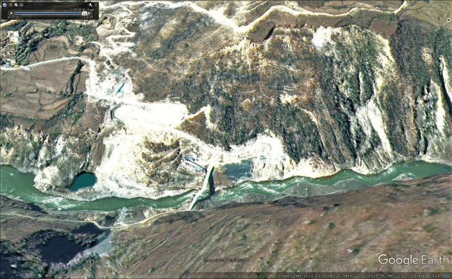
Google Earth imagery of the reactivated portion of the Dongla landslide
.
The paper describes a fascinating history of this landslide. Between 1990 and 2000 the area was subjected to extensive small-scale illegal gold mining that has left the terrain and vegetation scarred and damaged. These pits have provided pathways for rainwater to enter the landslide. But excavation of the toe of the slope for the bridge and road appears to have reactivated a portion of the landslide; for example in December 2012 the mass moved up to five metres. Luo et al. (2017) provide some fascinating images of the development of damage in the bridge as a consequence, including this one:
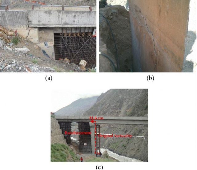
Bridge damage from the Dongla landslide, from Luo et al. (2017)
.
Monitoring of the landslide showed a highly seasonal movement pattern, with enhanced periods of motion being associated with increased rainfall. The movement occurred on shear surfaces located at about 20 m depth. In order to provide a short term reduction in movement the slope toe was reinforced with a large toe weight, consisting of 80,000 cubic metres of soil, which reduced the rate of movement, allowing access to the substation by heavy machinery. However, this was not a permanent fix, and by February 2014 the rate of movement was once again increasing. In 2015 the bridge was removed with explosives, and a new site was identified. The landslide continues to pose a threat though, requiring monitoring, with the major hazard being the potential to create a landslide dam.
This is a fascinating study that emphasises the importance of proper engineering geological investigation. These ancient landslide bodies occur widely in high mountain environments, and repeatedly cause major impacts to infrastructure projects. Identifying them requires real skill – and the use of engineering geomorphology – but the time and effort is well-spent. As the study by Luo et al. (2017) shows, failing to identify them can be both extremely expensive and cause long-term impacts. It is best not to unleash the dragon. Once it is out of the cage it can be very hard to contain it.
Reference
Luo, G., Hu, X., Bowman, E.T. and Liang, J. 2017. Stability evaluation and prediction of the Dongla reactivated ancient landslide as well as emergency mitigation for the Dongla Bridge. Landslides. doi:10.1007/s10346-017-0796-9
 Dave Petley is the Vice-Chancellor of the University of Hull in the United Kingdom. His blog provides commentary and analysis of landslide events occurring worldwide, including the landslides themselves, latest research, and conferences and meetings.