18 February 2016
An update on the Yaglidere Landslide, including another video
Posted by Dave Petley
An update on the Yaglidere Landslide
Yesterday I blogged about the Yaglidere landslide. I have tracked down a second video on Youtube, in some ways even more dramatic than the original:
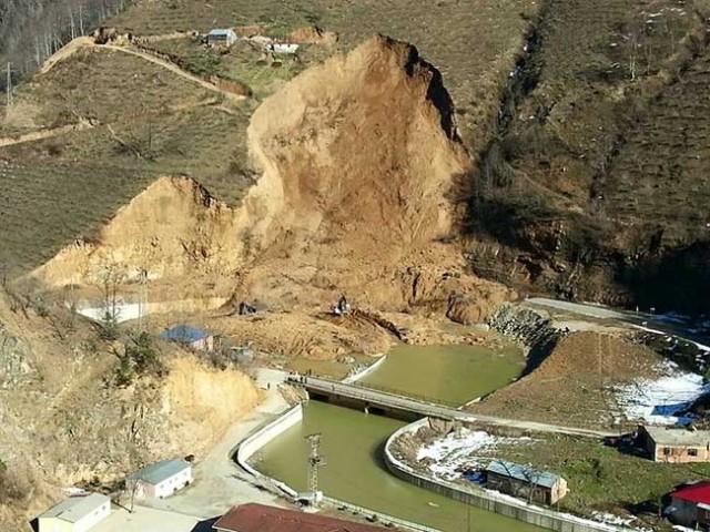
The video of the Yaglidere landslide was posted on the website of the Yaglidere Gazette (I’m sure you are all avid readers already), who also has a news report (in Turkish) about the landslide, which includes this image of the aftermath:

Yaglidere landslide via the Yaglidere Gazette
.
This image shows that the landslide was on the outside of a river bend. It appears that there might have been some works going on at this site prior to the failure, but this may have been clearance of the debris from earlier landslides.
Caner Zanbak via a comment on my original post has very kindly provided this information:
The landslide referred in the video at Yaglıdere, Giresun, Turkey (37T467890E, 4503640N at 650 m MSL [I am not sure how to interpret this location – D]) occured on 4 February, 2016 following quick melt of accumulated snow by heavy rainfall events. Based on the information provided by engineering geologist Assoc. Prof. Hakan Ersoy ([email protected]) of Karadeniz Technical University in Trabzon, Turkey, surface morphology at the landslide area reveals likely presence of large-scale paleo-landslide mass overlying the highly weathered (exfoliated, arenaceous, argillaceous) intrusions of the upper Cretaceous Kaçkar Granitoids. The recent landslide has taken place in the paleo-landslide mass.
As seen in the related video showing the ultimate failure, the landslide was triggered by the earlier erosion of the natural slope toe by the river and progressed upwards under a combination of inclined base and pseudo-circular failure mode. The height of the near vertical exposed slide surface is approximately 20 meters. Please note that another slope on the left side of the current landslide is prone to a similar failure..
———-
Regarding the Google Translation of the news article: below is a better (?) English version:
“Recently, the soils softened due to rainfalls caused a landslide in Giresun–YAĞLIDERE [Yaglidere in the English spelling]. A mountain-size mass landed almost flat in a landslide occurred along the roadside. The foothills started to break at the beginning followed by a large mass landing on the river bed. Those who were at the roadside barely saved their lives.”
This provides a much better insight into the events associated with the Yaglidere landslide, and I very much appreciate his help.


 Dave Petley is the Vice-Chancellor of the University of Hull in the United Kingdom. His blog provides commentary and analysis of landslide events occurring worldwide, including the landslides themselves, latest research, and conferences and meetings.
37T467890E, 4503640N is a location in metric Universal Transverse Mercator. Google Earth can be set to show your position in UTM (both metric and English units), but the search function doesn’t understand UTM.
There are conversions from UTM to lat/long available, but many are limited to some regions and may not cover Turkey.