
16 January 2014
Aoraki / Mount Cook: A new survey of its height after the 1991 landslide
Posted by Dave Petley
The 1991 Aoraki / Mount Cook rock avalanche
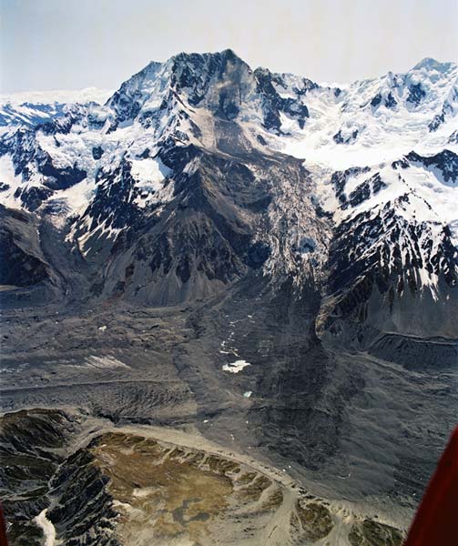
On 14th December 1991 a rock avalanche occurred on Aoraki / Mount Cook in New Zealand, travelling a total distance of 7.5 km. The slide, which had an estimated volume of 12 million cubic metres, removed the top of the mountain, although forunately it did not cause any loss of life or property. GNS have a short information page about the landslide, which includes this (famous in the landslide-world!) image:
http://www.teara.govt.nz/en/photograph/8785/aorakimt-cook-landslide
..
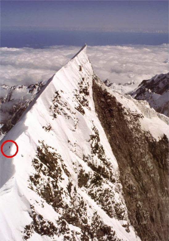
The landslide was believed to have removed about 10 m from the summit of the mountain, leaving a knife-edge ridge as shown in the image below, taken by Mauri McSaveney, also of GNS. The circled dot is a climber for scale:
http://juliansrockandiceblog.blogspot.co.nz/2014/01/the-changing-height-of-mount-cook.html
..
The 2013 resurvey of the height of Aoraki / Mount Cook
It was inevitable that such a knife-edge ridge would undergo erosion, reducing the height of the mountain further. However, until now no proper survey had been undertaken of the height of the mountain. GNS, working with the University of Otago, have just completed an expedition to accurately record the height of Aoraki / Mount Cook 22 years after the event. This is described in a very nice post on Julian’s Blog, and there is a Youtube video of the work as well:
..
..
The conclusion of the research is that the height of Aoraki / Mount Cook is now 3724 metres above mean sea level, meaning that the mountain is now 30 m lower than before the rock avalanche.
If you are interested in the science behind the work, it is well described on a University of Otago project web page.
 Dave Petley is the Vice-Chancellor of the University of Hull in the United Kingdom. His blog provides commentary and analysis of landslide events occurring worldwide, including the landslides themselves, latest research, and conferences and meetings.
Very interesting, looking at that picture of the Mt. Cook Landslide makes me think of the Usoi natural dam in Tajikistan. But i guess an earthquake didn’t cause this rock slide. Maybe it was a birds weight that set it off, haha. Thanks for sharing.
So where do climbers now consider the summit? Surely they don’t walk to that spit of snow/ice?