5 April 2011
An interesting landslide on Highway 101 in California
Posted by Dave Petley
Thanks to Drew Barber and to Brian Huggett for bringing this one to my attention – and apologies to them for my tardy post!
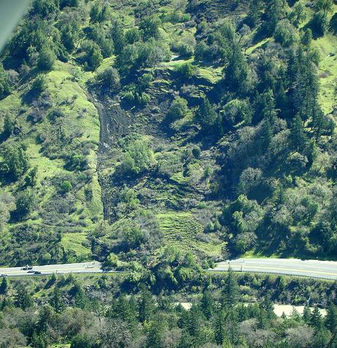
California has suffered a prolonged period of rainfall in recent weeks, which unsurprisingly has resulted in significant landslide activity. Of particular note is a slide on Highway 101 in Humboldt County about 8 km to the north of Garberville that occurred last week. This image, collected by Felix Omai, shows the landslide rather well:
Note the cars on the lower left for scale. There are two great galleries of images of the landslide. First, Felix Omai has a Flikr gallery that has views of the slide from both the ground and the air, including the clean up operation. Second, Redheaded Blackbelt has a commentary as well, also with some great images (but can I caution that this site takes a counter-culture view that I am not endorsing) here . The latter site also has a very interesting commentary from the perspective of a land owner on another landslide in this area, which is worth a read.
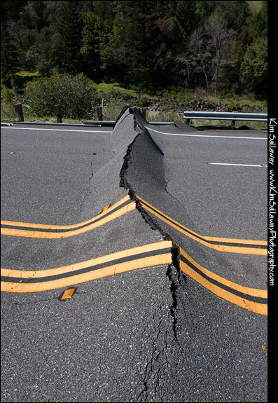
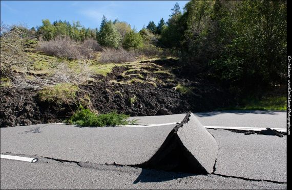
In many ways the most interesting aspect of this landslide is the deformation that it has caused to the roadway. As the landslide has moved onto the highway the asphalt appears to have effectively delaminated from the sub-base. The landslide effectively imposes a vertical load and a horizontal compressional force on the surface layers. The result is a series of fascinating features, as shown in the images below (from here):

Reports suggest that the landslide has now been cleared, the surface has been resealed and the road reopened.


 Dave Petley is the Vice-Chancellor of the University of Hull in the United Kingdom. His blog provides commentary and analysis of landslide events occurring worldwide, including the landslides themselves, latest research, and conferences and meetings.
Dr. Dave,
I appreciate your linking to my blog. You made a slight error that, as you are a landslide blog, I thought you might want to correct. The post on the perspective of landowner is about another landslide that occurred about 10 miles from the one shown by Felix Omai’s and Kim Sallaway’s equally wonderful photos. The North Coast is currently beset by landslides. A small community near Klamath is currently trapped behind a slide without power.
Although, I do write about and photograph marijuana occasionally, (please forgive me for teasing a bit) I promise that my belief that prohibition is pointless isn’t contagious. Many people who disagree, read my site, and still enjoy the photography and information about other subjects that interest me.
Sign me,
The really quite staid Kym Kemp
By the way, if you are interested there is video and photos of a another new slide coming into an area of our county called Dobbyn Creek. http://wp.me/p7Qmm-1Nr
The below YouTube video shows pavement ‘delamination’ during the Sendai tsunami, which I found most interesting. It’s near the end of the video tho. (turn down the sound as the radiation sensor’s beeping is most annoying, starting at about 3 minutes in. It’s also available in 720 and 1080, tho 360 loads faster and is adequate viewing.)
http://www.youtube.com/watch?v=yp9iJ3pPuL8&feature=player_embedded
Otherwise, it’s an interesting look see at a WWIII type landscape !
Actually the delamination is at 6:30 into the video, the middle.
This is a good blog of the landslide. Especially about photos, those are very good, but I think if each photo have the information about the condition, type and the cause or the trigger of landslide. Thanks.