
27 October 2010
The Mantawai islands tsunami and the eruption of Mount Merapi in Indonesia
Posted by Dave Petley
Indonesia is today trying to deal simultaneously with two substantial natural hazards of a rather different nature. The earthquake on Monday 25th October triggered a localised tsunami in the Mentawai islands, close to the epicentre, the Reuters Alertnet reports killed 108 people and has left a further 502 people missing.
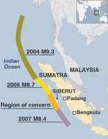
The data on the earthquake available on the USGS website suggest that this was a Mw=7.7 event at a depth of about 21 km. The earthquake occurred on the subduction boundary between the Australian and Sunda plates. This is the same fault system that has generated a series of earthquakes in recent years, the most notable of course being the 2004 Boxing Day tsunami generating event. This area has been known to be due a large earthquake in the current series – see for example this article on the BBC website, which provided the map shown to the left, identifying the area of concern.
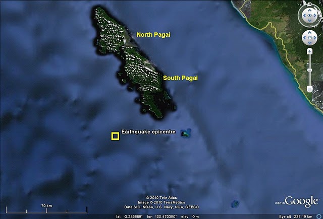
The location of the earthquake was such that the potential for widespread damage from the event itself was limited given the lack of population in the immediate vicinity. However, the potential for a local tsunami was immediately identified and warnings were issued. The tsunami itself appears to have primarily affected the islands of North and South Pagai (see map below). The charity Surfaid is very active on the Mentawi islands, and of course some of the villages affected by the tsunami are surfing sites, so unsurprisingly it thus has some good reports about the event itself. The earthquake struck at 9:42 pm local time – i.e. when it was dark – which of course will have reduced the likelihood of seeing the onrushing wave, and the likelihood of escaping from it somewhat lower.
At the moment there is little information as to the likely cause of the tsunami. It is possible that this was directly generated by the earthquake, or that it may be associated with one or more submarine landslides. However, the GDACS service has a quite excellent but poorly-advertised resource online here that provides an animation of the likely tsunami generated by the fault itself here. The animation should be visible below:

The resultant wave heights are shown below:
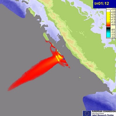
Their modelling data suggests arrival wave heights of 0.1 to 0.5 metres, somewhat lower than actually reported (Surfaid suggests 2 to 3 metres), but note that this could be any one of the run-up affect when the wave reaches the coast, deficiencies in the model (which inevitably is only taking a very broad view at this stage) and the impact of events such as submarine landslides.
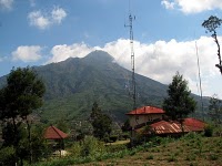 Meanwhile, Mount Merapi has now started erupting, and reports suggest that 25 people have been killed, probably by pyroclastic flows if the reports are correct. Up to 50,000 people are being evacuated. This has the potential to be a large eruption. There is a good set of webcams available here (click on the icons on the map), although in this tropical environment clouds are inevitably a problem. Note that it takes a minute or so for the image to download, so be patient. The image to the left is one taken.
  Dave Petley is the Vice-Chancellor of the University of Hull in the United Kingdom. His blog provides commentary and analysis of landslide events occurring worldwide, including the landslides themselves, latest research, and conferences and meetings.
weather near volcano http://theweatherland.com/index.php?&show;=4&all;=1&lon;=110.467⪫=-7.567&hpl;=06&country;=&city;=Banyarrejo&lat2;=-7.552420449639623&lon2;=110.48641204833984&cf;=undefined&z;=12
Sir,A fatal landslide in Kerala (27 October, 5.30 pm) in Puchapra, near Vellimattam, Idukki district. Three people died.In the vicinity of this one which killed 3 people, 7 debris flows occured. No english news links were available. These details are from Mathrubhumi daily (http://www.manoramaonline.com/cgi-bin/MMOnline.dll/portal/ep/malayalamContentView.do?contentId=8152135&tabId;=11&contentType;=EDITORIAL&BV;_ID=@@@)