
22 July 2010
Strange goings on at Attabad
Posted by Dave Petley
The NDMA daily report for today (22nd July) reports a dramatic decrease in lake level – 19 inches (48 cm) in the last 24 hours. This is by far the largest fall recorded to date, producing a lake level the looks like this:
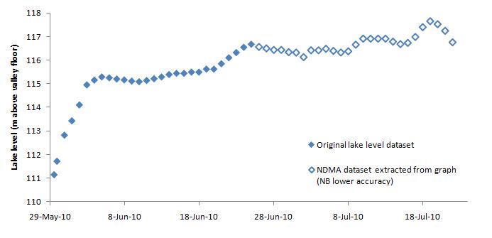
This is quite surprising. Assuming that the surface area of the lake is 1202 hectares (in fact it is probably a little larger in reality), this implies that about 5.8 million cubic metres of water has left the lake in the last 24 hours, representing a rate of about 67 cubic metres per second. However, the reported spillway discharge has not increased substantially – discharge at Ganish Bridge was 20,800 cubic feet per second yesterday and 20,837 cubic feet per second today.
So what is going on? Well it could be a measurement error, perhaps of the discharge. Alternatively it could be that the inflow has dramatically reduced, maybe because the weather has cooled.
Either way it is a surprising observation.
Finally, I somehow missed until today this low resolution image published in the Pamir Times a few days ago of the dam:
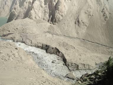
I am astonished at how much downstream erosion there has been since I last saw an image of the site.
Comments and thoughts welcome please.
 Dave Petley is the Vice-Chancellor of the University of Hull in the United Kingdom. His blog provides commentary and analysis of landslide events occurring worldwide, including the landslides themselves, latest research, and conferences and meetings.
Hmm…maybe there is a blockage upstream in the river – less inflow? Just speculation! Thank you for keeping us informed and doing such a great job in putting the various jigsaw pieces – however incomplete – togehter to make sense. That is a blessing!
A highly tantalising photo. Yes, there's downstream erosion, but there's next to nothing visible in the upstream portion; so, left in dark.The only thing that can be said is that the upstream portion seems to be changing very little compared to downstream.George
Could the water have gotten high enough, or heavy enough, to find another exit? Another valley, a cavern, a sinkhole? Keep in mind that I am a complete novice, know nothing about the terrain, and am just brainstorming here. In fact, if you know of a book about fluid dynamics for non-engineers or even children, I have been looking for one.Your blogs are fascinating, and I have learned a great deal from them. Besides landslides, they have increased my awareness of other cultures. I literally knew more about Saturn's moons than I did about Pakistan, before this. Thank you for sharing your knowledge, and please keep writing.
It's always interesting to read your blog but the numbers seem a little specious: flow rates to five significant figures, lake areas to four?However, if you take two significant figures for all concerned then the extra 67 cubic m/s is around 2300 cubic ft/s ie, over ten percent of the nominal outflow. That should be obvious to two significant figures of measurement.Can you enlighten us on how, if I stand at the side of a raging torrent or the side of a gentle stream I measure the flow rate? I can throw a poo stick in and time it over a distance at that point in the flow (slower at the edges), I can measure the width but I can't see the depth. How does it work?
Dr. Dave- Like you, I've had a few things going on, but I am always happy to comment on these environmental risk issues. Once again, thanks for the forum.(Also remember it's now tropical storm season, and I follow those quite closely.)As far as the lateral erosion, that's probably from the increased flow rate. From the low resolution photo that I have not compared to earlier photos, it appears (once again, from my limited memory, with other things going on in my life) that the erosion is almost all lateral. There is probably some downward erosion, but it does appear mostly lateral. This is interesting in that the base appears to remain solid, even as the spillway widens.Now onward to "anonymous" at 11:08 July 22."It's always interesting to read your blog but the numbers seem a little specious: flow rates to five significant figures, lake areas to four?"This is not unusual. Back before the over-topping of the dam, there was nearly zero flow, even though the lake was a hundred feet deep. It would be easy to measure nearly zero flow with greater precision than the surface area of the lake. Also the surface area of the lake is going to be very difficult to measure, given all the valleys, and other geographical features of the area.Now onward to flow measurement-"Can you enlighten us on how, if I stand at the side of a raging torrent or the side of a gentle stream I measure the flow rate? I can throw a poo stick in and time it over a distance at that point in the flow (slower at the edges), I can measure the width but I can't see the depth. How does it work?"I have no idea the specific methodology that's being used, but let's start with the basic idea that just because you cannot see the bottom that does not mean that it is unknown. The Hunza is a river that has great swings in flow, and during the winter months the flow is minimal. The river bed could be surveyed, especially during the low-flow period.Once we have the cross sectional area, all we need is the average speed that the water is traveling, and we're home free for volume of flow.Once last comment: Depth can be measured even when it cannot be seen.
I wish there were a set of photos from that downstream observation post to document the change over time. It would appear that the censorship initiative has worked.Pakistani Met's hydrographs show a four or five day increased flow at Partab Bridge. It has been falling for 2 days now. Cooler weather could be the probable reason.combined hydrograph for the IndusNote the falling away from peaks at both Besham and Tarbella. (They are the downstream catchments below Partab Bridge.(About the brown line peak: Chashma is in medium flood as per their flood advisory page A.)hydro graph index pageand their flood index page
Temperature in northern Pakistan has dropped by 15-20 Degrees Celsius in past days and is consistently low.
Dave,Is it possible that the lake has deepened at the bottom surface. We know that water speed at the bottom is sometimes more than at the top.
Sorry for my bad english, i hope you understand what i mean.I am a master of waterway building from germany. The water speed in a body of water is the biggest in second upper quarter. On top and below the friction brakes the speed. But by a lake of over 100 m deth und this dimension you have in the sea not measurably speed. differently in the spillway. I have for the different water level the following opinion: Is there information to the wind force and direction in the last time? By the length and the dimension of the lake, wind can dam up the water these level lightly.Dave, you make a good job and i visit this site daily.Michael
Dear Dr.Dave,The decision of the government to drain the lake through blasting seems to have come at the least suitable of times when Inflow is about to reach its highest levels. Would u agree with the following steps:1)If chances of breach have not increased, then perhaps should let the situation continue till inflow starts to reduce. So let all of August pass.2) Guage the qty of water being discharged through seepage(please specify if you know). If seepage has increased over time than perhaps seepage outflow will continue at this level throughout the life of the lake.3)September might see constant outflow and significantly reduced inflows thus noticeable reduction in lake levels will start.4)Once lake level goes below spillway floor height, then seepage will be the only means of outflow. At this point spillway can either be makde bigger, through earth moving equipment or controlled blasts or both.5)If seepage in September/October is higher than inflow, the problem is resolved in that lake will drain gradually going into the winters.Thus is it correct to say that if seepage is in the range of 5000 cusecs plus, lake will drain itself by winters or drain to a point where blasting and subsequent breach will not cause any damage downstream?
The lake level is significantly dropping, but the outflow is not going up as drastically. The latest NDMA report, July 23, reports a 28 inch drop since 0900 hours on July 22, but the discharge at Ganish Bridge is 19,280 cusecs."Anonymous said… Temperature in northern Pakistan has dropped by 15-20 Degrees Celsius in past days and is consistently low. 6:02 AM, July 23, 2010"The much cooler weather would greatly reduce inflow into the lake, given this is a river that relies so heavily on glacial runoff.Also given that we are very near the peak flow, and within the band of the peak flow time, according to the report posted here, the peak flow may have already been realized. Given how temperature transfers, I suspect that the weather may not warm up enough to increase the lake level beyond the ~20 feet above the initial (May 29) spillway. Even if there is an increase in flow, the 20 feet allows for some variance. Today the lake is about 15 feet above the initial spillway, so to go above 20 feet, the increase would need to be more than 5 feet in lake height, and the current direction of the lake depth is lower.I cannot rule out the possibility of a heat wave going through the area in the near future, but I suspect that it will not be enough at this late stage.