27 May 2010
Attabad: update for 27th May
Posted by Dave Petley
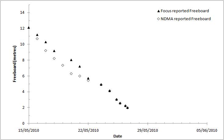
Filling of the lake behind the slide at Attabad continues, with the reported freeboard being 1.98 metres as of yesterday afternoon. I have not yet received a value for today – I will update the figures when this comes through. For now the freeboard time graph looks like this:
This would suggest a likely date of overtopping of 28th to 29th May, but once again caveats apply. It is now clear that the spillway floor is deforming, and in particular uplifting. This means that the rises in lake level are not automatically translating into a reduction of freeboard. There are two possible explanations for this uplifting behaviour. First, it could be that they clay is swelling as it becomes wet. Second, it is more likely that the clay is deforming due to the stockpile of excavated material on the sides (see my post yesterday) pushing down on the clay, and squeezing it out, much like a toothpaste tube.
Either way, the upshot is that the freeboard is a moving target. Through into the mix the ongoing failures on the flanks of the spillway, which could block the channel, and the overtopping date becomes more uncertain. Meanwhile the lake level continues to rise; estimates from satellite imagery suggest that the volume may have now exceeded 500 million cubic metres. This is three times the volume that the Chair of NDMA was quoted as saying in the Pamir Times yesterday That is a huge amount of water, most of which is likely to pass through the Hunza valley in the next few days. If a large flood does occur then the water will entrain debris from the dam and from the channel downstream, increasing its size. Thus, I maintain the view that the 60 metre level is the minimum safe height down to Tarbela, although I also note that this assumed that there was an effective spillway. Of course, if the flood induces slope failures on the banks then people at higher elevations could also be at risk. The reported available volume at Tarbela is much greater than this flood, however I have no means to validate this.
Finally, at a meeting I attended last night on disaster risk reduction there was a discussion about preparedness for disasters. The comment was made that as a crisis develops a government should prepare for the worst and hope for the best. This would seem to be a sensible approach at Attabad.


 Dave Petley is the Vice-Chancellor of the University of Hull in the United Kingdom. His blog provides commentary and analysis of landslide events occurring worldwide, including the landslides themselves, latest research, and conferences and meetings.
Keep up the good work Professor. May God bless you really for service to humanity, the people of Allah on this earth. Amin.
Is it confirmed (from gps or some other way) that spilway is actually rising? If it is not confirmed then there might be another explanation for slower filling rate, that is, the reservoir is V shaped (not U), and if inflow is constant then rising of level will not be uniform, because more volume of water would be required to fill each unit of height. So rising of level should be slower and slower day by day, specially when lake has become so many kilometers long, and becoming wider due to rising water level.
in my opinion, the height of waves will not exceed 15 meters above river bed due to 1. low degree of slop, (downstream slop)2. Banks of spillway will continue to collapse and again eaten by running water creating delay in outburst 3. from the pictures we can see there are huge boulders and rock that will sink while the soil around will be flooded and my gut feeling says thirty to forty percent of the existing lake will remain intact even after the outburst.