25 May 2010
Attabad – a bizarre race between two processes
Posted by Dave Petley
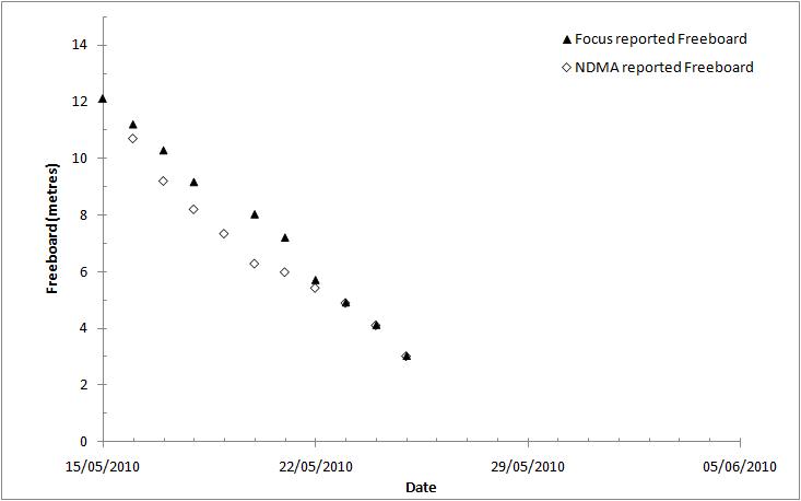
Yesterdays “coalition” resurvey of the spillway and water level now appears to provide a definitive freeboard value. As of 8 am this morning the freeboard was 3.027 metres, representing an increase of water level of 1.09 metres in the last 24 hours. This elevated rate of water level rise probably reflects the warmer weather in the area in the last few days, which will be driving snowmelt.
I have recalculated the freeboard values assuming that the official numbers released today are correct, meaning the the early figures under-estimated the true freeboard figure. The resulting graph is as follows:
At the current rate of increase the freeboard will be lost in two to three days, but as before we are reliant upon these figures being correct. This episode of incorrect freeboard measurement does not reflect well on NDMA, given the importance of these numbers. Of course, the fact that the saddle is located at a higher elevation means that the lake volume will be larger – i.e. it increases the size of the potential flood.
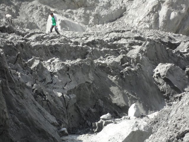
Of great concern to me though is the continued problem of closure of the spillway. It is clear that the banks of the spillway are failing in multiple locations. These failures are progressively closing the spillway, as this Focus image, taken of the spillway banks yesterday morning, shows:
The concern would be that the spillway closes completely before the water level reaches this level, which would effectively increase the freeboard once again, albeit probably briefly. In effect we are in a high stakes race between the rate of water level rise and the rate of closure of the spillway. The strength of the clay material forming the spillway banks is clearly low, as we believed from the start. Either way, the spillway is clearly completely incapable of handling the flow, so erosion is inevitable. The one bright spot is that the failed banks may erode preferentially, allowing the channel to widen more rapidly than it down-cuts, as happened at Tangjiashan.
Finally, lets not forget the hardship that this crisis is imposing on the local people. The Pamir Times today puiblished this image of a camp for Internally Displaced People (IDPs):
I need say no more.


 Dave Petley is the Vice-Chancellor of the University of Hull in the United Kingdom. His blog provides commentary and analysis of landslide events occurring worldwide, including the landslides themselves, latest research, and conferences and meetings.
Thanks for the update, Dave!Things out there, don't seem good at all.
Thansk for the picture of the local peorple's camp. I think in all the talk of freeboards and spillways we might lose sight of the real impact of all this, on the people. The photo ilustrates so graphically their current plight and what they stand to lose: their homes and fertile land below the rocky scree.
OMG even that camp looks tenuous!NDMA update for 25/5 is now available and states spillway "24 Meter deep and 45 Meter wide" completed by FWO on 15/5. I am not sure in which parallel universe that might be??Total affected persons now listed at 42,000
"Somehow the water level has decreased and it may take 5-6 days till the water start entering the spillway"…..so the latest news from atabad says.
There is some contradiction in info, 0n 24 May 10, the free board was 1.15 m while as of 25 May 10, free board is 3m, what I presumed that may the info given on 24 May 10 is incorrect or the info given on 25 May 10 is incorrect or the water level is reducing based on increase in seepage flow. Would you please comment.ThanxEngr. Farman KarimDubai
I just looked at this for the first time and I am interested in seeing more. I have always appreciated seeing pictures of a place of enormous beauty – people and geography. This seems like a situation man might not have any control over – at least the end effect.