
12 May 2010
New satellite image of the Attabad landslide, Pakistan
Posted by Dave Petley
NASA have released a new ASTER image of the lake that continues to build behind the landslide at Attabad in Hunza, N. Pakistan. Included in this image is the outline of the lake as it was in their image in March, showing the increase in surface area:
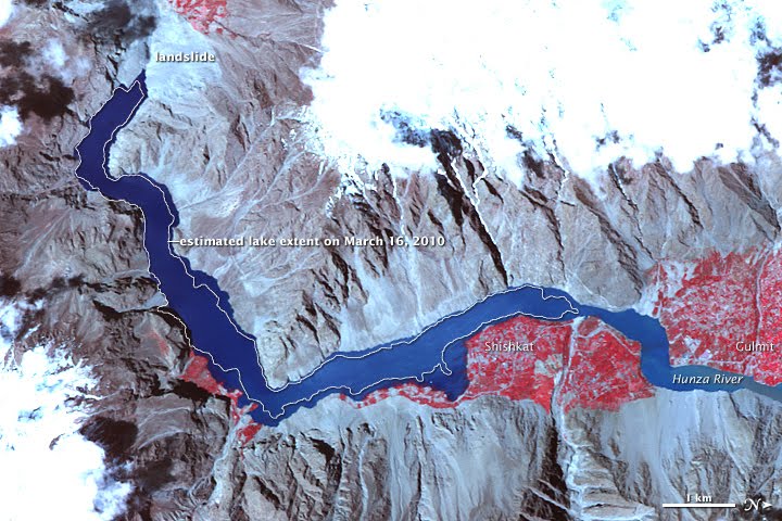
A couple of things to note on this image:
1. The red areas indicate vegetation. Given that this area is very close to being a high altitude desert, this indicates the location of cultivated areas. The image clearly illustrates the way in which cropland is now being inundated;
2. The cultivated area on the southern side of the image is Shiskat, which is built on a fan. The image dramatically shows how the recent growth of the extent of the lake has left this area completely isolated. If the lake were to last through the summer then this area is likely to face serious challenges next winter;
3. The danger posed by a further landslide into the lake creating a wave that could rapidly overtop the dam is dramatically illustrated here. There is no shortage of potentially unstable slopes. This is a source of very real worry to me now.
Meanwhile, the seepage rate continues to increase as the lake fills, and a new seepage point emerged yesterday. The graph of measured seepage against time shows the continuing increasing trend:
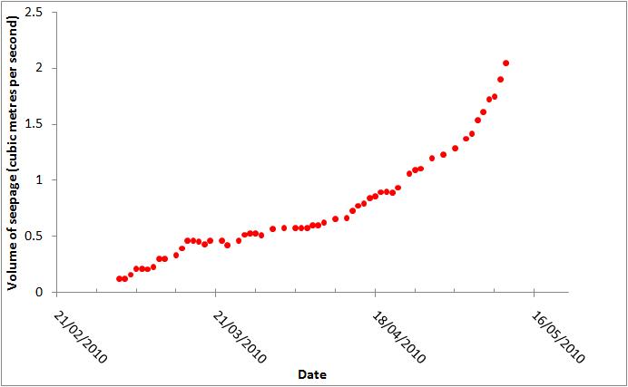
Whilst the seepage is not yet at worrying levels, the rate of internal erosion from this water flow could increase rapidly as the flow rate rises. Therefore, we need to continue to be mindful of the threat that this seepage potentially poses, especially in the last few days. We cannot rule out the possibility of a piping-induced failure.
The rate of increase of water level has slowed a little over the last few days, probably because the surface area of the lake has dramatically increased. Based on current rate of filling this has pushed the estimated date of water flow through the spillway back a little to 25th-28th May. This may well come forward again if the rate of inflow into the lake increases, which is what we would expect at this time of year. As of yesterday, the freeboard was just 12 metres, with the rate of rise of the water level being about 80 cm per day. Downward excavation of the spillway has now apparently ceased at a total depth of 14 metres (against the planned 30 m); the focus is now on widening the channel. As far as I am aware there is no armouring of the structure to prevent erosion.
I will update the monitoring site later today.
 Dave Petley is the Vice-Chancellor of the University of Hull in the United Kingdom. His blog provides commentary and analysis of landslide events occurring worldwide, including the landslides themselves, latest research, and conferences and meetings.
thanks David for your contribution on the developments in attabad and gojal region of remote pakistani am wondering about the current situation of the region when water has to be released and if there is any specific updates on it thanks
I am surprised its only the Army which is in the forefront in creating a spillway and dealing with the technical aspects. Are there no experts in Pakistan, I believe there is a complete Water and Power Development Authority which has experts in such matters? Are they purposely silent to save their reputations in case of a Dam Burst?One is forced to believe that in Pakistan Only the Army is competent enough to manage the country, on all matters whether technical or Administrative.David thank you for your concern and your efforts,we have a dearth of people like you and wish you had been in Pakistan to at least educate the experts to take on their responsibilities.
Unfortunately thats the tragedy of pakistan.. no other institution has been allowed to grow. I wont be surpised if the Water Dev Authority is also headed by a retd Pak Army General!! But i did not understand apart from providing the excavators what else is Pak Army doing? if its Pak Army , you can be sure it will be a shoddy job. Anyway, excellent site and feel so sorry for the village folks who inhabit the region. Dave, can you tell us what will be the long term effects of this flooding if any.