
19 January 2010
Landslides from the Haiti earthquake – not many!
Posted by Dave Petley
NASA has today released an image, partly obscured by cloud, of the upland area to the south of Port-au-Prince. This is the area that received the highest levels of shaking and, given the terrain, was most likely to have suffered slides. The image is available here:
http://photojournal.jpl.nasa.gov/catalog/PIA12495
and a comparison with an image taken in 2008 is here:
http://earthobservatory.nasa.gov/IOTD/view.php?id=42333
Note that this area suffered heavy rainfall in the 2008 hurricane season.
This is a close-up of a part of the area, close to, and just to the south of, the fault:
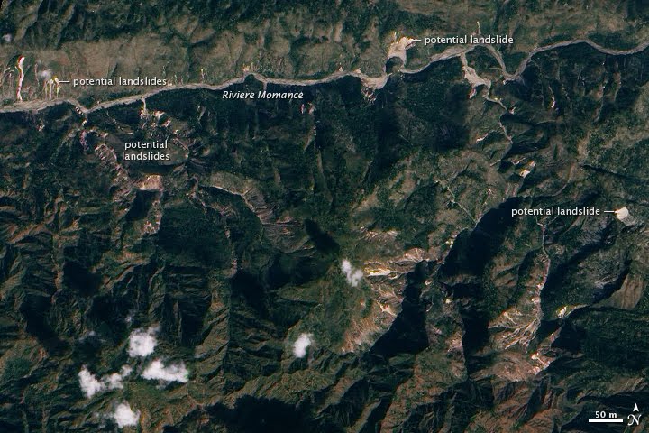 Clearly there are landslides visible, but the number is comparatively low and for the most part the slides are small. Note that NASA has, understandably, marked them as being “potential landslides”. The terminology used here might be interpreted as indicating the possible existance of a landslide, rather than an area in which a future landslide may occur. The big unknown is whether there is a higher likelihood of sliding in the next heavy rainfall event. This can only be addressed with fieldwork, but I am not sure who will do this (maybe the USGS?). It is also essential that refugee camps are located away from potential mudflow and debris flow tracks (the worse structure to be in during a debris flow is a tent – they offer no protection, but the ropes and pegs make rapid escape difficult). I hope that this will be taken into account as the situation stabilises.
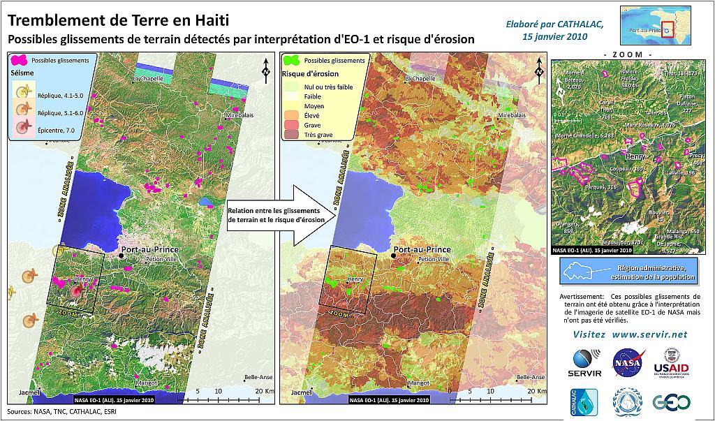
Finally, servir.net has produced an erosion potential map for the earthquake-affected area, which is available here:
 Dave Petley is the Vice-Chancellor of the University of Hull in the United Kingdom. His blog provides commentary and analysis of landslide events occurring worldwide, including the landslides themselves, latest research, and conferences and meetings.
Just wanted to be sure you and your readers are aware of GeoEye's free high resolution imagery available until 1-28-10. Available at:http://www.google.com/relief/haitiearthquake/geoeye.htmland the footprint file can be obtained:mw1.google.com/mw-earth-vectordb/haiti/Haiti-Earthquake-nl.kml
Dave:I am really not sure who's correct. On the one hand I've followed the work of Dr. Masters for many years. On the other hand, I have no reason to dispute any of your claims.Specifically, you claim:"Note that this area suffered heavy rainfall in the 2009 hurricane season."Relative to Haiti Dr. Masters, on the other hand, claims, "After making it through the hurricane season of 2009 without a scratch…"http://www.wunderground.com/blog/JeffMasters/comment.html?entrynum=1412"Dr. Masters co-founded the Weather Underground in 1995 while working on his Ph.D. He flew with the NOAA Hurricane Hunters from 1986-1990."Maybe Dr. Masters is talking about a different area of Haiti? There was extensive rainfall and damage in Haiti during the 2008 season. Maybe you're mixing 2009 and 2008 up? I don't really know."Up until the quake, the hurricane season of 2008 was the cruelest natural disaster ever experienced in Haiti."http://www.wunderground.com/blog/JeffMasters/comment.html?entrynum=1413I guess the ultimate question is when the storms passed relative to when the photo was taken. If the rains were after the photo was taken, then it's the 2008 Season.Here is a map of the 2009 season, and no tropical strength storms were that close to Haiti:http://www.wunderground.com/hurricane/at2009.aspThe 2008 season map is here:http://www.wunderground.com/hurricane/at2008.asp
TropicalIn fact both myself and Dr Masters are wrong:Me – yes, 2008 not 2009Dr Masters – the 2008 hurricanes were certainly not the cruelest naural disaster in Haiti's history. Hurricane Jeanne in 2004 was far worse for example (>3000 deaths in Gonaives). Dave
Actually it was the total impact, and not just deaths. Missing and injured are not deaths, so these are excluded from the death count. I am not about to compute the present value of any life–I'll leave that to actuaries. The 2008 storms brought a great deal of economic hardship.In 2008, "Four storms–Fay, Gustav, Hanna, and Ike–dumped heavy rains on the impoverished nation. The rugged hillsides, stripped bare of 98% of their forest cover thanks to deforestation, let flood waters rampage into large areas of the country. Particularly hard-hit was Gonaives, the fourth largest city. According to reliefweb.org, Haiti suffered 793 killed, with 310 missing and another 593 injured. The hurricanes destroyed 22,702 homes and damaged another 84,625. About 800,000 people were affected–8% of Haiti's total population. The flood wiped out 70% of Haiti's crops, resulting in dozens of deaths of children due to malnutrition in the months following the storms. Damage was estimated at over $1 billion, the costliest natural disaster in Haitian history. The damage amounted to over 5% of the country's $17 billion GDP, a staggering blow for a nation so poor."The deaths from malnutrition are tough to attribute to any one storm. The total suffering of parents is high too. The devastation from the direct financial cost of over 5% of Haiti's economy, a country that's already so poor.Dr. Masters did cover the other deadly hurricanes to hit Haiti, including Jeanne of 2004:"The year 2008 was only one of many years hurricane have brought untold misery to Haiti. Hurricane Jeanne of 2004 passed just north of the country as a tropical storm, dumping 13 inches of rains on the nation's northern mountains. The resulting floods killed over 3,000 people, mostly in the town of Gonaives. Jeanne ranks as the 12th deadliest hurricane of all time on the list of the 30 most deadly Atlantic hurricanes . Unfortunately for Haiti, its name appears several times on this list. Hurricane Flora killed over 8,000 people in 1963, making it the 6th most deadly hurricane ever. An unnamed 1935 storm killed over 2,000, and Hurricane Hazel killed over 1,000 in 1954. More recently, Hurricane Gordon killed over 1,000 Haitians in 1994, and in 1998, Hurricane Georges killed over 400 while destroying 80% of all the crops in the country."The deforestation is a major problem. Jeanne of 2004 probably would have resulted in few deaths if the trees were still present. Certainly the storm water runoff rates have drastically changed. The Dominican Republic took the direct hit of Jeanne, yet they survived much better.http://www.wunderground.com/hurricane/at200410.aspThere is little doubt, however, that the level of death and destruction of the 2010 earthquake will take years to heal from.I thank you for all the great coverage relative to the condition of Haiti's ports, landslides, and ground conditions. Long-term I really don't see how the country can survive without the ports, yet lifting those cranes out of the water is no small task. I can only imagine the damage from the saltwater.
Dear Professor Petley,I didn't receive your mail last 5-6 weeks. So I leave message here to make sure that you did receive my mail recently or there is something wrong with your academic mail address.Kuo-Lung
Earth Science posted a picture today showing mass wasting in Haiti some hours before the earthquake: http://epod.usra.edu/blog/2010/02/mass-wasting-in-haiti.htmlIt doesn't need an earthquake there to cause big landslides…