
4 October 2009
Emerging news of landslides triggered by the Sumatra earthquake
Posted by Dave Petley
It is interesting to note that in all three of the large earthquakes upon which I have worked (1999 Taiwan, 2005 Pakistan, 2008 China), the media has tended to initially focus their coverage upon urban areas, whilst the real story has actually been in the rural hinterland. The reasons for this are complex of course, and include the power of the imagery of people buried / being rescued from buildings. However, the main reason is of course that in upland rural areas landslides kill large numbers of people whilst also destroying communications links and power infrastructure. Thus, the disaster in these areas goes unreported for some time; even the government is often unaware of this situation. As I tell my students, in this case no news is definitely bad news – if no information is coming out about these upland rural areas then the situation is probably dire.
And so it has proven once again in the Sumatra earthquakes. It appears that yesterday communications infrastructure reached the point in which aid, and of course journalists, could start to get into the upland areas, whereupon it became clear that there has been a substantial disaster during this earthquake. AP have distributed this aerial overview shot, showing a series of large flow type failures in Padang Pariaman district:
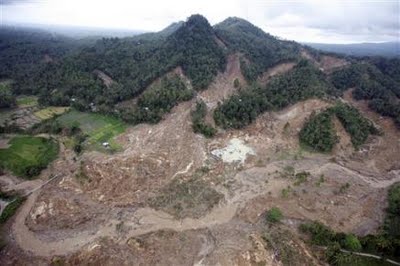 There are various reports about the impact of this landslide, which appears to have destroyed four hamlets: Pulau Aie, Lubuk Laweh, Cumanak and Gunung Tiga. Some reports suggest quite high fatality totals (>650 people). In this case local knowledge may be the most reliable, so I have taken a look at the Jakarta Post report, which says:
“Three hamlets have gone and 400 people are feared dead as the earthquake that shook West Sumatra on Wednesday produced a landslide that pushed the hamlets of Kapalo Koto, Cumanak and Lubuk Laweh into a river. An area of at least five square kilometers was buried by a huge landslide falling down from the nearby hills. A mosque which had stood 30 meters high disappeared with the hamlets. “
The higher death tolls being quoted elsewhere from this slide may be because the media are conflating estimates of the loss of life from all landslides with the losses from this single event. This is a Reuters quote from a Health Ministry Official:
“In the villages in Pariaman, we estimate about 600 people died,” said Rustam Pakaya, head of the Health Ministry’s crisis centre. Pariaman, closer to the epicentre, is one of the worst-affected.
In one of the villages, there’s a 20-metre-high minaret, it was completely buried, there’s nothing left, so I presume the whole village is buried by a 30-metre deep landslide.”
It is easy to read that quote as suggesting that 600 died in a single slide, but actually he is suggesting that this might be the loss “in the villages of Pariaman”.
The high loss of life in that particular landslide appears to be related to the fact that one of the villages was hosting a wedding party at the time of the landslide. There are a couple of other AP images of what is reported to be this landslide (although it could also be a different failure):

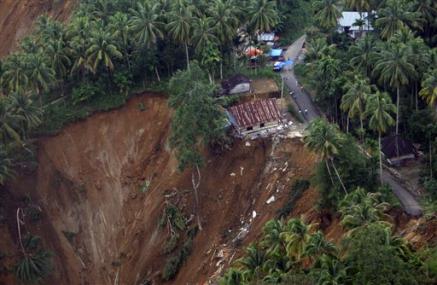
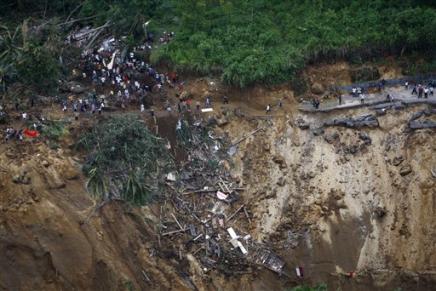 Unfortunately this landslide is certainly not the only one to have caused fatalities. The image below appears to show a different landslide (and note that in the background another failure can just be seen). Here it appears that a building has been incorporated into the slide:
 Meanwhile the BBC have a report here from another village affected by landslides, including a large failure in which the reporter suggests that ten people died.
Whilst the main concern at the moment must be the emergency response, a serious medium term worry will be that the rainy season for this area starts in November. Landslides will pose a very substantive hazard during that period.
 Dave Petley is the Vice-Chancellor of the University of Hull in the United Kingdom. His blog provides commentary and analysis of landslide events occurring worldwide, including the landslides themselves, latest research, and conferences and meetings.
Dave, Thanks for the information on this overlooked topic for the Sumatra earthquake – Thanks also for the photos –
wow..thank u so much for a good topic for me 2 do my current event on. i feel really bad for the people there..thank u for reporting this.its perfect.