
11 August 2009
Landslides from the Fiordland earthquake, New Zealand
Posted by Dave Petley
GNS Science in New Zealand have released details of the mapped landslide distribution from the Fiordland earthquake on 15th July. As I noted a day later, the number of landslides appears to be surprisingly low:
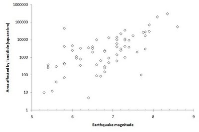
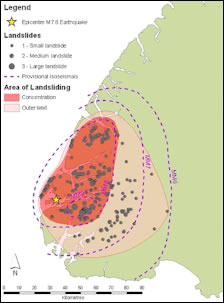 The earthquake produced only 187 landslides, most of which were shallow and comparatively small. The area affected by landslides was 5600 square kilometres. Comparison with the graph below (see my original posting) suggests that this is at the bottom end of the expected number for a Magnitude 7.8 earthquake.
According to Graham Hancox the reasons for this lower than expected level of landslides are thought to be:
1. The ground motions were smaller than would normally be expected for a magnitude 7.8 earthquake;
2. The dominant fault rupture motion was away from land;
3. Lower than average rainfall occurred in the two months prior to the 2009 quake.
The map suggests that there is a very strong relationship between the ground motion and the occurrence of landslides, with most of the mass movements being concentrated in the vicinity of the epicentre. This is consistent with, for example, the Chi-Chi earthquake in Taiwan.
 Dave Petley is the Vice-Chancellor of the University of Hull in the United Kingdom. His blog provides commentary and analysis of landslide events occurring worldwide, including the landslides themselves, latest research, and conferences and meetings.
thanks for a fascinating article.
Is the area heavily forested? Could ground cover be an important factor reducing the number of landslides?