
6 April 2009
A first take on the Italy earthquake
Posted by Dave Petley
You will probably be aware that an apparently quite destructive earthquake struck central Italy overnight. I thought I’d try to give a first take on the likely impact of this event. First, as ever, there is some pretty good information about the earthquake on the USGS Earthquake program website. They have provided the following helpful maps:
Earthquake location: Shaking intensity:
 Exposed population (PAGER):
At this point (c. 8:00 UT) the USGS is estimating that there are about 68,000 people living in areas that have suffered an earthquake intensity of VIII (severe shaking) or above, mostly in the town of L’Aquila. This is an area with a mix of old and new buildings built in a hilly area, as this image (from here) shows:
 Although the earthquake is not huge (USGS estimates are Mw=6.3), the shallow depth (10 km) and fairly vulnerable buildings means that the impact could be quite substantial, albeit in a fairly limited area. Italy is well-prepared for earthquake response, which will help.
So, what of landslides? Well, an earthquake of this size should be capable of triggering a fair number of slides. A good starting point is the Keefer (1984) relationship between earthquake magnitude and area affected by landslides:
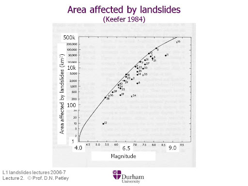 This gives an area affected by landslides as about 2000 km2 (give or take quite a lot, though). The area is certainly landslide prone, as this Google Earth perspective view shows (I have marked the epicentre location as per the USGS. The town in the foreground is L’Aquila):
 Incidentally, the mountain in the background is Gran Sasso, which houses an important particle physics laboratory in a deep tunnel. I would be interested to know how the experiments have fared during the earthquake.
 Dave Petley is the Vice-Chancellor of the University of Hull in the United Kingdom. His blog provides commentary and analysis of landslide events occurring worldwide, including the landslides themselves, latest research, and conferences and meetings.
Hi, Daves. I’m Paolo Cortopassi from Italy. I think you have been very fast to write about earthquake in L’Aquila, before many italian’s web.I find interesting the Keefer relationship (1984), but i have two questions:which are the limitations for this representation? Which kind of areas are put inside the relationship? Thank you. Paolo Cortopassi
Hi Dave.I conducted landslide research in Italy after the 1980 earthquake that killed around 2,750 people. In fact, that experience lead me to my PhD topic on determining the geomechanics of clay shales which affect large portions of Italy, as well as the US, Panama Canal, etc.(see summary or the complete dissertation .I agree with Paolo that the Keefer relationship has to be a bit oversimplified since the amount of landsliding should certainly be dependent on the underlying materials and of course geography. A figure used in my thesis illustrates how the underlying material affects landsliding in Italy.The area affected by the 1980 quake (NE of Naples) was within a similar area along the Appennini spine but was a little south of the current area (NE of Rome). The 1980 quake was in the zone underlain by clay shales where you see numerous historic landslide areas. The current quake area in further north and is primarily underlain by limestones with a less frequent history of landslides. I certainly wouldn’t say that there won’t be landslide and rock falls, but perhaps less slides than were experienced in 1980 (which were numerous and large).Thanks.Mike [email protected]
Dave and Paolo.The Keefer plot is interesting. It seems to me however, that the boundary that encapsulates the data points represents a maxima … that is, to the left of the line are conditions where landslides would be unlikely to occur. For example, one would not expect landslides 10 km from epicenter if the magnitude is only 6.0, but you MIGHT start to see landslides at magnitudes of 7.0 and higher, depending on the geographic and geological conditions.
The first point to note is that the data on Keefer’s graph (it comes from his classic 1984 paper) are from real earthquake events – i.e. what you see is data from actual earthquake events. Second, note that the y-axis scale is logarithmic, so if you take any particular earthquake magnitude you see a scatter of points over an order of magnitude or so. The line that Keefer drew is indeed the apparent upper boundary (as he noted in his paper). The scatter below this represents the effects of multiple processes. I am not sure that geology is the most important actually as I think that the landscape is adapted to the strength of the rocks (i.e. harder rocks will, all things being equal, form steeper slopes). Geology is important, but the key factors for me are the depth of the earthquake, the configuration of the fault(s) that ruptured and the groundwater state at the time of the earthquake. Geology controls the type of failure for sure as well as the distribution of landslides to a certain extent.Finally, it should also be noted that Rodriguez et al (1999) repeated Keefer’s work using earthquakes for the period 1980-1997. They concluded that “Generally the results are very similar, though the presence of extreme outliers in some of the correlations emphasises the need to be aware of special cases, particularly those involving quick clay landslides.” However, the graph between landslide area and earthquake magnitude was slightly amended – in fact they found that the upper boundary of the area of landsliding for any given magnitude was a little to the left / higher than Keefer found (i.e. they found landslide areas greater than Keefer’s upper boundary line indicated). They also noted a greater scatter below the upper boundary as well, but this would be expected given that they included earthquakes in coastal areas.
I didn’t predict the earthquake BUT I did 100% correctly predict The Pope’s response (@ YouTube), see…..http://www.youtube.com/watch?v=_m6qC6FCiY0
Dave.That makes sense. You’re saying that since slopes tend to be right at their critical state for stability, the slope of the terrain and the underlying material are for the most part already accounted for However, you still have to think that if a given area is more susceptible to landslides when there are no earthquakes, that perhaps it would also be more susceptible if there were earthquakes. Has anyone plotted the same data as a ratio of the number of landslides during earthquakes over the average number of known landslides in the area?Certainly the ground water and soil moisture conditions at the time of the quake should be a fairly significant factor since that would affect the amount of hydrostatic pressure within rock joints and between granular particle during the compressive part of the seismic wave.Quickclays are truly an interesting phenomenon … the fluidity of the collapsed mix seems to inhibit toe from building up which wouuld temporarily stop further slope failure. The clay shales in Italy show that tendency somwhat, but nothing like the films I’ve seen from Finland or Norway (?) where the head slopes continue to collapse like dominoes for miles. Do you know of any online videos of that phenomenon … I know I saw an incredible film about 30 years ago.Thanks.Mike Botts
Sadly, pictures of L’Aquila show that not only did old buildings collapse, but relatively new ones too- which begs the question: are the Italian building codes with regard to earthquake design adequate? Much has been made of the fact that Giampaolo Giuliani, a researcher at Italy’s Gran Sasso laboratory, alerted authorities in the region of Abruzzo that, based on radon levels, a quake was imminent – and was condemned for raising a false alarm. But Giuliani’s prediction- right or wrong- is really quite irrelevant- first, it isn’t possible yet to accurately predict the time and location of an earthquake; even Giuliani didn’t do that. But even if it was possible, the cost of reacting to the threat would be huge- every time radon levels rose, all businesses would have to shut down and people would have to be evacuated. If an earthquake then didn’t occur, the immense cost of lost business and evacuation would have to be covered- something that would soon be unpalatable if too many false alarms occurred. And if it did occur, you’d have to pay the cost of repairing all the collapsed buildings- something that would be inevitable if the area really is in an earthquake-prone zone. Given these realities, predicting earthquakes is far less important than ensuring that buildings are built, or retrofitted, to withstand expected earthquakes. So the real issue is: what is Italy doing to ensure that building- new and old- are able to withstand earthquakes? If a relatively small M6.3 earthquake wreaks the kind of destruction that it did in L’Aquila, then it really suggests that the building codes are woefully inadequate.
Hi,Dave, Mike and Frank. I would like to try to answer to Frank. In Italy it’s only from 2003 that all territory has been sismic classified in 4 classes. During the earthquake of Umbria e Marche in the 1998, Prof. Barberi had attempted to classify the territory unclassificated, just like San Giuliano di Puglia where 27 children were died inside the school (the only building that collapsed in that earthquake). The italian laws allowed, instead, to build with old laws yet and only, if you prefer, with new one. So we wait until 2003, but now in 2009 those laws are always in derogation, infact you can build with old laws. Only for public buildings, it will be necessary to design with new laws, but there are many and many others regulations that allow to use old laws yet. In Tuscany, where i lived, since 2003 the Region has began to give money for public buildings like schools and hospital, and some works has been well made. The application of 2003’s laws are the same in all regions, but it depend also by politics of every one. I hope you understand my poor english. Bye. Paolo Cortopassi
In southwest British Columbia, Canada, where I live, it took many years to recognize that we are living above a subduction zone where very large earthquake with return periods of several hundred years are possible. This has led to a continuing effort to not only upgrade building codes, but also to retrofit old buildings. We now must design for an earthquake with a 2% in 50 year probability of exceedence. Initially, some asked “how can we afford to build and retrofit to such a standard?” Now when we hear of sad events such as the earthquake at L’Aquila, we ask ourselves “How can we afford not to?”
Again, my experience with Italian earthquakes is 30 years old, but it sounds like from Paolo that perhaps things haven’t improved much.The building practices, particularly in southern Italy, greatly contribute to the number of deaths that can occur from earthquakes. Even many newly built homes often use the ancient practice of constructing walls with 1-2 foot round boulders, held in place with mortar and 2 thin stucco walls. These homes just become dead-traps when an earthquake simply reduces them to a large pile of large boulders with people trapped underneath. The fact that most cities in the interior of Italy are built on hills means that you have houses upon houses that collapse resulting in total destruction on the hillsides. Driving into some of these cities in 1980, I found it difficult at time to distinguish what was a collapsed city from what was a natural hill of rock.In 1980, we also found modern re-enforced concrete buildings fitted with rebar, in theory according to code, but where the rebar from the walls was never tied to the rebar in the ceilings. Thus, with the first shake, walls shift, ceiling collapses, then walls collapse from lack of ceiling support. Thus, building codes existed but were not followed or enforced.Finally, there were efforts after 1980 to re-enforce existing structures through the use of tie bars between walls and such, and perhaps some of these practices helped save lives in the 2009 quake (200+ dead versus 2700 dead +1500 still missing from the 1980 quake). The very said part is that many of these deaths could have been avoided with stricter legislation and stricter enforcement of building codes.I am curious how much things have changed.Thanks.Mike Botts
Hi Dave. Frank said on april 11, that in Canada (i think) they design for an earthquake with a 2% in 50 year probability of exceedence. The new italian laws of 2003 (i have said about in my answer), decided to design for an earthquake with a 10% in 50 year probabily of exceedence (Tr 475 year). What do you think about this? I don’t know how this problem is organized in USA and Japan. Can you help me? Thank you Paolo.