
8 June 2008
Updated@ Tangjiashan images deepen the mystery
Posted by Dave Petley
NB – I have now updated this with an image at the end that shows this more clearly.
A quick image search today showed up the following Reuters image, entitled: “Water from the Tangjiashan “quake lake” flows down in quake-hit Mianyang, Sichuan Province June 7, 2008. Chinese troops on Saturday eased pressure on a swelling “quake lake” threatening hundreds of thousands of people, but a smaller lake burst its banks in a show of destructive force.”
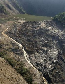 According to the caption this was taken on 7th June – i.e. yesterday.
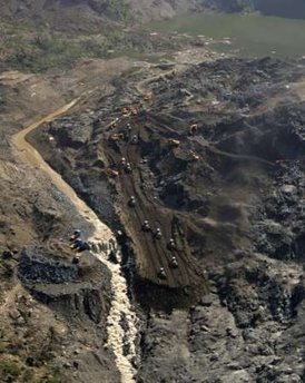
Now, lets compare this to the earlier image that we had by putting them side by side, with the older one on the left and the newer one on the right:
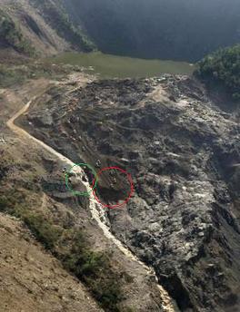
A few things to note here (see annotated image below):
1. There does appear to be more flow in the second image, though not vastly so;
2. The activities of the excavators in the second image appear to be to deposit soil and rock, not to be excavating it (highlighted with the red circle below). Are they filling something in here?
3. The small waterfall adjacent to the blue trucks in the first image has eroded back a considerable distance in the second one (highlighted with a green circle below). This shows that erosion is occurring, but through a nick point.
The timing of the image is crucial here. If it was indeed taken yesterday, and the nick point eroded back that far during the day, then the erosion back of this nick point becomes a very possible failure mechanism for the dam.
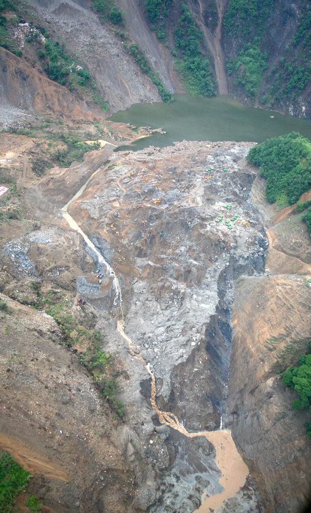
Updated – here is another Reuters image that shows this more clearly:
 Dave Petley is the Vice-Chancellor of the University of Hull in the United Kingdom. His blog provides commentary and analysis of landslide events occurring worldwide, including the landslides themselves, latest research, and conferences and meetings.
I think the bulldozers are building a second spillway. I dont seem to have enough detail to see the nick point.JJ
JJI have added another image to the post that shows this more clearly. It is plain to see both elements now I think.Dave
Water level and Flow:The water level rises to 742.58m (8th June, 8:00 am, Beijing time). Increase in water depth is about 0.92 meter in 24 hours. The daily average inflow is about 115cumec where as outflow from drainage and seepage from dam is about 25cumec.
Sorry for wrong date in previous comment:The water level of 742.58m is on 9th June, 8:00 am, Beijing time.
(http://news.xinhuanet.com/english/2008-06/09/content_8329997.htm)Strong aftershock felt on dam of China’s main quake lake:MIANYANG, Sichuan, June 9 (Xinhua) — A strong aftershock was felt on the dam of the Tangjiashan “quake lake” at around 11:04 a.m. Monday, a Xinhua reporter at the site said. The tremor sent rocks rolling down the surrounding mountains and splashing into the quake-formed Tangjiashan Lake in Mianyang City, one of the hardest-hit areas in the May 12 earthquake. The earthquake administration has not defined the magnitude of the aftershock and its impact on the dam is under surveillance. ………………… More than 100 soldiers of the hydropower force of the armed police, apparently used to the innumerable aftershocks, continued digging for a new spillway at the bottom of the lake’s dam. The new spillway would hopefully be connected with a drainage channel that has been operating since Saturday morning to accelerate drainage of the quake lake. Although Monday’s aftershock was clearly felt by everyone on the dam, it did not seem as powerful as Sunday’s 4.8-magnitude aftershock that caused massive landslides on the mountains surrounding the Tangjiashan lake. …………… China is still on the alert as the water level in Tangjiashan Lake reached 742.58 meters above sea level as of 8 a.m. Monday, a rise of 0.92 meters in 24 hours. Military engineers have fired short-range missiles to blast boulders in the channel to accelerate drainage. By Monday noon, the drainage speeded up to 50 cubic meters per second, but still far slower than the average influx of 115 cubic meters per second.