
17 May 2008
Satellite imagery of the landslides in the Sichuan earthquake
Posted by Dave Petley
Now that there is a brief weather window, satellite imagery is starting to emerge of the Sichuan Earthquake zone. At present most of these images are too low resolution to allow detection of the real damage to the buildings (which is notoriously difficult to achieve), but they are excellent for looking at landslides.
The best to date that I have seen has come from the Taiwanese Formosat-2 instrument, which is a moderately high resolution imaging system that passes over Taiwan (and thus China) on a twice daily basis (10 am and 10 pm). They have helpfully released before and after images of the Beichuan area:
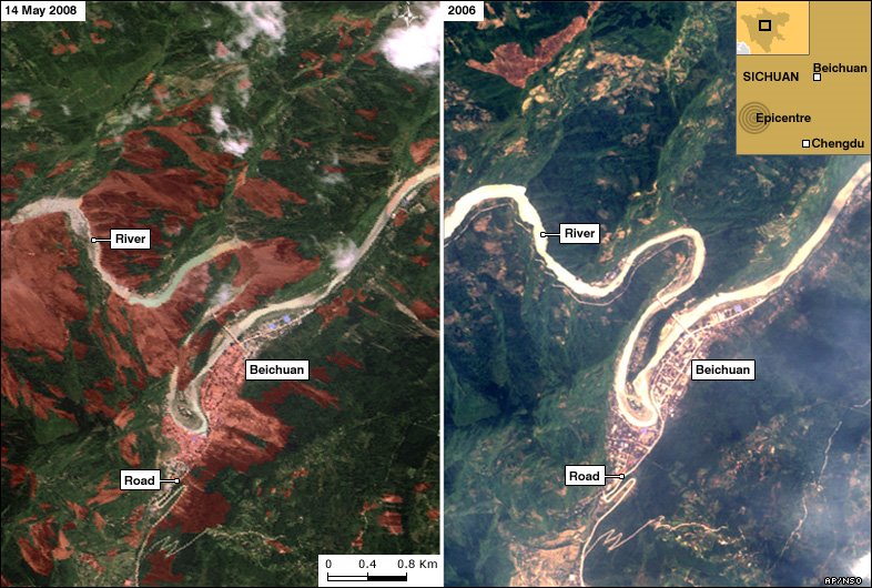 (Annoted from the BBC – click for a better resolution version)
The town in the centre of the image located around the river is Beichuan. The landslides are the brown areas on the left hand image – it is clear from this that about 20% of the land mass in this area has slipped. The southern edge of the town has been hit by a big landslide (see here) that appears from this image to have spread over a large area. Worryingly, some of the rivers also appear to have been blocked in two locations by landslides. I hope that urgent works are underway to resolve this as there is a real danger of a secondary disaster when the blockages are breached. This is an absolute crisis that needs very urgent action.
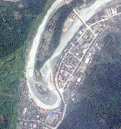
The Formosat-2 image has also been enlarged for Beichuan, again in before and after format. This is available here. This the before image:
 This is the after image annotated to show the big landslide:
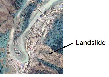 Note that the river appears to be blocked in this image too. There is no evidence of flow. Note also that the location of the very damaging landslide does not appear exceptional in the “before” image – this is a forested slope that looks the same as the surrounding slopes.
Finally, there are now ALOS images (both optical and radar) available. Radar adds little as the data are very difficult to interpret without processing. The optical image is better, and indeed has been annotated to indicate the location of landslides. To my eye there are many landslides that have not been annotated. Unfortunately the resolution is too low to be really helpful in this form. This is the image (click for a bigger view – warning this is a big file):

 Dave Petley is the Vice-Chancellor of the University of Hull in the United Kingdom. His blog provides commentary and analysis of landslide events occurring worldwide, including the landslides themselves, latest research, and conferences and meetings.