June 21, 2023
Rodman Glacier, Alaska Retreat Expands Lake Ustay
Posted by Mauri Pelto
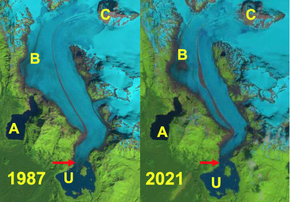
Rodman Glacier in Landsat images from 1987 to 2021 indicating 1987 terminus=red arrow, A=Akwe Lake, U=Ustay Lake, B=glacier base exposed, C=expanding nunatak
Rodman Glacier flows south from the Brabazon Range ending in Ustay Lake at the margin of the Yakutat Foreland. In the 1906 International Boundary Commission survey of the region Ustay Lake does not yet exist, Akwe Lake has just started to form with the terminus ending in it named Chamberlain Glacier. Chamberlain Glacier was a distributary terminus from Rodman Glacier and by 1948, the thinning Rodman Glacier no longer generated this second terminus. In the 1950’s the glacier terminated on an island in Ustay Lake. By 1968 Austin Post indicated that it had retreated 1400 to 2000 m from its maxiuum Little Ice Age position, but was still grounded on the island.
In 1987 the glacier had retreated 200 m from the island. In 2021 the glacier had retreated 800 m from the island. A slow retreat compared to nearby Yakutat Glacier, 21 km since 1906 and 10+ km since 1987) or East Novatak Glacier (2.75 km snce 1987). By Sept. 2022 the glacier had developed a 1 km long 0.4 km² terminus tongue that has significant rifts and will break up in the next year or two. This condition persists into June 2023. The glacier has also developed a significant area of 1.25 km² around Point B where bedrock is exposed in Sept. 2022 and an occasional glacial lake forms filling part of the basin such as in June 2023. At Point C an expanding nunatak indicates extensive thinning up to 800-900 m on this glacier.
Rodman Glacier in Sept. 2022 and June 2023 Sentinel Images indicating the terminus tongue with open water on both sides that is poised to breakup, yellow arrows. At Point B is an expanding area of bedrock in Sept. 2022 that is partially water filled in June 2023.
Rodman Glacier in 1950’s topographic map no Island yet in Ustay Lake.


 Dean of Academic Affairs at Nichols College and Professor of Environmental Science at Nichols College in Massachusetts since 1989. Glaciologist directing the North Cascade Glacier Climate Project since 1984. This project monitors the mass balance and behavior of more glaciers than any other in North America.