
June 8, 2023
Terra Nivea Ice Cap Expanding Bedrock Outcrops and Proglacial Lakes
Posted by Mauri Pelto
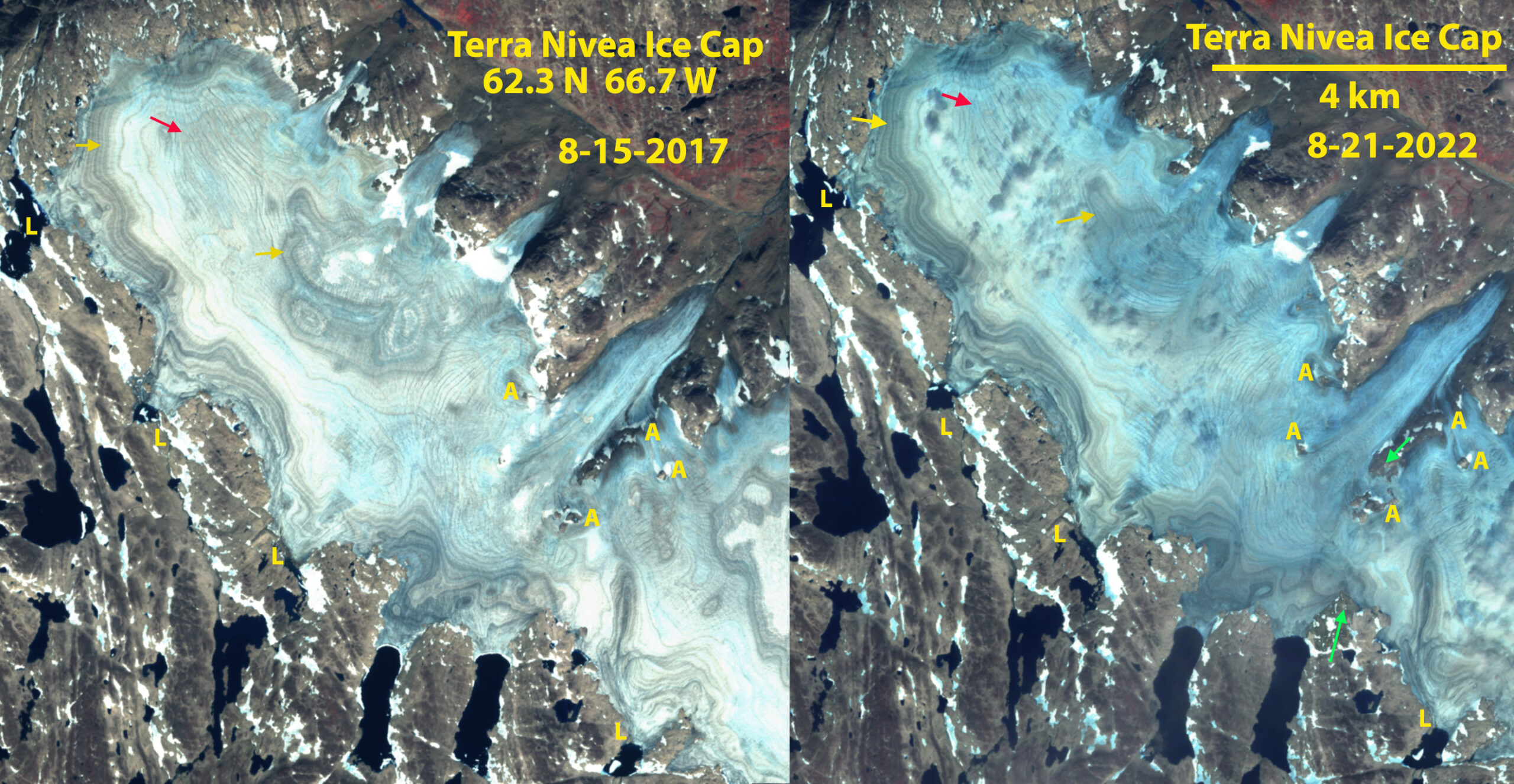
Terra Nivea Ice Cap in Sentinel false color images from 2017 and 2022. Point A=bedrock outcrops expanding. Point L=expanding proglacial lakes. Red arrow=supraglacial stream chanels, yellow arrow=annual layers, green arrow=location where ice cap will separate.
Terra Nivea Ice Cap is the southern most Ice Cap in North America, on the Terra Incognita Peninsula of Baffin Island. Mercer (1956) noted that the ice cap accumulation during most years was via superimposed ice, though some years snow did endure at the top of the ice cap. Paspodoro et al (2015) observed a 34% reduction in ice cap area from 1958-2014 with an acceleration after 2007. Here we note a lack of retained snow, firn or superimposed ice on the northern portion of the ice cap in 2017 and 2022. The lack of retained accumulation as snow or ice results in rapid thinning that is leading to bedrock expansion within and at the margin of the ice cap and the expansion of peripheral proglacial lakes.
Point A marks specific locations where bedrock areas amidst the ice cap are expanding. This expansion will lead to separation of the ice cap at the green arrows soon. The ice cap was 1.9 km wide at this point in 2017 and 1.5 km in 2022. Point L marks locatsions of proglacial lake expansion. The yellow arrows indicate annual layers even at the summit area, which would not be visible if superimposed ice was forming. The red arrows indicate supraglacial stream channel that lead all the way to the summit region. For an ice cap retaiining firn or superimposed ice, the channels would begin below that margin. This illustrates that during the the 2017-2022 there was no retained accumulation on Terra Nivea Ice Cap. This is true of the rest of the ice cap as well. Here in order to better visualize change, the focus is just on the northern portion.
This same story is playing out on Grinnell Ice Cap.

Terra Nivea Ice Cap in Sentinel false color images from 2017 and 2022 illustraing separation region. Point A=bedrock outcrops expanding. Point L=expanding proglacial lakes. Green arrow=location where ice cap will separate.
 Dean of Academic Affairs at Nichols College and Professor of Environmental Science at Nichols College in Massachusetts since 1989. Glaciologist directing the North Cascade Glacier Climate Project since 1984. This project monitors the mass balance and behavior of more glaciers than any other in North America.