
September 14, 2018
Yakutat Glacier Terminus Collapse Nears Completion, 45 km2 lost 2010-2018
Posted by Mauri Pelto

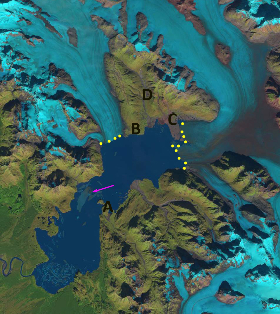
Landsat images from 2010 and 2018 with terminus indicated by yellow dots in both, the orange dots indicate 2010 margin on 2018 image. Point A indicates the 1987 terminus location, pink arrows indicate icebergs. Main terminus now extends south near Point C. Northern terminus extends west from Point B.
Yakutat Glacier, Alaska has experienced a spectacular retreat in the last decade losing 45 km² from 2010-2018. The Yakutat Glacier during the 1894-1895 Alaskan Boundary Survey ended near a terminal moraine on a flat coastal outwash plain. By 1906 the glacier had retreated from the moraine and a new lake was forming, Harlequin Lake. From 1906-1948 the glacier retreated an additional 5 km. From 1948-1958 the glacier retreated 3.6 km. Here we examine Landsat imagery to quantify the retreat from 2010-2018. This is an update to a Yakutat Glacier 2016 post
In 2010 the glacier has just retreated from the peninsula at Point A, the valley at D was deglaciated, a small strip of bedrock-sediment was exposed at C from that had been beneath the glacier, and B was still well inland of the terminus. An aerial image of the glacier indicates significant rifting, blue arrows, in 2010 that leads to the substantial 2013 breakup. Rifts are not just crevasses, as they typically extend to the base of the glacier along part of the glacier. They typically form in areas of a glacier that are near flotation. In this case an area that has thinned until approximate flotation (Benn, Warren ann Mottram, 2007). In 2013 there is a large area of icebergs and melange in front of the terminus, yellow dots. By 2013 the northern arm of the glacier had retreated 6.4 km from the peninsula at A toward the peninsula at B. The central arm of the glacier toward C had retreated 7.5 km and the retreat on the southern edge of the glacier was 6.5 km. In 2015 the snowline is quite high at 2200 m, leaving very little of the glacier in the accumulation zone. In 2015 a large iceberg detached pink arrow, that is 5 km by ~1 km. In 2016 the snowline is again around 2200 m. From 2013 to 2016 the glacier retreated from Point B to Point C on the northern side and to Point E on the southern side this is a distance of 10.2 km in thirty years since 1987 or 340 m/year. In 2016 the Peninsula extending across the lake from Point C is 2.5 km long. The terminus is resting on this and adjacent shoals across 50% of its width. The iceberg has diminished to 2.5 km long and 700 m wide, pink arrow. The northern terminus extending west from Point B has changed little from 2013-2016. The 2018 image compares the 2010 position (yellow dots) with 2018 (orange dots), indicating an area of 45 km² lost. The main terminus retreated 7 km. There are some small icebergs in 2018. The ability to produce icebergs as large as in 2015 has been lost as the calving front has been restricted by the Peninsula which is now 3 km long, leaving less than a 3 km wide calving front. The narrower calving front and reduced water depth should in the short term reduce retreat. The northern terminus near Point B has experienced limited retreat since 2013.
The glacier has thinned by more 200 m on average according to the preliminary thickness change maps from a U. Alaska-Fairbanks project (Truessel et al 2013) and updated by Truessel et al (2015). The Yakutat Glacier does not have a high accumulation zone and the recent increase in the snowline elevation and thinning of the glacier have led to a substantial shrinking of the accumulation zone and thinning of the glacier in the accumulation (Truessel et al 2013). This glacier does not have a persistent significant accumulation zone in 2015, 2016 and 2018 and cannot survive (Pelto, 2010). Truessel et al (2015) modelling indicates a reduced rate of retreat from 2020-2030, which supports the expected reduced calving. Their model also indicates the glacier will disappear between 2070 and 2110 depending on the warming scenario. For a calving glacier to be in equilibrium it needs to have more than 60 % of its area snowcovered at the end of the summer, this was not achieved in 2015, 2016 or 2018.. The glacier is in the midst of a large ongoing retreat. The retreat rate and calving mechanism is similar to that of Grand Plateau Glacier, Alsek Glacier and Gilkey Glacier. However, unlike these Yakutat Glacier lacks an accumulation zone, a better analog is East Novatak Glacier, which also has a lower elevation accumulation zone.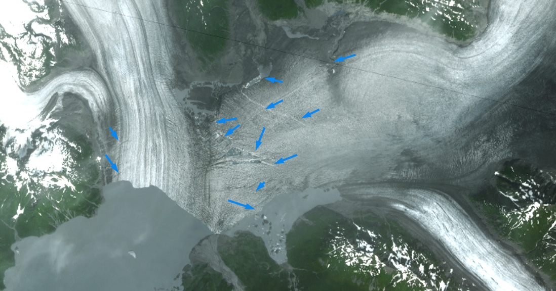
2010 image of the Yakutat Glacier terminus reach with blue arrows indicating rifts.

Landsat images from 2013 with terminus indicated by yellow dots. Point A indicates the 1987 terminus location. Note large area of melange and icebergs.

Landsat images from 2015 with terminus indicated by yellow dots. Point A indicates the 1987 terminus location. Main terminus now extends south near Point C. Northern terminus extends west from Point B. Note large iceberg that calved in 2015, pink arrow.
Landsat images from 2016 with terminus indicated by yellow dots. Point A indicates the 1987 terminus location. Main terminus now extends south near Point C. Northern terminus extends west from Point B.Note large iceberg that calved in 2015, pink arrow.
 Dean of Academic Affairs at Nichols College and Professor of Environmental Science at Nichols College in Massachusetts since 1989. Glaciologist directing the North Cascade Glacier Climate Project since 1984. This project monitors the mass balance and behavior of more glaciers than any other in North America.