
December 4, 2018
San Quintin Glacier High Calving Rate Observations in 2018
Posted by Mauri Pelto
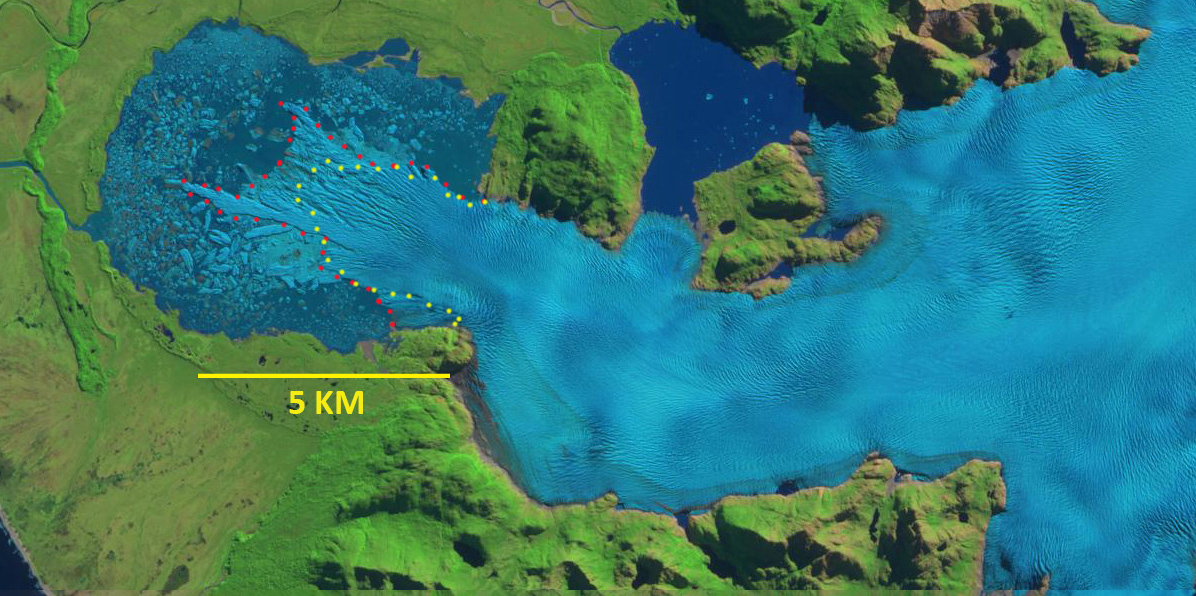
San Quintin Glacier in 4-16-2017 Sentinel image, red dots indicate terminus location then. Yellow dots the terminus location on 11-10-2018.

San Quintin Glacier in 3-20-2018 Sentinel image, pink dots indicate terminus position.
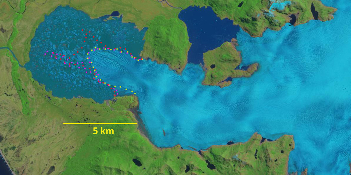
San Quintin Glacier in 11-10-2018 Sentinel image. Yellow dots the terminus location on 11-10-2018, pink dots from 3-30-2018 and red dots from 4-16-2017.
San Quintin is the largest glacier of the NPI at 790 km2 in . The glacier extends 50 km from the ice divide in the center of the ice cap. The peak velocity is 1100 m/year near the ELA (Rivera et al 2007), declining below 350 m/year in the terminus region. San Quintin Glacier terminated largely on land until 1991 (Davies and Glasser, 2012). The velocity at the terminus has increased from 1987 to 2014 as the glacier has retreated into the proglacial lake (Mouginot and Rignot, 2015). The high velocity zone extends more than 40 km inland an even greater distance than at San Rafael (Mouginot and Rignot, 2015). Thinning rates in the ablation zone of the glacier are 2.3 m/year (Willis et al, 2012). The glacier has a low slope rising 700 m in the first 22 km.
In 1987 it is a piedmont lobe with evident minimal marginal proglacial lake development beginning (Pelto, 2016). Progressive retreat of the glacier into the expanding proglacial lake has led to an increasingly chaotic, disintegrating front of the glacier (Willis et al, 2012). The large evident crevasses/rifts perpendicular to the front suggest the terminus tongue is largely afloat. Here we examine Sentinel Images from April 2017 to November 2o18 to identify changes. NASA’s Earth Observatory has high resolution images indicating the terminus in June 2014 and April 2017
On April 16, 2017 there were four icebergs with an area greater than 0.1 km2 in the San Quintin Lagoon. The narrow terminus tongue extending from the main terminus had an area of 0.6 km2 and extended to within 3.3 km of the lagoons western shore. On March 20, 2018 this tongue remains tenuously connected to the main terminus, and has extended to within 1.5 km of the western shore. There are six icebergs with an area greater than 0.1 km2. By November 10, 2018 this narrow tongue had disintegrated. There are eight icebergs with an area greater than 0.1 km2. The icebergs are slow to melt in the lagoon compared to a fjord setting. The overall terminus area loss from April 2017 to November 2018 is 1.8 to 2.0 km2. There has been additional detachment on the southern shore where the glacier enters the main lagoon basin. This should further destabilize the glacier tongue. In the coming years the lagoon will continue to expand to a size of at least 40 square kilometers.
As Pelto (2017) noted 19 of the 24 main outlet glaciers of the Northern Patagonia Icefield ended in a lake in 2015, all the lake termini retreated significantly in part because of calving losses. Glasser et al (2016) observed that proglacial and ice-proximal lakes of NPI increased from 112 to 198 km2. A collapse of the terminus tongue on Steffen, Gualas and Reichert Glacier are examples.
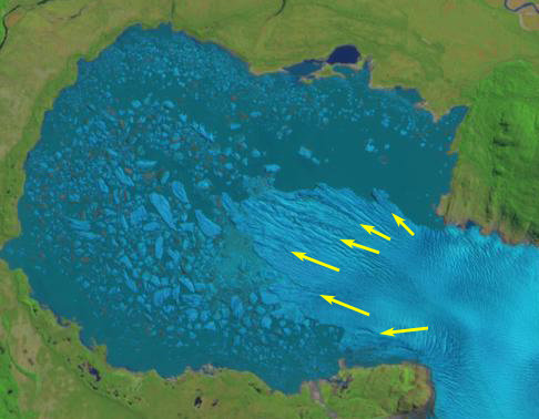
October 31, 2018 Sentinel image indicating extensive rifts that have developed and are areas of weakness for further calving.

Landsat comparison of San Quintin Glacier in 1987 and 2015: red arrow indicates 1987 terminus location, yellow arrow indicates 2015 terminus location of the three main termini, and the purple arrow indicates upglacier thinning.
 Dean of Academic Affairs at Nichols College and Professor of Environmental Science at Nichols College in Massachusetts since 1989. Glaciologist directing the North Cascade Glacier Climate Project since 1984. This project monitors the mass balance and behavior of more glaciers than any other in North America.