
June 5, 2018
Warm Creek Glaciers, British Columbia Retreat Driven Separation
Posted by Mauri Pelto

Warm Creek, (W) Norht Warm Creek (NW) and Bighorn (H) Glaciers in Northwest British Columbia in 1984 and 2017. Red arrows are the 1984 terminus location, yellow arrows the 2017 terminus locations and purple arrows where glaciers have separated.
In Northwestern British Columbia a group of unnamed glaciers drain into Tagish Lake via Warm Creek and Bighorn Creek. Here we examine the profound changes in three glaciers from 1984 to 2017 using Landsat imagery. These glaciers are in the northeast sector of the Juneau Icefield, sharing a divide with the retreating Meade Glacier, Alaska. The Juneau Icefield Research Program focuses on glaciers to the south of these including the retreating Llewellyn Glacier.
In 1984 Bighorn Glacier (B) has two termini joined at 1500 m, with the northern terminus ending in two small proglacial lakes and the southern terminus extending down valley to the red arrow. In 1984 Warm Creek Glacier terminates in a small proglacial lake, red arrow. The North Warm Creek Glacier (NW) has two tributaries joining at 1350 m, 1 km above the terminus. In 1999 the snowline is at 1650 m on these glaciers leaving only 20% of Bighorn Glacier above the snowline. North Warm Creek Glacier tributaries have separated due to glacier retreat. Retreat has led to proglacial lake expansion at Warm Creek Glacier. In 2001 it is apparent that the retreat of the northern terminus of Bighorn Glacier has led to expansion of the proglacial lake. The snowline is lower in this 2001 image at 1500 m. By 2017 Bighorn Glacier has separated with nearly 1 km of bedrock separating the northern and southern sections. The southern terminus has retreated 1100 m and the northern terminus 500 m. The Warm Creek Glacier retreat from 1984-2017 is 1300 m, more than doubling the length of the lake. The North Warm Creek Glacier tributaries are now well separated. Retreat of the northern terminus has been 1000 m and 1200 m for the southern terminus. The snowline in 2017 is again at 1700 m, too high to sustain these glaciers. The retreat of these glaciers fit the pattern of other glaciers in Northwest British Columbia such as Llewellyn, Tulsequah and West Hoboe Glacier. Bolch et al (2010) noted a 11% loss in glacier area in the province from 1985-2005 and an 8% loss in the Northern Coast Mountains.
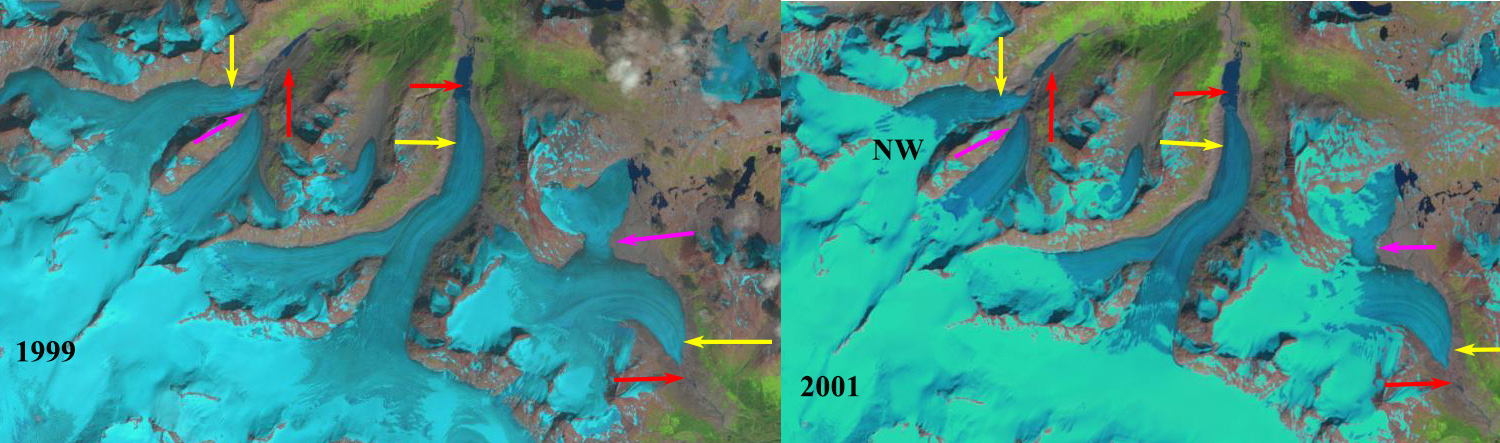
Warm Creek, (W) Norht Warm Creek (NW) and Bighorn (H) Glaciers in Northwest British Columbia in 1999 and 2001. Red arrows are the 1984 terminus location, yellow arrows the 2017 terminus locations and purple arrows where glaciers have separated.

Toporama Map of the region showing flow directions from the 1980s’
 Dean of Academic Affairs at Nichols College and Professor of Environmental Science at Nichols College in Massachusetts since 1989. Glaciologist directing the North Cascade Glacier Climate Project since 1984. This project monitors the mass balance and behavior of more glaciers than any other in North America.