
May 4, 2018
Tulsequah Glacier, British Columbia 2900 m retreat 1984-2017
Posted by Mauri Pelto
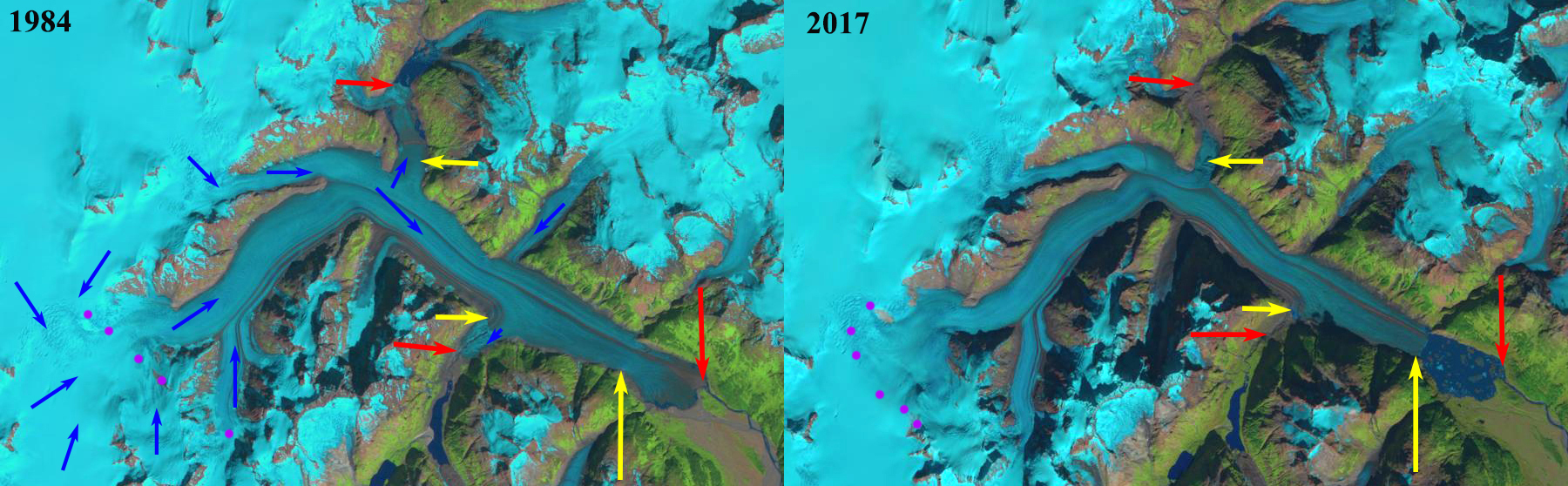
Tulsequah Glacier in 1984 and 2017 Landsat images. The 1984 terminus location is noted with red arrows for the main and northern distributary tongue, southern distributary red arrow indicates lake margin. The yellow arrows indicate the 2017 glacier terminus locations. The retreat of 2900 m since 1984 led to a lake of the same size forming. Purple dots indicate the snowline.
Tulsequah Glacier, British Columbia is a remote glacier draining from the Alaska-Canada boundary mountains of the Juneau Icefield. It is best known for its Jökulhlaups from lakes dammed by Tulsequah Glacier in northwestern British Columbia, Canada (Neal, 2007). The floods pose a hazard to the Tulsequah Chief mining further downstream. The continued retreat of the main glacier at a faster rate than its subsidiary glaciers raises the potential for an additional glacier dammed lakes to form. The main terminus has disintegrated in a proglacial lake. Retreat from 1890-1984 had been much slower than the last thirty years. This glacier feeds the Taku River which has seen a significant decline in salmon in the last decade (Juneau Empire, 2017). Here we utilize Landsat images from 1984-2017 to illustrate changes in this glacier, updating the retreat noted by Pelto (2017).
As part of the onoging Juneau Icefield Research Program we completed extensive snow pack measurements in the upper reach of the glacier in 1981-1984 and found that snow depths in August near the end of the melt season between 1700-2000 meters averaged 4-6 meters. This high snowfall accumulation is also indicated by modelling in a recent publication, in a project led by Aurora Roth, @ UAlaska-Fairbanks, that I participated in.
In 1984 the glacier has a low sloped terminus tongue with a narrow fringe of water indicating the initial formation of a lake. The northern distributary terminus extends 3.5 km north from the main glacier. The southern distributary tongue that blocked the main glacier dammed lake in the past, extending south from the main glacier, now terminates near the main glacier, with the red arrow indicating the southern end of the lake basin. The snowline is at 1300 m. By 2001 the fringing lake extends along the margin for 3 km and is 200-400 m wide. The northern distributary terminus extends just 500 m from the main glacier. The southern distributary glacier dammed lake still forms as indicated by icebergs. The snowline is at 1450 m. The snowline is at ~1300 m. In a 2007 Google Earth image the collapsing terminus is still connected to the main glacier. By 2015 the terminus tongue has collapsed with the new proglacial lake still filled by numerous icebergs. The southern distributary tongue no longer has icebergs indicating lake formation at this location. By 2017 the terminus has retreated 2900 m since 1984, with a new 3 km long proglacial occupying the former glacier terminus. Also note the first tributary entering the glacier from the north in 1984 no longer reaches the glacier in 2017. The northern distributary tongue has icebergs indicating lake formation still occurs. The snowline in 2017 is at 1450 m. The issue driving the retreat is that the equilibrium line where melting equals accumulation and bare glacier ice is exposed has risen and is now typically at 1400 meters. Berthier et al (2018), in a paper I had the pleasure of reviewing, indicate thinning from 2000-2016 greater than 2.5 m per year below 1000 m, with some thinning extending right to the crest of the glacier in all but the northwest corner. This will drive continued retreat. This retreat is not as spectacular as at Porcupine Glacier to the south. This is not unlike the situation at the Gilkey Glacier just delayed.
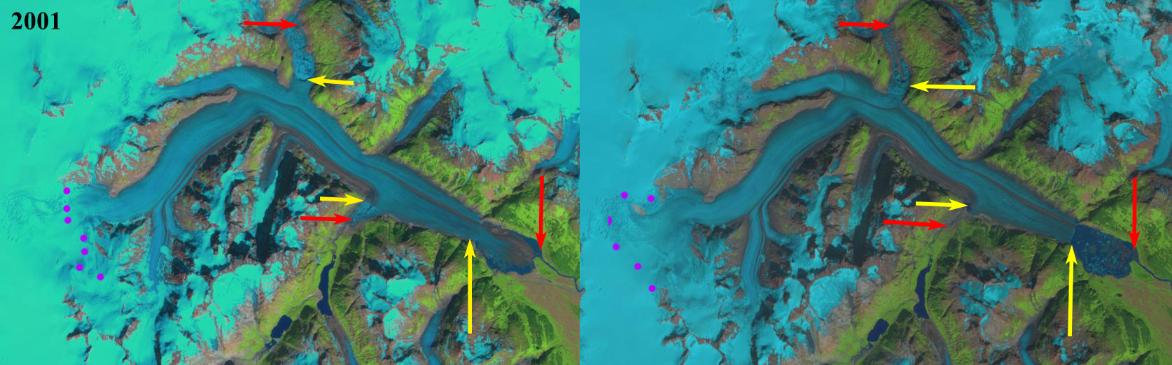
Tulsequah Glacier in 2001 and 2015 Landsat images. The 1984 terminus location is noted with red arrows for the main and northern distributary tongue, southern distributary red arrow indicates lake margin. The yellow arrows indicate the 2017 glacier terminus locations. Purple dots indicate the snowline.

2007 Google Earth image indicating the fialing connection of the main glacier to the terminus tongue.
 Dean of Academic Affairs at Nichols College and Professor of Environmental Science at Nichols College in Massachusetts since 1989. Glaciologist directing the North Cascade Glacier Climate Project since 1984. This project monitors the mass balance and behavior of more glaciers than any other in North America.