
30 August 2017
Before and after satellite images of the Pizzo Cengalo rock avalanche
Posted by Dave Petley
Before and after satellite images of the Pizzo Cengalo rock avalanche
The clean up in the aftermath of the Pizzo Cengalo rock avalanche in Switzerland continues amidst reports of continued small-scale but significant ongoing landslide activity. Swissinfo reports that the search for the eight missing hikers has now been abandoned, whilst the reconstruction phase may take up to three years. The report also includes this slightly intriguing sections:
The landslide is one of the largest to hit Switzerland in the last century. Piz Cengalo had been under observation since 2011, when another – albeit largely unnoticed – landslide caused 1.5 million cubic metres of the mountainside to collapse.
The implication is that the section of slope that had been causing concern remains intact, but I may be misinterpreting what is meant here. I wonder if any readers have further information?
Meanwhile, the site of the landslide continues to be imaged by satellites, and cloud free images from before and after the event (in addition to the image during the collapse, about which I previously posted) are now available. This is a Planet Labs image from 4th August 2017, showing the site of the landslide before the collapse:-
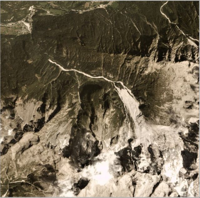
Planet Labs image of the site of the Pizzo Cengalo rock avalanche, dated 4th August 2017
.
And this image, dated 29th August 2017, shows the aftermath:-
.
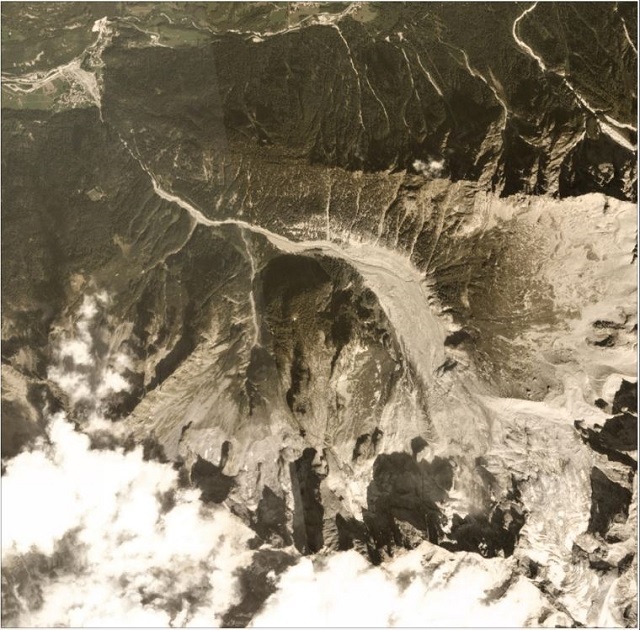
Planet Labs image of the aftermath of the Pizzo Cengalo rock avalanche, dated 29th August 2017
.
These two images nicely capture both the source of the landslide (i.e. the change is the scar area) and the new landslide deposit. Note that the volume of material that reached the village is quite small compared to the totral landslide volume, but there is now a huge amount of debris stored in the slopes above the settlement. This is the state of the village of Bondo itself:-
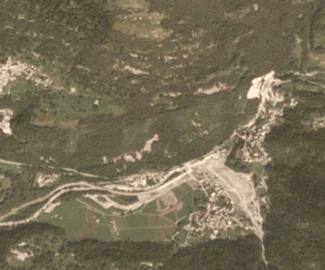
Planet Labs image dated 29th August 2017 showing the aftermath of the Pizzo Cengalo rock avalanche.
.
It is worth comparing that with this Google Earth image showing the same location in 2010, before the current landslide sequence began:-
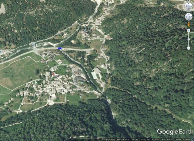
Google Earth image from 2010 showing the location of the village of Bondo before the current landslide sequence.
.
Acknowledgement
Planet Team (2017). Planet Application Program Interface: In Space for Life on Earth. San Francisco, CA. https://api.planet.com
 Dave Petley is the Vice-Chancellor of the University of Hull in the United Kingdom. His blog provides commentary and analysis of landslide events occurring worldwide, including the landslides themselves, latest research, and conferences and meetings.
From what I’ve gathered, laser and radar scans in the years before this latest slide indicated a total unstable volume of ~5 million m3 (e.g. see here: http://www.labregaglia.ch/?p=86214), and the Aug 23 rock avalanche released roughly ~4 million m3 so ~1 million is expected to remain unstable in the source area.
The 27 Dec 2011 event interestingly went unnoticed for a few days (upper part of the valley was not inhabited that time of year, perhaps poor weather?). However, seismic signals from that event were immediately detected and being discussed by the SED. As far as I know it’s the same general source for the 2011, 2016 and 2017 failures. Not personally involved in the work, just piecing together information from media sources.
Here you can find some more intersting pictures from the rock avalanche and the valley below.
https://blog.tagesanzeiger.ch/zoom/index.php/93184/im-verwuesteten-tal/
https://blog.tagesanzeiger.ch/zoom/index.php/92817/der-bergsturz-von-bondo/