
30 August 2015
Sitka landslide in Alaska – the potential power of simple geomorphic mapping
Posted by Dave Petley
Sitka landslide in Alaska
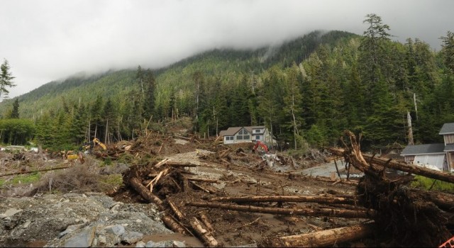
Heavy rainfall in Alaska on Tuesday 18th August triggered landslides in the town of Sitka in Alaska, the worst of which killed three men. The Alaska Dispatch News has the best image of the landslide that I’ve seen to date:
.
It is clear that this is a flow type slide that has originated on the steep forested flanks of Harbor Mountain. The landslide tore through a new housing development on the so-called benchland area of Sitka, which it had been hoped would provide a solution to the housing problems faced by the town. There is a good account of the disaster declaration for the landslides in Sitka on KTVA Alaska, and of the likely implications of the landslides in an article on the Alaska Dispatch News website. Part of the development of the housing project included the construction of a water tower. The geotechnical report for this project is also available online and makes interesting reading. This is a part of the documentation that was provided for the auction of lots in the housing subdivision.
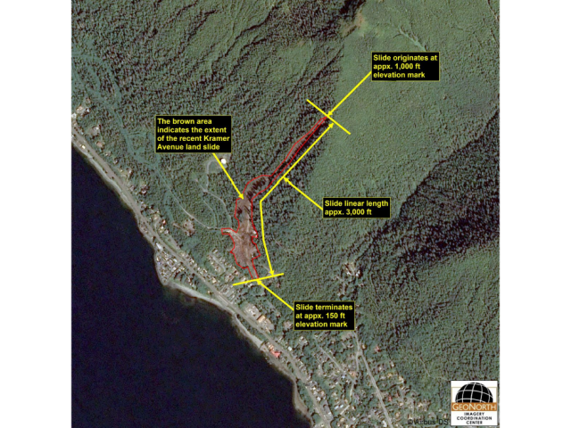
The aftermath of the landslide itself has captured in a high resolution SPOT7 satellite image, and is available in annotated form on the GeoNorth website:
SPOT 7 via Geonorth
.
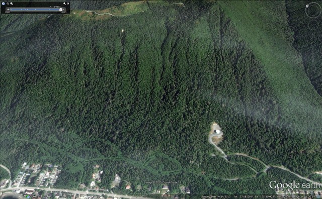
A few things to note here. First, it was lucky that the landslide didn’t travel a little further. Second, and more importantly, the landslide started very close to a ridge in a forested section of the slope, possibly as a reasonably small landslide that appears to have entrained debris to become a high energy flow. Thirdly, the water tank is clearly visible on the image. And fourthly, the slope appears to have very interesting geomorphology, with multiple gullies. So let’s take a look at the Google Earth image, which is of a high quality for this site:
Google Earth
. .
It is clear that the slope is characterised by multiple incised channels, many of which extend from the ridgeline. Note that at least some have a broader crown area and then a narrow track. These look to me to be classic debris flow channels, at least some of which come extend down to the roads associated with potential housing developments. The Sitka landslide itself is very close to one of these channels, and may even have occupied one. And interestingly, the geotechnical report identifies “ancient landslide” deposits:
Ancient Landslide
This unit is composed of varying mixtures of volcanic ash, glacial drift, and organic materials. These deposits are typically reddish brown, moist to wet, compact to dense, and vary in thickness from 1.5 ft to 18.5 ft. The average moisture content was 27%. Landslide deposits commonly exhibit characteristics of disturbed volcanic ash and are generally unsuitable as a bearing surface or as fill material.
To me as a geomorphologist, the presence of those gullies on the slope, and their shape, is enough to ask serious questions about the site. Combined with ancient landslide deposits in the vicinity of the houses themselves, my concern would increase. And note that the ancient landslide deposits lie above glacial drift (i.e. the remains from a recent ice age), and ash from one or more volcanic eruptions. This suggests to me that these landslide deposits might not be very ancient in geological terms.
I have no idea whether a simple geomorphic analysis was undertaken of the slope but I would be interested to find out. Not unusually perhaps, it seems it wasn’t part of the brief for the geotechnical report, which seems to me to be a perfectly competent document within the scope of such a study. O
I would also add that , of course, knowing that this is a slope that is prone to landslides does not necessarily preclude development of the benchland area of Sitka, but appropriate mitigation would be essential.
Simple engineering geomorphic mapping is a very powerful tool. It is used far too infrequently in my view. I have no idea how this slope was assessed. Was geomorphic mapping used here, and if so what did it show? If not, how have the hazards associated with this slope been assessed?
 Dave Petley is the Vice-Chancellor of the University of Hull in the United Kingdom. His blog provides commentary and analysis of landslide events occurring worldwide, including the landslides themselves, latest research, and conferences and meetings.